Bahraich district

Last updated

Bahraich district
Qadam e Rasul Dargah Bahraich.jpg
Leaving the cold desolation.jpg
Top: Qadam Sharif - e - Rasul E Pak عليه السلام Dargah Sharif, Bahraich
Bottom: Birds in Katarniaghat Wildlife Sanctuary
India Uttar Pradesh districts 2012 Bahraich.svg
Location of Bahraich district in Uttar Pradesh
CountryFlag of India.svg  India
State Uttar Pradesh
Division Devipatan
Headquarters Bahraich
Tehsils 6
Government
   Lok Sabha constituencies Bahraich, Kaiserganj
Area
  Total4,696.8 km2 (1,813.4 sq mi)
Population
 (2011)
  Total3,487,731
  Density666/km2 (1,720/sq mi)
   Urban
186,223
Demographics
   Literacy 49.32 per cent
Time zone UTC+05:30 (IST)
Major highways NH28C, SH96
Average annual precipitation1710 mm
Website bahraich.nic.in

Bahraich district is one of the districts of Uttar Pradesh state of India, and Bahraich town is the district headquarters. Bahraich District is a part of Devipatan Division.

Contents

History

Bahraich is located in the state of Uttar Pradesh, India. It has a rich history that spans several centuries. Here's an overview of the history of Bahraich:

Ancient and Medieval Periods: The region around Bahraich has a history dating back to ancient times. It was part of the kingdom of Kosala, which was mentioned in ancient Indian texts such as the Ramayana and the Mahabharata. The area saw the rule of various dynasties, including the Mauryas, Guptas, and the Palas.

During the medieval period, Bahraich came under the control of the Delhi Sultanate in the 13th century. It later passed into the hands of the Mughal Empire. Bahraich served as an important administrative center during the Mughal era.

British Rule and Independence: In the 18th century, Bahraich came under the control of the Nawabs of Awadh. With the decline of the Mughal Empire, the British East India Company gradually established its influence in the region. The city became a part of British India in the 19th century and was administered as a part of the United Provinces of Agra and Oudh.

During the Indian independence movement, Bahraich played an active role. It witnessed several protests and movements against British colonial rule. After India gained independence in 1947, Bahraich became a part of the newly formed state of Uttar Pradesh.

Modern Development: In the post-independence period, Bahraich has undergone significant development and growth. It has become an important center for trade, commerce, and agriculture. The city has witnessed the establishment of educational institutions, hospitals, and other infrastructure.

Bahraich is known for its diverse cultural heritage, with a blend of Hindu, Muslim, and other religious traditions. The city is also home to several historical landmarks and monuments, such as the Dargah of Sayyed Salar Masud, a renowned Sufi saint.

Today, Bahraich continues to develop as a thriving urban center, contributing to the socio-economic growth of Uttar Pradesh and India as a whole.

Bahraich district is a part of Devipatan division consist of districts Bahraich, Gonda, Shravasti, Balrampur. You can find more than 50 famous Hindu Temple in bahraich district.

Geography

Bahraich District is situated in the northern part of the Indian state of Uttar Pradesh. It lies between the Ghaghra and Saryu rivers and is bordered by Nepal to the north. Here's an overview of the geography of Bahraich District:

Location: Bahraich District is located at approximate coordinates of 27.58°N latitude and 81.59°E longitude.

Topography: The district's terrain is characterized by a mix of plain and hilly areas. The northern part of the district, bordering Nepal, is mountainous and forms a part of the foothills of the Himalayas. The southern part is predominantly plain, formed by the Gangetic alluvial plains.

Rivers: The district has two major rivers, the Ghaghra and the Saryu, which flow through its territory. The Ghaghra River forms the eastern boundary of the district, while the Saryu River runs through the western part.

Natural Features: Bahraich District has several natural features, including forests and wetlands. The Katarniaghat Wildlife Sanctuary, located in the district, is an important protected area known for its rich biodiversity. It is home to various species of flora and fauna, including tigers, elephants, and reptiles.

Climate: The climate of Bahraich is characterized as subtropical, with hot summers and cool winters. Summers, from April to June, are hot and dry, with temperatures often exceeding 40°C (104°F). Monsoon season, from July to September, brings moderate to heavy rainfall. Winters, from November to February, are relatively cool, with temperatures ranging from 8°C to 20°C (46°F to 68°F).

Vegetation: The district's vegetation mainly consists of agricultural fields, forests, and grasslands. The plains are primarily used for agriculture, with crops such as wheat, rice, sugarcane, and pulses being grown. The hilly regions are covered with dense forests, including sal, teak, and bamboo.

Overall, Bahraich District boasts a diverse geographical landscape, ranging from plains to hills, and is characterized by its rivers, forests, and agricultural lands.

Economy

Bahraich District has an economy primarily driven by agriculture, trade, and small-scale industries. Here are some key details about the economic aspects of Bahraich District:

  1. Agriculture: Agriculture is the primary occupation in Bahraich, with a significant portion of the population engaged in farming. The fertile Gangetic plains in the southern part of the district support the cultivation of various crops. The major crops grown include rice, wheat, sugarcane, pulses, oilseeds, and vegetables. The district also has a considerable number of farmers involved in animal husbandry, particularly dairy farming.
  2. Industries: Bahraich District has a growing small-scale industrial sector. The industries are mainly concentrated in areas such as wood and timber processing, brick kilns, handicrafts, and cottage industries. The district is known for its wood carving industry, which produces intricate wooden furniture and decorative items.
  3. Trade and Commerce: Bahraich serves as a commercial center for the surrounding rural areas. The district has local markets, shops, and wholesale markets where agricultural produce and other goods are traded. The city of Bahraich has developed as a commercial hub with various businesses, including retail stores, hotels, and transportation services.
  4. Handicrafts: Handicrafts play a significant role in the economy of Bahraich. The district is known for its skilled artisans who produce a range of handicraft products, including wood carvings, handloom textiles, pottery, and brassware. These handicrafts have both local and regional demand, and they contribute to the district's economy through sales and exports.
  5. Government Employment: The government sector is also an important source of employment in Bahraich. Various government offices, educational institutions, healthcare facilities, and public sector enterprises provide employment opportunities to the local population.
  6. Tourism: Bahraich has a few tourist attractions, such as the Dargah of Sayyed Salar Masud, which attracts devotees and tourists. The district's natural beauty, including the Katarniaghat Wildlife Sanctuary, also has the potential to promote tourism.

It's important to note that Bahraich, like many other regions in India, faces economic challenges such as poverty, lack of infrastructure, and limited access to resources. However, efforts are being made to promote economic growth and development in the district through various government initiatives and programs.

Demographics

Historical population
YearPop.±% p.a.
1901764,477    
1911761,611−0.04%
1921774,317+0.17%
1931825,923+0.65%
1941901,675+0.88%
1951978,553+0.82%
19611,098,695+1.16%
19711,282,218+1.56%
19811,672,410+2.69%
19912,090,852+2.26%
20012,701,478+2.60%
20113,487,731+2.59%
source: [1]
Religions in Bahraich district (2011) [2]
ReligionPercent
Hinduism
65.71%
Islam
33.53%
Other or not stated
0.76%
Distribution of religions

According to the 2011 census Bahraich district has a population of 3,487,731, [3] This gives it a ranking of 89th in India (out of a total of 640). [3] The district has a population density of 706 inhabitants per square kilometre (1,830/sq mi). [3] Its population growth rate over the decade 2001–2011 was 46.08%. [3] Bahraich has a sex ratio of 891 females for every 1000 males, and a literacy rate of 49.32%. 8.14% of the population lives in urban areas. Scheduled Castes and Scheduled Tribes made up 14.60% and 0.32% of the population respectively. [3]

Bahraich is a category "A" district i.e. having socio-economic and basic amenities parameters below the national average. [4]

Hindus are the majority population, but Muslims are a large minority. In urban areas Muslims are the majority. There are small populations of Sikhs, Christians and Buddhists in the district. [2]

Languages of Bahraich district (2011) [5]

   Hindi (89.36%)
   Urdu (7.02%)
   Awadhi (1.82%)
   Bhojpuri (1.49%)
  Others (0.31%)

At the time of the 2011 Census of India, 89.36% of the population in the district spoke Hindi, 7.02% Urdu, 1.82% Awadhi and 1.49% Bhojpuri as their first language. [5]

Tehsil

Bahraich district comprises 6 tehsils or sub-divisions, each headed by a Sub-Divisional Magistrate (SDM): [6]

  1. Bahraich
  2. Kaisarganj
  3. Nanpara
  4. Payagpur
  5. Motipur (Mihinpurwa)
  6. Mahsi

Related Research Articles

Mau, also now known as Maunath Bhanjan, is an industrial town and the headquarter of the Mau district. It is located in the eastern part of Uttar Pradesh, India. The town is known for its saree industry which is a traditional business and centuries old art of the people of this city; says, Pallavi Mishra.

<span class="mw-page-title-main">Bahraich</span> City in Uttar Pradesh, India

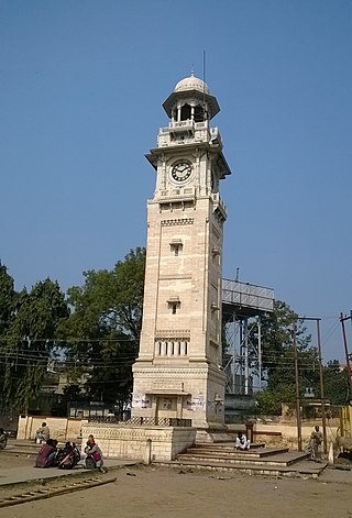
Bahraich is a city and a municipal board in Bahraich district in the state of Uttar Pradesh, India. Located on the Saryu River, a tributary of the Ghaghara river, Bahraich is 125 kilometres north-east of Lucknow, the state capital. The districts of Barabanki, Gonda, Balrampur, Lakhimpur Kheri, Shravasti and Sitapur share boundaries with Bahraich. A factor which makes this town important is the international border shared with Nepal.

<span class="mw-page-title-main">Ghaghara</span> Longest River of Nepal

The Karnali River, called Ghaghara River in India, Mapcha Tsangpo in Tibet, and the lower Ghaghara in Awadh called Sarayu River, is a perennial trans-boundary river that originates in the northern slopes of the Himalayas in the Tibetan Plateau, cuts through the Himalayas in Nepal and joins the Sharda River at Brahmaghat in India. Together they form the Ghaghara River, a major left-bank tributary of the Ganges. With a length of 507 km (315 mi), it is the longest river in Nepal. The total length of the Ghaghara up to its confluence with the Ganges at Revelganj in Bihar is 1,080 km (670 mi). It is the largest tributary of the Ganges by volume and the second largest by length after Yamuna.

<span class="mw-page-title-main">Bulandshahr district</span> District of Uttar Pradesh in India

Bulandshahr district is a district in the Meerut region in the north Indian state of Uttar Pradesh (UP), situated between the Ganga and Yamuna rivers. It is a part of the National Capital Region of India, and Bulandshahr is the district headquarters.

<span class="mw-page-title-main">Bareilly district</span> District of Uttar Pradesh in India

The Bareilly district belongs to the state Uttar Pradesh in northern India. Its capital is Bareilly city and it is divided in six administrative division or tehsils: Aonla, Baheri, Bareilly city, Faridpur, Mirganj, and Nawabganj. The Bareilly district is a part of the Bareilly Division and occupies an area of 4120 km2 with a population of 4,448,359 people according to the census of 2011.

<span class="mw-page-title-main">Deoria district</span> District of Uttar Pradesh in India

Deoria district, one of the districts of eastern Uttar Pradesh, India has its headquarters located at Deoria and is a part of Gorakhpur division. It came into existence on 16 March 1946 from Gorakhpur district.

<span class="mw-page-title-main">Firozabad district</span> District of Uttar Pradesh in India

Firozabad district is one of the western districts of the Indian state of Uttar Pradesh, which has Firozabad city as its district headquarters. The district is a part of the Agra division.

<span class="mw-page-title-main">Mau district</span> District in Uttar Pradesh, India

Mau district is one of the districts of Uttar Pradesh state of India, and Mau town is the district headquarters which is also one of the few remaining areas of handloom saree production in eastern Uttar Pradesh, specializing in Sadiya silk sarees. Mau was carved out as a separate district from Azamgarh on 19 November 1988. It is situated in the south-eastern part of the state with headquarters in Maunath Bhanjan. The district is surrounded by Ghazipur district on the south, Ballia district in the east, Azamgarh district in the west, and by Gorakhpur and Deoria districts on the north; says, Pallavi mishra.

<span class="mw-page-title-main">Shravasti district</span> District of Uttar Pradesh in India

Shravasti district is one of the districts of the Uttar Pradesh state of India, with Bhinga town as its district headquarters. Shravasti district is a part of Devipatan Division. According to Government of India, it is among the 121 minority concentrated districts in India. It is the fourth most backward district in India, according to the 2018 Niti Aayog ranking. This district is the most poverty stricken district in the country.

<span class="mw-page-title-main">Ambedkar Nagar district</span> District in Uttar Pradesh, India

Ambedkar Nagar is one of the 75 districts in the northern Indian state of Uttar Pradesh. This district is a part of Ayodhya division in the Awadh region of the state. This district was established on 29 September 1995 by carving out parts of the erstwhile Faizabad district. It was created by the then Chief Minister Mayawati and named in memory of Dr. Bhimrao Ambedkar, who worked for the advancement of the depressed classes. The total area of Ambedkar Nagar district is 2350 Sq. Km.

<span class="mw-page-title-main">Saharanpur district</span> District of Uttar Pradesh in India

Saharanpur district is the northernmost of the districts of Uttar Pradesh state, India. Bordering the states of Haryana, Himachal Pradesh and Uttarakhand, and close to the foothills of Shivalik range, it lies in the northern part of the Doab region.

<span class="mw-page-title-main">Sitapur district</span> District of Uttar Pradesh in India

Sitapur district is one of the districts which is situated in Uttar Pradesh state of India, with Sitapur town as the district headquarters. Sitapur district is a part of Lucknow division.

<span class="mw-page-title-main">Bhadohi district</span> District in Uttar Pradesh, India

Bhadohi district is a district of Uttar Pradesh state in northern India. The city of Bhadohi is the district headquarters. Bhadohi is one of largest centres of Carpet Industries in India and is worldwide known as 'Carpet City of India'. Carpets of Bhadohi have 'Geographical Indication' tag attached to it. Bhadohi has huge geographical significance and position attached to it due to its location between two culturally important and rich heritage cities of Prayagraj and Varanasi.

<span class="mw-page-title-main">Gonda district</span> District of Uttar Pradesh in India

Gonda district is one of the districts of Uttar Pradesh, India. The city of Gonda is the district headquarters, and also the administrative centre for the Devipatan Division. The total area of Gonda district is 4,003 km2 (1,546 sq mi).

<span class="mw-page-title-main">Jhansi district</span> District of Uttar Pradesh in India

Jhansi district is one of the districts of Uttar Pradesh state in northern India. The city of Jhansi is the district headquarters. The district is bordered on the north by Jalaun District, to the east by Hamirpur and Mahoba districts, to the south by Tikamgarh District of Madhya Pradesh state, to the southwest by Lalitpur District, which is joined to Jhansi District by a narrow corridor, and on the east by the Datia and Bhind districts of Madhya Pradesh. Population 19,98,603. Lalitpur District, which extends into the hill country to the south, was added to Jhansi District in 1891, and made a separate district again in 1974.

<span class="mw-page-title-main">Hardoi district</span> District of Uttar Pradesh in India

Hardoi district is a district situated in the center of Uttar Pradesh, India. The district headquarters is in the city of Hardoi. Hardoi is the third largest district of Uttar Pradesh. It falls under Lucknow division in the historical region of Awadh State.

<span class="mw-page-title-main">Moradabad district</span> District of Uttar Pradesh in India

Moradabad district is one of the districts of Uttar Pradesh, India. The city of Moradabad is the district headquarters. Moradabad district is part of Moradabad division. It is used to be the second most populous district of Uttar Pradesh, after Prayagraj till a new district Sambhal was carved out of it in 2011.

<span class="mw-page-title-main">Meerut district</span> District of Uttar Pradesh in India

Meerut district, is one of the districts of Uttar Pradesh state of India, with the city of Meerut as the district headquarters. Meerut district is also a part of the Meerut division. The administrative head of district of Meerut is a District Magistrate while the administrative head of Meerut Division is Divisional Commissioner, an IAS officer.

<span class="mw-page-title-main">Amroha district</span> District in Uttar Pradesh, India

Amroha is one of the 75 districts of Uttar Pradesh state in northern India. Amroha town is the district headquarters. According to the Government of India, the district is one of the Minority Concentrated Districts on the basis of the 2001 census data on population, socio-economic indicators and basic amenities indicators.

<span class="mw-page-title-main">Balrampur district, Uttar Pradesh</span> District of Uttar Pradesh in India

Balrampur district is one of the district of the Indian state of Uttar Pradesh and is a part of Devipatan division as well as the historic Awadh regions. It has been cut from the adjacent district Gonda in 1997. Located on the banks of the West Rapti River. Balrampur is known for the temple of Pateshwari Devi, a Shakti Pitha, and for the ruins of the nearby ancient city of Sravasti, now a pilgrimage site for Buddhists and Jains. The nearest airport is Shravasti airport 23.3 kilometres (14.5 mi) from the town but it is not an international and regular airport; the nearest international and regular airport is Chaudhary Charan Singh International Airport in Lucknow, 235 kilometres (146 mi) away. Lucknow is the capital city of Uttar Pradesh and is 220 kilometres (140 mi) from Balrampur district headquarters.

References

  1. Decadal Variation In Population Since 1901
  2. 1 2 "Table C-01 Population by Religion: Uttar Pradesh". censusindia.gov.in. Registrar General and Census Commissioner of India. 2011.
  3. 1 2 3 4 5 "District Census Handbook: Bahraich" (PDF). censusindia.gov.in. Registrar General and Census Commissioner of India. 2011.
  4. MINUTES OF THE 34th MEETING OF EMPOWERED COMMITTEE TO CONSIDER AND APPROVE REVISED PLAN FOR BALANCE FUND FOR THE DISTRICTS OF GHAZIABAD, BAREILLY, BARABANKI, SIDDHARTH NAGAR, SHAHJANPUR, MORADABAD, MUZAFFAR NAGAR, BAHRAICH AND LUCKNOW (UTTAR PRADESH) UNDER MULTI-SECTORAL DEVELOPMENT PROGRAMME IN MINORITY CONCENTRATION DISTRICTS HELD ON 22nd JULY, 2010 Archived 30 September 2011 at the Wayback Machine . No. 3/64/2010-PP-I, GOVERNMENT OF INDIA, MINISTRY OF MINORITY AFFAIRS
  5. 1 2 "Table C-16 Population by Mother Tongue: Uttar Pradesh". www.censusindia.gov.in. Registrar General and Census Commissioner of India.
  6. "Blocks | Administrative Setup | District Bahraich Official Site". District Bahraich. Retrieved 29 December 2021.