Varanasi division

Last updated

Varanasi division Varanasi division.svg
Varanasi division

Varanasi division is one of the 18 administrative geographical units (i.e. division) of the northern Indian state of Uttar Pradesh. Varanasi city is the administrative headquarters of the division. The division consists of 4 districts, i.e. Varanasi, Chandauli, Ghazipur, and Jaunpur and is loosely equivalent to the Benares State.

Contents

Districts

History

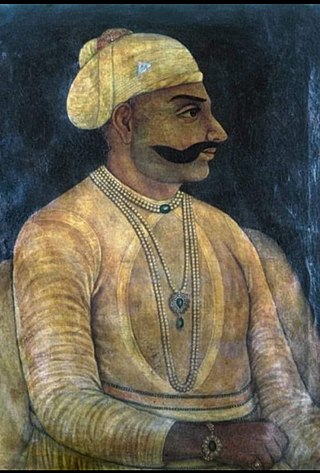
In the 18th century the Mughal Empire was dissolving, and the eastern portion of present-day Uttar Pradesh State came under the control of Saadat Ali Khan I, the first Nawab of Awadh. In 1722, Saadat Ali Khan sublet his southern territories, comprising the present-day districts of Bhadohi, Chandauli, Jaunpur, Ghazipur, Mirzapur, Sonbhadra, and Varanasi, to zamindar Mir Rustam Ali. Mir Rustam Ali was deposed in 1738, and Mansa Ram became zamindar. On Mansa Ram's death in 1739, his son Balwant Singh succeeded him, and established himself raja of Benares State. [1] Balwant Singh and added present-day Ghazipur and Ballia districts to his territories. Balwant Singh died in 1770, and the British intervened to get the Nawab to recognize his son and heir, Chait Singh, as raja. The Nawab of Awadh ceded the territory to the British in 1775, and the British confirmed Chait Singh as ruler.

The British deposed Chait Singh in 1781, and under his heir Mahip Narayan Singh, took administrative control over most of the territory, organizing it into Benares Division, comprising four districts: Benares, Ghazipur, Jaunpur, and Mirzapur. The rajas, later maharajas, of Benares retained certain administrative rights and revenues within the division, and directly governed a portion of the division, known as the Benares Estate. The rajas' principal residence was at Ramnagar, across the Ganges River from Benares. [2] Ballia district was separated from Ghazipur in 1879. [3]

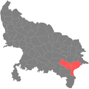
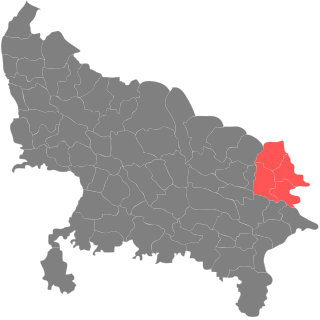
The Division had an area of 10,431 square miles, and was part of the United Provinces of British India. The administrative headquarters was at Benares.

The Division's population was 4,395,252 in 1872, 5,178,005 in 1881, 5,368,480 in 1891, and 5,069,020 in 1901. The decrease from 1891 to 1901 was attributed to an epidemic of fever following disastrous floods in 1894, and to famine and emigration. The 1901 census recorded the division's population as 91% Hindu, not quite 9% Muslim, with small populations of Christians and Sikhs. [4]

In 1911, the Benares Estate, which included two areas governed directly by the Maharajas, was separated from the division to form the Princely State of Benares.

In 1947, after India became independent, United Provinces of Agra and Oudh were renamed Uttar Pradesh. In 1948, the Maharaja of Benares (i.e. King of Varanasi) acceded to the Government of India, and Benares State was reintegrated into the Benares division, with the western portion becoming Bhadohi tehsil and the eastern portion becoming Chania tehsil of Varanasi district.

In 1989, the southeastern portion of Mirzapur district was separated into Sonbhadra district. In 1994, Bhadohi (officially known as Sant Ravidas Nagar) was separated from Varanasi district. In 1997, Chandauli district was separated from Varanasi district. [5]

After 2000, Varanasi division was reduced in size, with the districts of Bhadohi, Mirzapur, and Sonbhadra separated into the Mirzapur division, and Ballia district was made a part of Azamgarh division.

See also

Districts of Uttar Pradesh

Related Research Articles

<span class="mw-page-title-main">United Provinces of Agra and Oudh</span> Province in British India

The United Provinces of Agra and Oudh was a province of India under the British Raj, which existed from 22 March 1902 to 1937; the official name was shortened by the Government of India Act 1935 to United Provinces (UP), by which the province had been commonly known, and by which name it was also a province of independent India until 1950.

The Karamnasa or Karmanasa River is a tributary of the Ganges. It originates in Kaimur district of Bihar and flows through the Indian states of Uttar Pradesh and Bihar. Along the boundary between Uttar Pradesh and Bihar it has the districts of Sonbhadra, Chandauli, Varanasi and Ghazipur on its left ; and the districts of Kaimur and Buxar on its right.

<span class="mw-page-title-main">Jaunpur, Uttar Pradesh</span> City in Uttar Pradesh, India

Jaunpur is a city and a municipal board in Jaunpur district in the Indian state of Uttar Pradesh. It is located 228 km southeast of state capital Lucknow. Demographically, Jaunpur resembles the rest of the Purvanchal area in which it is located.

<span class="mw-page-title-main">Sonbhadra district</span> District in Uttar Pradesh, India

Sonbhadra or Sonanchal is the second largest district by area of Uttar Pradesh after Lakhimpur Kheri. The district headquarters is in the town of Robertsganj. Sonbhadra is also known as the "Energy Capital of India" because there are multiple power plants.

<span class="mw-page-title-main">Ghazipur</span> City in Uttar Pradesh, India

Ghazipur is a city in the state of Uttar Pradesh, India. Ghazipur city is the administrative headquarters of the Ghazipur district, one of the four districts that form the Varanasi division of Uttar Pradesh. The city of Ghazipur also constitutes one of the seven distinct tehsils, or subdivisions, of the Ghazipur district.

<span class="mw-page-title-main">Mirzapur division</span> Administrative division of Uttar Pradesh, India

Mirzapur division, also sometimes known as Vindhyachal division, is one of the 18 administrative geographical units of the northern Indian state of Uttar Pradesh. Mirzapur city is the administrative headquarters. Currently, the division consists of 3 districts:-

<span class="mw-page-title-main">Varanasi district</span> District in Uttar Pradesh, India

Varanasi district is a district in the Indian state of Uttar Pradesh, with the holy city of Varanasi as the district headquarters. It is also the headquarters of the Varanasi division which contains 4 districts.

<span class="mw-page-title-main">Gorakhpur division</span> Administrative division of Uttar Pradesh, India

Gorakhpur division is one of the 18 administrative geographical units of the northern Indian state of Uttar Pradesh. Gorakhpur city is the administrative headquarters of the division. The division consists of 4 districts.

<span class="mw-page-title-main">Bhadohi district</span> District in Uttar Pradesh, India

Bhadohi district is a district of Uttar Pradesh state in northern India. It is also referred to as Sant Ravidas Nagar. It is the smallest district by area in the state of Uttar Pradesh which was created on June 30, 1994 by dividing western part of the district Varanasi. It is surrounded by Varanasi district on east, Allahabad on west, Jaunpur north and Mirzapur district in south. The state capital Lucknow is distanced at 234 KM from Bhadohi. Its district headquarters is situated in the city of Gyanpur. The district is popularly known for carpet weaving as it is one of largest centres of Carpet Industries in India and therefore it also known as the 'Carpet City of India'. Carpets of Bhadohi have 'Geographical Indication' tag attached to it. Bhadohi has huge geographical significance and position attached to it due to its location between two culturally important and rich heritage cities of Prayagraj and Varanasi.

<span class="mw-page-title-main">Banarasi sari</span> Indian Sari made in Varanasi

A Banarasi sari is a sari made in Varanasi, an ancient city which is also called Benares (Banaras). The saris are among the finest saris in India and are known for their gold and silver brocade or zari, fine silk and opulent embroidery. The saris are made of finely woven silk and are decorated with intricate designs, and, because of these engravings, are relatively heavy.

<span class="mw-page-title-main">Mirzapur district</span> District in Uttar Pradesh, India

Mirzapur district is one of the 75 districts in the Indian state of Uttar Pradesh. The district is bounded on the north by Bhadohi and Varanasi districts, on the east by Chandauli district, on the south by Sonbhadra district and on the northwest by Prayagraj. The district occupies an area of 4521 km2. Mirzapur city is the district headquarters. Mirzapur district is a part of Mirzapur division. This district is known for the Vindhyavasini temple in Vindhyachal and several tourist attractions like water falls like Rajdari & Devdari and dams. It consist of several Ghats where historical sculptures are still present. During the Ganges festival these Ghats are decorated with lights and diyas.

Chandauli is a town and a nagar panchayat in Chandauli district in the state of Uttar Pradesh, India. It is the administrative headquarters of Chandauli District.

<span class="mw-page-title-main">Ghazipur district</span> District in Uttar Pradesh, India

Ghazipur district is a district of Uttar Pradesh state in northern India. The city of Ghazipur is the district headquarters. The district is part of Varanasi Division. The region of Ghazipur is famous mainly for the production of its unique rose-scented Spray called Gulab Jal, and for the tomb of the Governor General of British India, Lord Cornwallis, who died here. His tomb is situated in Western part of City, and is conserved by Archaeological Survey of India.

<span class="mw-page-title-main">Benares State</span> Indian kingdom and later princely state (1740–1948)

Banaras State initially known as Banaras kingdom or Kashi Kingdom was a kingdom and later princely state under the Narayan Dynasty in what is today Uttar Pradesh, India. On 15 October 1948, Benares' last ruler signed the accession to the Indian Union.

<span class="mw-page-title-main">Vibhuti Narayan Singh</span> Indian scholar, Maharaja Bahadur of Benares from 1939–1948

Maharaja Vibhuti Narayan Singh was the king of Benares, a city considered holy, located in the Indian state of Uttar Pradesh. He was the last Bhumihar Brahmin king of the Kingdom of Kashi.

<span class="mw-page-title-main">Narayan dynasty</span> Bhumihar dynasty

The Narayan dynasty was the ruling family of Benares. After seceding from Awadh, Benares emerged as a kingdom of its own, ruled by Maharaja Balwant Singh in the 18th century. Since then, the family has ruled Benares. They belonged to the Bhumihar Brahmin community. In 1911, Benares became a full-fledged princely state of British India and the Narayan dynasty ruled it as British vassals until they acceded to independent India in 1947.

<span class="mw-page-title-main">Madhupur, Sonbhadra</span> Town in Uttar Pradesh, India

Madhupur is a census town in Sonbhadra district in the Indian state of Uttar Pradesh. It is located 17 km from Robertsganj which is the administrative headquarters of Sonbhadra District. The district Sonbhadra was created by carving off the southern part of the earlier Mirzapur district on 4 March 1989. Son, Karmnasha, Chandra Prabha, Rihand, Kanhar, Renu, Ghagar and Belan Rivers drain this area. in which Son River in main.

Pindra is one of three tehsils (sub-districts) in Varanasi district in the Indian state of Uttar Pradesh. Pindra is situated 24 kilometers from the city of Varanasi and has 424 villages.

<span class="mw-page-title-main">Maharaja Balwant Singh of Benares</span> Maharaja Bahadur of Benares from 1738–1770

Balwant Singh Sahib Bahadur, also known as Maharaja Balwant Singh (1711–1770), was the ruler of Benares State in northern India.

References

25°19′12″N83°00′36″E / 25.3200°N 83.0100°E / 25.3200; 83.0100