Ghazipur district

Last updated

Ghazipur
Ghazipur
Lord Cornwallis Tomb.jpg
India Uttar Pradesh districts 2012 Ghazipur.svg
Location of Ghazipur district in Uttar Pradesh
Coordinates(Ghazipur): 25°37′N83°34′E / 25.61°N 83.57°E / 25.61; 83.57
CountryFlag of India.svg  India
State Uttar Pradesh
Division Varanasi
Incorporated1 January 1879
Headquarters Ghazipur
Tehsils
Government
   District Magistrate Aryka Akhoury, IAS
   Lok Sabha constituencies Ghazipur
   Member of Parliament, Lok Sabha Vacant
Area
  Total3,377 km2 (1,304 sq mi)
Population
 (2011)
  Total3,620,268
  Estimate 
(2021)
4,210,000
  Density1,100/km2 (2,800/sq mi)
   Urban
434,697
Demographics
   Literacy 74.46%. [1]
  Sex ratio951
  Language HindiUrdu
Time zone UTC+05:30 (IST)
Vehicle registration UP-61
Major highways
  • NH-29
  • NH-19
  • NH-97
  • SH-36
  • SH-67
  • SH-69
  • SH-99
Average annual precipitation1109 mm
Website Official Website

Ghazipur district is a district of Uttar Pradesh state in northern India. The city of Ghazipur is the district headquarters. The district is part of Varanasi Division. The region of Ghazipur is famous mainly for the production of its unique rose-scented Spray called Gulab Jal, and for the tomb of the Governor General of British India, Lord Cornwallis, who died here. His tomb is situated in Western part of City, and is conserved by Archaeological Survey of India.

Contents

History

Early history

The district has derived its name from its headquarters town of Ghazipur. It was during the reign of Harsha, a Chinese pilgrim known with the name of Hiuen–T- Sang came to the district. And in his days the place was known as Chen- Chu interpreting in English as the Kingdom of the lord of 'Battles' which has been given various nomenclatures like Yudhpatipura, Yudharanpura, Garzapatipura and the last one probably who the modern Ghazipur as adopted by Lord Cunninghum. The Chinese pilgrim Hiuen-T-Sang had stated that a stupa was erected by Ashoka in the memory of Buddha who had been here in the district. Regarding the nomenclature of Ghazipur there has also been a version that it has its derivation from the word "Ghadi", who happened to be a Hindu king in the 9th century the original name of the place was Gadhipura. But, Gandhipura was located little far from the present city of Ghazipur. [2] [3]

According to one story Raja Mandhata was said to have been an heir (descendant) of Prithvi Raj of Delhi and was suffering from a skin disease and wanted to get rid of the affliction by bathing in the tank at Kathot. He did take bath under the direction of Brahmins and cured sometimes later. After overcoming his disease he settled in Ghazipur and built a fort. Subsequently, his nephew and his successors seized a Muslim girl whose mother got worried for her daughter and as a measure for the safety of her daughter, she appealed to the sultan of Delhi, with the result that a band of forty ghazis under the headship of Ghazi Saiyad Mausaud reached Kathot and captured the fort and slew Raja Mandhata and his nephew. Thus the Ghazis got charge of the area and where Masud is supposed traditionally to have founded a city in 1330 commemorating his newly acquired title of Malik-Us-Sadal Ghazi. He established a new city near to the old Gandhipura and the place got name Ghazipur. [2] [3] [4] [5]

The region covered by the present district of Ghazipur once formed part of the ancient kingdom of Kashi, a famous centre of Aryan civilization. The ancient history of Ghazipur can, therefore, be pieced out from that of Kashi. Archaeological finds of SaidpurAurihar and Bhitri also proved that it is related to an oldest time. The Chinese pilgrim Hiuen- T-Sang (630 to 644) visited and described this place. A legend states that the Jamadagani Rishi lived near to the present day Zamania town with his wife. According to the Mahabharat, Haihaya king Kartivirya came to residence of Jamadagni Rishi, after hospitality, he had taken Kamdhenu by force, but Parshuram son of Jamadagani Rishi overcome him and Kamdhenu was recovered. Kartivirya offered a sacrifice in atonement of his sin. [2] [3] [4] [5]

The early political history of this region is complex, Purans and Mahabharat, classical Sanskrit texts, the early Jain and Buddhist texts have given information in this regard. The Jains also testify to the greatness of the region under Kashi king Ashwasena as the father of Tirthankara Parshvanath. During the two or three centuries preceding the birth of Mahavira and the Buddha, the whole of northern India was divided into sixteen principal states known in early Buddhist and Jain literatures as the Solah Mahajanpada. The kingdom of Kashi was predominant in this period and covered the present district of Ghazipur. During the 8th and 7th centuries B.C. Kashi and Kosala fought against each other, which is stated in the Jatakas, early in the sixth century, Kashi kingdom completely collapsed in its struggle with Kosala. After the fall of the Kanvas (27 BC) Kashi seems to have been occupied by the Vatsas of Kaushambi. In the last of first century A.D. the Kushanas had established a state kingdom in the greater part of the northern India. Kushans rules came to end in the beginning of 3rd century in this region and a branch of Nagas, Bharashiva took the region in their hand. For nearly two centuries (from about 325 to 535 AD) this region formed part of the Gupta Empire. Chandragupta I (320–355 AD), Samundragupta, Chandragupta, Vikramaditya (376–415 AD), Kumargupta (415–455 AD), Skandagupta ruled over this region. In the middle of sixth century the Yashodharman of Malwa, the district had come under his meteoric sovereignty after which it passed under the rule of the Maukharis of Kannauj. In the first half of the 7th century A.D. it had come under the Harsha, after the death of Harsha it had gone to the hand of Yashovarman of Kannau (690–740 AD). In 770 AD the district had gone to the Dharampala, king of Bengal and there after Devapala (810–850 AD). After him it gone under Bhojadeva (Cen. 836–882 AD) Gurjar Pratihar king of Kannauj. About the close of the tenth century the hold of Gurjar Pratihar king of Kannauj on Ghazipur became nominal. There after it had gone under the Pal king Mahipala I (992- 1040 AD), after him, it had gone to the Kalchuri or Chedi king Gangeyadeva (1015–1041). It was during the early part of this period that India suffered from the invasions of Mahmud Ghazni who sacked Kannauj in 1019. Chandradeva, the founder of the Gahadvala dynasty who was, about 1090, occupied this region and Kannauj. His son Madanpala (1100–1114) and his son Govind Chandra (1114–1154) and his son Vijay Chandra (1154–1170) ruled over this region.

Medieval history

Iltutmish conquered the region between 1210 and 1214 during his years as governor of Budaun. In 1322, it gone to the hand of Muhammad Bin Tughlaq and his successor Firoz Shah. In 1394 Khwaja Jahan in charge of Jaunpur government including the Ghazipur region, became independent and established Jaunpur Sultanate, the Ghazipur remained under it till 1479, when Bahlul Lodi defeated its last ruler Sultan Husain and conquered the Jaunpur Sultanate, his successor Sikandar Lodi gave administration of Jaunpur to the hand of Mubarak Khan in which time the Ghazipur took good place. Sikandar Lodi died on 21 November 1517, and Ibrahim Lodi was crowned, his younger brother Jalal Khan declared himself king of Jaunpur and remained independent for a considerable time. [2] [3] [4] [5]

After the battle of Panipat (21 April 1526), the rule of Lodi dynasty came to an end Babur became the ruler of Delhi. He sent Humayun to the east. He came to Jaunpur and punished Nasir Khan and obliged him to flee from Ghazipur, which came into Humayun possession, but he short stayed here as he was recalled by the Babar to fight against Rajputs and Afghans. District was soon recaptured by the Afghans, so Babar left Agra on 20 January 1529 and reached Ghazipur. Soon after his return Babar died and his successor Humayun had come to the east where Afghan was rising in which Sher Shah was also included. Humayun had defeated all Afghans including Sher Khan ( Sher Shah) and by an agreement the Chunar Fort gave to him by Humayun. In 1539, the district once again fell to the Afghan under Sher Khan who defeated Humayun at Chausa and assumed the title of Sher Shah at Varanasi. Kam Dev's brother name as Dham Dev who lived at Maa khamakhya Dham near Gahmar also helped Sher Shah Suri in the battle of Chausa. Ghazipur had gone to the house of Sur. [2] [5] [3] [4]

In the mean while Humayun reoccupied his lost kingdom but died soon after d his young son, Akbar, made himself the master of Hindustan after the battle of Panipat. The Afghans continued to hold sway in the east, including this district till 1559, Ali Quli Khan urf Khan Zaman subdued the region for his young sovereign and founded the town of Zamania, bringing the district of Ghazipur into his possession. In early 1565, Khan Zaman rebelled against Akbar, then Akbar crushed him and the government of Ghazipur was then given to Munim Khan Khan-i-Khanan who administered his territories with great success for many years. After Munim Khan the charge was Given to Sarkar Dewan Raja Quttul Khan jagirdar during late rule of Akbar in 1600 and then to Quttul's cousin, Daud Khan. Quttul Khan was a Sarkar or Governor of Ghazipur Sarkar, Dewan of Bihar and a Jagirdar of Ghazipur. After the death of Quttul his cousin handled all the post. Both brother belonged to Kamsar region of Ghazipur which back then was a large Raja Zamindarana estate and had many jagirs under it during Mughal and Nawab times. In Akbar's time the Ghazipur government had great importance. After the death of Aurangzeb in 1707, as his successor Bahadur Shah I he brought Ghazipur directly under his sway. During Aurangzeb a large part of Ghazipur and Kamsar-O-Bar jagirs were given to Raja Deendar Khan, the founder of Dildarnagar.

Nawabs period

A considerable change occurred in this area when Sadat Ali Khan was made subedar of Avadh in 1722. Ghazipur thus passed under the sway of the Nawab of Awadh.During Sadat Ali Khan the Ghazipur had its Nawab name as Nawab Sheikh Abdullah and later his son Nawal Fazal Ali Khan. While Sheikh Abdullah's uncle name Mir Rustam Ali Khan was a Nizam of Banaras Subah. Sheikh Abdullah's family were also the rulers of Qasimabad Estate. After the defeat of combined armies of Avadh, emperor, Mir Qasim, and administrator of Ghazipur Balwant Singh against British battle at Buxar (23 October 1764) a treaty made between Shah Alam and British at Varanasi on 29 October, whereby the province of Banaras including Ghazipur was transferred to East India Company. In 1765, an agreement made between Robert Clive and Shuja-ud-Daula whereby the latter agreed to restore the territory of Ghazipur to Balwant Singh. After death of Balwant Singh on 23 August 1770, his son Chait Singh succeeded. In September 1773, the confirmation of Chait Singh in his paternal state was made by the Shuja-ud-Daula in presence of Warren Haistings. In 1775, a treaty between Asaf-ud-Daula and East India Company was made by which Ghazipur to cede to the company but the administrative power of Chait Singh remained much the same as before. But in 1781 he was deposed. [2] [3] [5]

British era

The administrative controls were transferred from a deposed Raja Chait Singh to the resident by the revenue policy of Jonathan Dunean. A police force was established at Ghazipur and by 1787 its control was vested in the newly appointed judge. Reforms were initiated by the legislation of 1795 and most important event is the constitution of Ghazipur district in 1818. In 1858, Ghazipur came under direct control of British. But the British also had to face a large rebel on 6th Jun 1858 by Sikarwar Rajputs, under the leadership of Thakur Meghar Singh of Gahmar, and rebels by Kamsaar Pathans under the leadership of Raja Khuda Bhaksh Khan of Dewaitha etc. Kunwar Singh and Amar Singh of Jagdishpur also influenced the region. Meghar Singh personally presented Amar Singh with a nazrana or gift worth Rs 20,000. During the mutiny the garrison at Ghazipur, however was the 65th native infantry which had returned from Burma but had not been affected by the representatives of the rebel leaders. In spite of the bad example set in other stations the men remained loyal to the British. The company also established an opium factory in the main city of Ghazipur in year 1820. [2] [3] [4] [5]

Demographics

Historical population
YearPop.±% p.a.
1853949,650    
1865811,237−1.30%
1872786,138−0.45%
1881912,206+1.67%
1891970,029+0.62%
1901857,830−1.22%
1911788,298−0.84%
1921781,333−0.09%
1931824,721+0.54%
1941985,081+1.79%
19511,140,932+1.48%
19611,321,578+1.48%
19711,531,654+1.49%
19811,944,669+2.42%
19912,416,617+2.20%
20013,037,582+2.31%
20113,620,268+1.77%
source: [6]
Religions in Ghazipur district (2011) [7]
ReligionPercent
Hinduism
89.32%
Islam
10.17%
Other or not stated
0.41%

According to the 2011 census Ghazipur district has a population of 3,620,268, [1] roughly equal to the nation of Lithuania [8] or the US state of Oklahoma. [9] This gives it a ranking of 79th in India (out of a total of 640). [1] Out of the total population males are 1,856,584 and females are 1,766,143. The area of the district is 3,378 km2 and it constitute 1.82% of the population of Uttar Pradesh. It has a population density of 1,072 inhabitants per square kilometre (2,780/sq mi). [1] Its population growth rate over the decade 2001–2011 was 19.26%. [1] Ghazipur has a sex ratio of 951 females for every 1,000 males, [1] and a literacy rate of 74.27% (higher than the national average of 74.04%). Male literacy is 85.77% and female literacy is 62.29%. Scheduled Castes and Scheduled Tribes made up 20.07% and 0.79% of the population respectively. [1] 92.44% of the total population is rural and 7.56% is urban. Out of the total population of 3,622,727, rural population is 3,348,855 and urban population is 273,872 (7.56%). Average literacy of rural population is 73.62% and that of urban population is 82.05%. [1]

Languages

Languages in Ghazipur district (2011) [10]

   Bhojpuri (66.16%)
   Hindi (30.98%)
   Urdu (2.80%)
  Others (0.06%)

At the time of the 2011 Census of India, 66.16% of the population in the district spoke Bhojpuri, 30.98% Hindi and 2.80% Urdu as their first language. [10]

The language of the district is Bhojpuri, although some write their language as Hindi. The Bhojpuri variant of Kaithi is the indigenous script of Bhojpuri language. [11]

Local media

Mostly all major English, Hindi and Urdu dailies including The Times of India, Hindustan Times, The Hindu, Dainik Jagran, Amar Ujala, Hindustan, Rashtree Sahara. Almost all big Hindi TV news channel have stringers in the city.

Geography

Map showing development blocks in Ghazipur District. Ghazipur divisons map.jpeg
Map showing development blocks in Ghazipur District.

Ghazipur District is present in the sub-tropical region and it is best known for rice and rose cultivation. The district is also famous for Black rice. The district forms the border of Uttar Pradesh and Bihar. Rivers in the district include the Ganges, Gomati, Gaangi, Beson, Magai, Bhainsai, Tons and Karmanasa River.

Related Research Articles

<span class="mw-page-title-main">Etawah</span> City in Uttar Pradesh, India

Etawah, also known as Ishtikapuri, is a city on the banks of Yamuna River in the state of Western Uttar Pradesh in India. It is the administrative headquarters of Etawah District. Etawah's population of 256,838 makes it the 180th most populous city in India. The city lies 300 km (190 mi) southeast of the national capital New Delhi, 230 km (140 mi) northwest of the state capital Lucknow, 120 km east of Agra and 140 km west of Kanpur. The city was an important centre for the Indian Rebellion of 1857. It is also the sangam or confluence of the Yamuna and Chambal rivers. It is the 26th most populous city in Uttar Pradesh.

<span class="mw-page-title-main">Sher Shah Suri</span> Founder of the Suri Empire in India (1472/1486–1545)

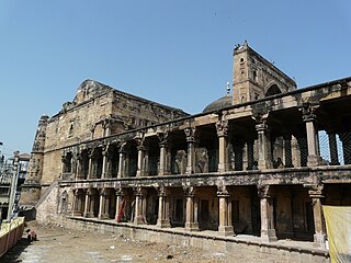
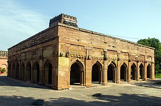
Sher Shah Suri, often called the "Just King", was the founder of the Sur Empire in India and Pakistan. He was the regent and later sole ruler of Bihar from 1529—1540 until he defeated the Mughal Empire in 1540, founding the Sur Empire, and establishing his rule in Delhi, crowning himself as Emperor. After his accidental death in 1545 CE, his son Islam Shah became his successor. The influence of his innovations and reforms extended far beyond his brief reign. In his reign, he remained undefeated in battle, being renowned as one of the most skillful Afghan generals ever produced.

<span class="mw-page-title-main">Jaunpur, Uttar Pradesh</span> City in Uttar Pradesh, India

Jaunpur is a city and a municipal board in Jaunpur district in the Indian state of Uttar Pradesh. It is located 228 km southeast of state capital Lucknow. Demographically, Jaunpur resembles the rest of the Purvanchal area in which it is located.

<span class="mw-page-title-main">Ghazipur</span> City in Uttar Pradesh, India

Ghazipur is a city in the state of Uttar Pradesh, India. Ghazipur city is the administrative headquarters of the Ghazipur district, one of the four districts that form the Varanasi division of Uttar Pradesh. The city of Ghazipur also constitutes one of the seven distinct tehsils, or subdivisions, of the Ghazipur district.

<span class="mw-page-title-main">Mau district</span> District in Uttar Pradesh, India

Mau district is one of the districts of Uttar Pradesh state of India, and Mau town is the district headquarters which is also one of the few remaining areas of handloom saree production in eastern Uttar Pradesh, specializing in Sadiya silk sarees. Mau was carved out as a separate district from Azamgarh on 19 November 1988. It is situated in the south-eastern part of the state with headquarters in Maunath Bhanjan. The district is surrounded by Ghazipur district on the south, Ballia district in the east, Azamgarh district in the west, and by Gorakhpur and Deoria districts on the north; says, Pallavi mishra.

<span class="mw-page-title-main">Shahjahanpur district</span> District of Uttar Pradesh in India

Shahjahanpur is a district of Uttar Pradesh India. It is a part of Bareilly division. It was established in 1813 by the British Government. Previously it was a part of district Bareilly. Geographically the main town is Shahjahanpur which is its headquarters. Its 4 Tehsils are: Powayan, Tilhar, Jalalabad and Sadar.

<span class="mw-page-title-main">Varanasi division</span> Administrative division of Uttar Pradesh, India

Varanasi division is one of the 18 administrative geographical units of the northern Indian state of Uttar Pradesh. Varanasi city is the administrative headquarters of the division. The division consists of 4 districts, i.e. Varanasi, Chandauli, Ghazipur, and Jaunpur and is loosely equivalent to the Benares State.

<span class="mw-page-title-main">Jaunpur district</span> District in Uttar Pradesh, India

Jaunpur district is a district in the Varanasi Division of the Indian state of Uttar Pradesh. The district headquarters is the city of Jaunpur which is situated on the banks of the Gomti River. It is located 228 km southeast of the state capital Lucknow. 65 km northwest of Varanasi and 732 km southeast of New Delhi. The district has two Lok Sabha seats and nine Vidhan Sabha seats. According to the 2011 census, Jaunpur has a gender ratio of 1,018 females to 1,000 males, the highest in Uttar Pradesh. The main languages spoken in the district is Hindi and Urdu.

<span class="mw-page-title-main">Bhadohi district</span> District in Uttar Pradesh, India

Bhadohi district is a district of Uttar Pradesh state in northern India. The city of Bhadohi is the district headquarters. Bhadohi is one of largest centres of Carpet Industries in India and is worldwide known as 'Carpet City of India'. Carpets of Bhadohi have 'Geographical Indication' tag attached to it. Bhadohi has huge geographical significance and position attached to it due to its location between two culturally important and rich heritage cities of Prayagraj and Varanasi.

<span class="mw-page-title-main">Chunar</span> City in Uttar Pradesh, India

Chunar is a city located in Mirzapur district of Indian state of Uttar Pradesh. It is nearby Mirzapur city. The railway tracks passing through Chunar Junction railway station leads to major destinations of India, including Howrah, Delhi, Tatanagar and Varanasi. National Highway 35 also passes through Chunar. It is connected to the city of Mirzapur and Varanasi by roads and rails. Chunar is well known for its handicraft products made from clay and plaster of paris. It is also famous for its historical place - Chunar Fort.

Gopamau is a town and nagar panchayat in Hardoi district, Uttar Pradesh, India. Located just west of the Gomti river, Gopamau is a historic town that once served as a pargana headquarters. Important industries include cap making, tobacco, and agricultural products. As of 2011, the population of Gopamau is 15,526, in 2,346 households. The town has several slum areas, which are home to 36.07% of town residents.

<span class="mw-page-title-main">Pihani</span> Town in Uttar Pradesh, India

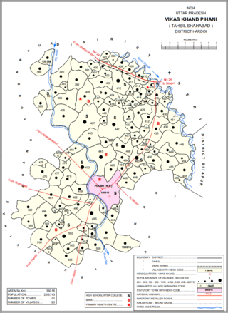
Pihani is a town and nagar palika parishad in Hardoi district of Uttar Pradesh, India. Historically, the city was a centre of sword production, leading to at least one British writer calling it "the Damascus of Oudh". Today, important industries in Pihani include jaggery and woven carpets. As of 2011, the town's population is 36,014, in 5,626 households. Pihani also serves as the headquarters of a community development block in Shahabad tehsil.

Shamsabad is a town and a nagar panchayat in Farrukhabad district in the Indian state of Uttar Pradesh.

Zamania is a town in the Indian state of Uttar Pradesh. Its municipal council is subordinate to the Ghazipur District.

<span class="mw-page-title-main">Benares State</span> Indian kingdom and later princely state (1740–1948)

Banaras State initially known as Banaras kingdom or Kashi Kingdom was a kingdom and later princely state under the Narayan Dynasty in what is today Uttar Pradesh, India. On 15 October 1948, Benares' last ruler signed the accession to the Indian Union.

<span class="mw-page-title-main">Jaunpur Sultanate</span> Medieval kingdom in India (c.1394–1479)

The Jaunpur Sultanate was an Indian Muslim state which ruled over much of what is now the states of Uttar Pradesh and Bihar between 1394 and 1494. It was founded in 1394 by Khwajah-i-Jahan Malik Sarwar, an eunuch slave and former wazir of Sultan Nasiruddin Muhammad Shah IV Tughluq, amidst the disintegration of the Delhi Sultanate's Tughlaq dynasty. Centred in Jaunpur, the Sultanate extended authority over a large part of the Ganges-Yamuna Doab. It reached its greatest height under the rule of Sultan Ibrahim Shah, who also vastly contributed to the development of Islamic education in the Sultanate. In 1494, Sultan Hussain Khan was defeated by the forces of the Afghan ruler Bahlul Lodi, Sultan of the Lodi dynasty of the Delhi Sultanate at Benares at which point Hussain fled to Kahalgaon in modern-day Bihar where the Sultan of Bengal assigned him a pargana. Here he was allowed to mint his own coins and was promised help from Bengal in recovering his kingdom. He died in 1505.

<span class="mw-page-title-main">Khardiha</span> Village in Uttar Pradesh, India

Khardiha is a village in the Karail area of the Mohammadabad tehsil in Ghazipur district, Uttar Pradesh, India. It has population of 1896 as per 2011 Census. It has its own local administration under Panchayati Raj system, with Gram Pradhan as head of local administration. Since the very beginning this village has been an important center of education and cultural activities.

Kundesar is a village in Ghazipur district, Uttar Pradesh. It has a population of 4602 per the 2011 Census. Having a history of five hundred years, this village has rich heritage of the Kinwar clan. Kundesar has got special mention in the gazetteers of Ghazipur since 1781. Kundesar is situated on the Ghazipur–Patna National Highway 19.

Gondaur is a village located in ‘Karail Kshetra’ of Mohammadabad tehsil of Ghazipur district, Uttar Pradesh. It had 590 families and a population of 3712 in the 2011 census.

<span class="mw-page-title-main">Bhojpur Kadim</span> Village in Bihar, India

Bhojpur Kadim is a historic village in Dumraon block of Buxar district, Bihar, India. As of 2011, its population was 18,243, in 3,024 households. Together with the neighboring Bhojpur Jadid, it lends its name to the surrounding Bhojpuri region.

References

  1. 1 2 3 4 5 6 7 8 "District Census Handbook: Ghazipur" (PDF). censusindia.gov.in. Registrar General and Census Commissioner of India. 2011.
  2. 1 2 3 4 5 6 7 "Uttar Pradesh District Gazetteers: Ghazipur".
  3. 1 2 3 4 5 6 7 ""Ghazipur That is known as Gadhipuri"".
  4. 1 2 3 4 5 "Evolution and Spatial Organization of Clan Settlements: A Case Study of Middle Ganga Valley".
  5. 1 2 3 4 5 6 "Ghazipur: A Gazetteer being Vol. XXIX of the District Gazetteers of the United Provinces of Agra and Oudh".
  6. Decadal Variation In Population Since 1901
  7. "Table C-01 Population by Religion: Uttar Pradesh". censusindia.gov.in. Registrar General and Census Commissioner of India. 2011.
  8. US Directorate of Intelligence. "Country Comparison:Population". Archived from the original on 13 June 2007. Retrieved 1 October 2011.
  9. "2010 Resident Population Data". U. S. Census Bureau. Archived from the original on 21 July 2011. Retrieved 30 September 2011. Oklahoma 3,751,351
  10. 1 2 "Table C-16 Population by Mother Tongue: Uttar Pradesh". www.censusindia.gov.in. Registrar General and Census Commissioner of India.
  11. Grierson, George Abraham (1881). A handbook to the Kayathi character. The Library of Congress. Calcutta, Thacker, Spink, and co.