
Meerut division is one of the 18 administrative geographical units (i.e. division) of the northern Indian state of Uttar Pradesh. Meerut city is the administrative headquarters of the division. It consists of 6 districts:-
Meerut division is one of the 18 administrative geographical units (i.e. division) of the northern Indian state of Uttar Pradesh. Meerut city is the administrative headquarters of the division. It consists of 6 districts:-
It is that area of Western Uttar Pradesh which is part of National Capital Region (NCR). All the districts, major cities and towns in this division are part of the NCR region of Uttar Pradesh. Ghaziabad, Noida were first to be added to NCR, later Meerut, Hapur, Muzaffarnagar, Bulandshahr and Baghpat were added. The region consists of nearly 37% of NCR area.
Higher government educational institutions in Meerut division are Chaudhary Charan Singh University (Meerut), LLRM Medical College (Meerut) and Gautam Buddha University (Greater Noida).
Division's official website is http://meerutdivision.nic.in/
28°59′24″N77°42′00″E / 28.9900°N 77.7000°E
| | This article about a location in Uttar Pradesh is a stub. You can help Wikipedia by expanding it. |

Noida, short for New Okhla Industrial Development Authority, is a city located in Gautam Buddha Nagar district of the Indian state of Uttar Pradesh. Noida is a satellite city of Delhi and is a part of the National Capital Region. As per provisional reports of Census of India, the population of Noida in 2011 was 642,381. The city is managed by New Okhla Industrial Development Authority (NOIDA). The district's administrative headquarters are in the nearby city of Greater Noida.

Harit Pradesh is a proposed new state of India comprising the western parts of Uttar Pradesh state. The etymology derives from harit, meaning 'green', and pradesh, meaning 'state'.

The National Capital Region is a planning region centered upon the National Capital Territory (NCT) of Delhi in India. It encompasses Delhi and several districts surrounding it from the states of Haryana, Uttar Pradesh, and Rajasthan. The NCR and the associated National Capital Region Planning Board (NCRPB) were created in 1985 to plan the development of the region and to evolve harmonized policies for the control of land-uses and development of infrastructure in the region. Prominent cities of NCR include Delhi, Faridabad, Ghaziabad, Gurgaon, Noida, Greater Noida, Meerut, Karnal, Bhiwadi, and YEIDA City.

Gautam Buddha Nagardistrict is a district of Uttar Pradesh, named after Gautama Buddha. It is a part of Delhi NCR and is divided into 3 sub-divisions (Tehsils) i.e. Noida, Dadri and Jewar. Greater Noida is the administrative headquarters of Gautam Buddha Nagar district. Noida, Greater Noida, Dadri, Jewar, YEIDA city and Dankaur fall under this district.
Hapur is a city in, as well as the headquarters of, Hapur district, in Uttar Pradesh, India. Located about 60 kilometres (37 mi) east of New Delhi, the city is part of the Delhi National Capital Region (NCR). National Highway 9 passes through the city, connecting it to Delhi.

Bulandshahr district is a district in the Meerut region in the North Indian state of Uttar Pradesh (UP), situated between the two rivers Ganga and Yamuna. It is a part of the National Capital Region of India, and Bulandshahr is the district headquarters.

Meerut district, is one of the districts of Uttar Pradesh state of India, and Meerut is the district headquarters. Meerut district is also a part of the Meerut division. The administrative head of district of Meerut is a District Magistrate while the administrative head of Meerut Division is Divisional Commissioner, an IAS officer.

Ghaziabad district is a largely suburban district of Uttar Pradesh state in northern India. It is also a core part of the National Capital Region. The city of Ghaziabad is the administrative headquarters of the district. This district is part of Meerut Division. It has become a major bedroom community for Delhi.
Behta Hajipur is a census town in the Loni block of Ghaziabad district in the Indian state of Uttar Pradesh. It is a part of the National Capital Region (NCR). At one end (southwest), the town's boundary terminates at National Highway 709B, which connects Delhi to Saharanpur, and at the other end (northeast), the boundary ends at Loni-Ghaziabad Road. It also share its territories with the neighboring census town, Mandoli.

Dadri is a town and a municipal board in Gautam Buddha Nagar District in the state of Uttar Pradesh, India. Noida, Dadri and Jewar are the 3 sub-divisions of GB Nagar district, each headed by a SDM.
Gulaothi is a town, near Bulandshahr city in the Bulandshahr district that falls under the Meerut division of the Indian state of Uttar Pradesh.
Jewar is a town and a nagar panchayat in Gautam Buddha Nagar district in the Indian state of Uttar Pradesh. Noida, Dadri and Jewar are the 3 sub-divisions of GB Nagar district, each headed by a SDM.
Jalalabad (Jalālābād) is a town and a nagar panchayat in Shamli district in the Indian state of Uttar Pradesh. It is a historical town situated on Delhi Saharanpur road. Dating back to the Mughal period, situated close to the borders of Haryana and Uttarakhand states, and surrounded by a very fertile agricultural region namely famous for plentiful yields in grains and fruits, Jalalabad is internationally famous for its wood carving work cottage industry. It is a thriving market of local agricultural produce, including basmati rice and mangoes. A variety of agro-based industrial enterprises - such as textile, sugar, paper and cigarette factories - are located around it. It is 41 km from Saharanpur and 40 km from Muzaffarnagar.
Loni is a town, near Ghaziabad city in Ghaziabad district in the state of Uttar Pradesh, India and Loni town is governed by Loni Municipal Council which comes under Ghaziabad Metropolitan Region.

Uttar Pradesh is the most populous state in India with a population of nearly 240 million people. The economy of Uttar Pradesh is the third largest among states in India. At current prices, the gross state domestic product (GSDP) of Uttar Pradesh is estimated to be Rs. 25.56 trillion in 2023–24. Merchandise exports from Uttar Pradesh reached US$21.03 billion in FY22.
Gautam Buddha Nagar Lok Sabha constituency is one of the 80 Lok Sabha (parliamentary) constituencies in Uttar Pradesh state in northern India. This constituency, spread over Bulandshahr and Gautam Buddha Nagar districts came into existence in 2008 as a part of the implementation of delimitation of parliamentary constituencies based on the recommendations of the Delimitation Commission of India constituted in 2002.

Western Uttar Pradesh is a region in India that comprises the western districts of Uttar Pradesh state, including the areas of Rohilkhand and those where Khariboli, Braj and Kannauji are spoken. The region has some demographic, economic and cultural patterns that are distinct from other parts of Uttar Pradesh, and more closely resemble those of Haryana and Rajasthan states. Western Uttar Pradesh has experienced rapid economic growth, in a fashion similar to Haryana and Punjab, due to the successes of the Green Revolution. A significant part of western Uttar Pradesh is a part of National Capital Region of India. The largest city of the region is Ghaziabad, while the second-largest city, Agra, is a major tourist destination.

Hapur district is a recently formed district in the Indian state of Uttar Pradesh with a population of 1,338,211 at the 2011 Census. It arose as an area leading in the trade of grains and jaggery. This district on the Ganges river is 60 kilometres (37 mi) from New Delhi. Being located on the river could be a reason for its prosperity in trade.It is the smallest district of Uttar Pradesh.
Satha Chaurasi refers to an area in the west of the Indian state of Uttar Pradesh, where the majority population belongs to the members of the Rajputs (Thakur) community. It falls within the boundaries of the Ghaziabad, Meerut and Muzaffarnagar Lok Sabha constituencies. Satha translates as group of sixty and chaurasi as group of eighty-four. These numbers may have had a significant socio-political context in the medieval period as a definition of scope for territorial and lineal boundaries.
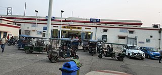
Hapur Junction railway station is the main railway station serving Hapur city in the Hapur district, Uttar Pradesh. Its code is HPU. The station consists of five platforms. Hapur is a major railway junction of northern India. Two lines – Delhi–Moradabad and Meerut–Bulandshahr–Khurja – pass through the city.