Related Research Articles

Braddock Heights is an unincorporated community and census-designated place (CDP) in Frederick County, Maryland, United States. The population was 2,608 at the 2010 census. The local ZIP codes are 21714 and 21703.

Thurmont is a town in Frederick County, Maryland, United States. The population was 6,170 at the 2010 census. The town is located in the northern part of Frederick County, approximately ten miles from the Pennsylvania border, along U.S. Highway 15. It is very close to Cunningham Falls State Park and Catoctin Mountain Park, the latter of which contains the presidential retreat of Camp David. Thurmont is also home to Catoctin Colorfest, an arts and crafts festival that draws in about 125,000 people each autumn.

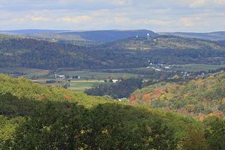
Catoctin Mountain Park, located in north-central Maryland, is part of the forested Catoctin Mountain ridge−range that forms the northeastern rampart of the Blue Ridge Mountains, in the Appalachian Mountains System.

Catoctin Creek is a 27.9-mile-long (44.9 km) tributary of the Potomac River in Frederick County, Maryland, USA. Its source is formed in the Myersville, Maryland area and flows directly south for the entire length of the stream. Catoctin Creek enters the Potomac River east of Brunswick. The stream flows through Catoctin Creek Park.

Taylorstown is a small community in Loudoun County, Virginia, built on the banks of Catoctin Creek and the surrounding hillside, about two miles (3 km) south of the Potomac River. First settled in 1734, it holds two of the oldest standing houses in Loudoun County, "Hunting Hill" and "Foxton Cottage", directly across the Catoctin Creek from each other.

Catoctin Quaker Camp (CQC) is a small Quaker residential-wilderness summer camp located near Frederick, Maryland operated by Baltimore Yearly Meeting. It caters to both Quaker and non-Quaker children between the ages of 9–14, organizing them by age into "units," or groups of campers who share cabins and go on trips together. During their time at camp — two to four weeks — children are taught Quaker values of simplicity, equality, and peace, and the benefits of living in an intentional, child-centered, loving community.
Bonawe is a village in Ardchattan Parish Argyll and Bute, Scotland opposite Taynuilt on the north shore of Loch Etive, most famous for the shipping firm J & A Gardener's Bonawe Quarry - now owned by Breedon Aggregates Scotland Ltd. Bonawe is primarily a linear settlement along on the B845 road and the coast. The iron furnace is in Taynuilt

Tahawus was a village in the Town of Newcomb, Essex County, New York, United States. It is now a ghost town situated in the Adirondack Park. Tahawus is located in Essex County within the unpopulated northern area designated to the town of Newcomb. Tahawus was the site of major mining and iron smelting operations in the 19th century. Although standing as recently as 2005, the last mining facilities have since been demolished and removed.
Scotia was a village in Patton Township, Centre County, Pennsylvania, at 40°47′59″N77°56′46″W. Although the community was called Scotia, the name of the local post office was Benore.
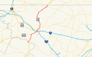
U.S. Route 15 (US 15) is a part of the U.S. Highway System that runs from Walterboro, South Carolina to Painted Post, New York. In Maryland, the highway runs 37.85 miles (60.91 km) from the Virginia state line at the Potomac River in Point of Rocks north to the Pennsylvania state line near Emmitsburg. Known for most of its length as Catoctin Mountain Highway, US 15 is the primary north–south highway of Frederick County. The highway connects the county seat of Frederick with Point of Rocks, Leesburg, Virginia, and Charles Town, West Virginia, to the south and with Thurmont, Emmitsburg, and Gettysburg, Pennsylvania, to the north. US 15 is a four-lane divided highway throughout the state except for the portion between the Point of Rocks Bridge and the highway's junction with US 340 near Jefferson. The U.S. Highway is a freeway along its concurrency with US 340 and through Frederick, where the highway meets US 40 and Interstate 70 (I-70). US 15 has an unsigned business route through Emmitsburg.
Graysdale is an unincorporated community in Patton Township, Centre County, Pennsylvania, located at 40.8130°N 77.9548°W.
Little Catoctin Creek is an 8.5-mile-long (13.7 km) tributary of the Potomac River in Frederick County, Maryland. The creek starts south of Burkittsville and flows to the southeast, passing north of Brunswick before emptying into the Potomac west of Lander.

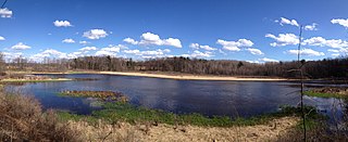
Cunningham Falls State Park is a public recreation area located west of Thurmont, Maryland, in the United States. The state park is the home of Cunningham Falls, the largest cascading waterfall in Maryland, a 43-acre (17 ha) man-made lake, and the remains of a historic iron furnace. The park is one of several protected areas occupying 50-mile-long Catoctin Mountain; it is bordered on its north by Catoctin Mountain Park and on its south by Frederick Municipal Forest.
Oreton is a ghost town in eastern Vinton Township, Vinton County, Ohio, United States, located along State Route 160. Oreton was a small mining community. Today, all that remains are the crumbled ruins of the iron furnace, a few concrete foundations, and the brick safe of Dave Ebert's company store.
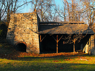
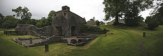
Catoctin Furnace is a historic iron forge located on Route 15 between Frederick and Thurmont in Catoctin Furnace, Maryland. The smelting blast furnace is shown. No forge is at the site now. Forges were present when the ironworks was operational.
The Catoctin AVA is an American Viticultural Area located in the Frederick and Washington counties of western Maryland. The region is bordered by Catoctin Mountain to the east, the Pennsylvania border to the north, South Mountain to the west, and the Potomac River to the south. "Catoctin" is Algonquian for "speckled rock", a geological feature of the area. Two commercial wineries operate in the AVA. The hardiness zones are 7a and 6b.
Ballenger Creek is a 10.7-mile-long (17.2 km) tributary of the Monocacy River in Frederick County, Maryland. The headwaters of the creek are located on the east slope of Catoctin Mountain, about 3 miles (5 km) west of the city of Frederick. The stream runs roughly southeast to the Monocacy National Battlefield and the confluence with the Monocacy River, which drains to the Potomac River. The watershed area of the creek is 21.8 square miles (56 km2).
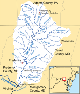
Linganore Creek is a 13.5-mile-long (21.7 km) tributary of the Monocacy River in Frederick County, Maryland. The stream is formed from the confluence of the north and south forks of the Linganore, about 10 miles (16 km) east-northeast of the city of Frederick. The creek runs roughly southwest to the Monocacy River, which drains to the Potomac River. The watershed area of the creek is 83.1 square miles (215 km2). High water in the creek can result in flooding of Gas House Pike, an east-west road running between Monocacy Boulevard and Green Valley Road.
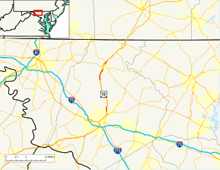
Maryland Route 806 is a state highway in the U.S. state of Maryland. The state highway runs a total of 4.05 miles (6.52 km) in two segments from U.S. Route 15 near Catoctin Furnace north to Roddy Creek Road near Thurmont. MD 806A, which has a length of 3.04 miles (4.89 km) from Catoctin Furnace to Thurmont, and MD 806R, which extends 0.55 miles (0.89 km) on the north side of Thurmont, are separated by a section of municipally-maintained road on the south side of Thurmont and a segment of MD 550 north of MD 77. MD 806 is the old alignment of US 15 through Catoctin Furnace and Thurmont. The state highway was originally constructed in the 1910s. MD 806 was assigned to the highway when US 15 bypassed Thurmont in the late 1950s. The state highway became a split route in the late 1980s. There have been several other segments of MD 806 along former sections of US 15 in Frederick County, including portions around Lewistown and south of Frederick.
Tuscarora Creek is a 7.7-mile-long (12.4 km) tributary of the Monocacy River in Frederick County, Maryland, in the United States.
References
- ↑ "Geographic Names Information System". Catoctin Furnace(Populated Place). U.S. Geological Survey. 2009-01-29.
| Wikimedia Commons has media related to Catoctin Furnace, Maryland . |
Municipalities and communities of Frederick County, Maryland, United States | ||
|---|---|---|
| Cities |  | |
| Towns | ||
| Village | ||
| CDPs | ||
| Other communities |
| |
| Footnotes | ‡This populated place also has portions in an adjacent county or counties | |