Green Valley, Maryland

Last updated

Green Valley, Maryland
Frederick County Maryland Incorporated and Unincorporated areas Green Valley Highlighted.svg
Location of Green Valley, Maryland
Coordinates: 39°20′30″N77°15′02″W / 39.34167°N 77.25056°W / 39.34167; -77.25056
CountryFlag of the United States.svg  United States
State Flag of Maryland.svg  Maryland
County Flag of Frederick County, Maryland.svg Frederick
Area
[1]
  Total17.13 sq mi (44.37 km2)
  Land17.09 sq mi (44.28 km2)
  Water0.04 sq mi (0.09 km2)
Elevation
[2]
653 ft (199 m)
Population
 (2020)
  Total12,643
  Density739.57/sq mi (285.54/km2)
Time zone UTC−5 (Eastern (EST))
  Summer (DST) UTC−4 (EDT)
FIPS code 24-35412
GNIS feature ID2806298 [2]

Green Valley is an unincorporated area and census-designated place (CDP) in southern Frederick County, Maryland, United States. The population was 12,643 at the 2020 census. [3] The area was listed as a census-designated place in 2000 but not listed as part of any CDP at the 2010 census. It was re-designated a census-designated place for the 2020 census.

Contents

Geography

The Green Valley area is located in southeastern Frederick County at 39°20′30″N77°14′26″W / 39.34167°N 77.24056°W / 39.34167; -77.24056 (39.341801, 77.240437), [4] bordered to the south and east by Montgomery County. The northern edge of the CDP extends from Mount Airy in the northeast to New Market in the northwest. The unincorporated community of Monrovia is located just to the west.

According to the United States Census Bureau, the Green Valley CDP had a total area of 20.6 square miles (53 km2), all land.

Demographics

Historical population
CensusPop.Note
2000 12,262
2020 12,643
U.S. Decennial Census [5]
2020 [6]

2020 census

Green Valley CDP, Maryland - Demographic Profile
(NH = Non-Hispanic)
Race / EthnicityPop 2020 [6] % 2020
White alone (NH)10,46382.54%
Black or African American alone (NH)2972.35%
Native American or Alaska Native alone (NH)180.14%
Asian alone (NH)3843.04%
Pacific Islander alone (NH)10.01%
Some Other Race alone (NH)580.46%
Mixed Race/Multi-Racial (NH)5994.74%
Hispanic or Latino (any race)8506.72%
Total12,643100.00%

Note: the US Census treats Hispanic/Latino as an ethnic category. This table excludes Latinos from the racial categories and assigns them to a separate category. Hispanics/Latinos can be of any race.

2000 Census

As of the census [7] of 2000, there were 12,262 people, 3,882 households, and 3,470 families residing in the CDP. The population density was 595.1 inhabitants per square mile (229.8/km2). There were 3,928 housing units at an average density of 190.6 per square mile (73.6/km2). The racial makeup of the CDP was 95.91% White, 1.24% African American, 0.23% Native American, 0.99% Asian, 0.04% Pacific Islander, 0.38% from other races, and 1.22% from two or more races. Hispanic or Latino of any race were 1.69% of the population.

There were 3,882 households, out of which 49.1% had children under the age of 18 living with them, 81.7% were married couples living together, 4.6% had a female householder with no husband present, and 10.6% were non-families. 7.8% of all households were made up of individuals, and 2.8% had someone living alone who was 65 years of age or older. The average household size was 3.16 and the average family size was 3.33.

In the CDP, the population was spread out, with 31.2% under the age of 18, 5.6% from 18 to 24, 30.0% from 25 to 44, 27.5% from 45 to 64, and 5.7% who were 65 years of age or older. The median age was 37 years. For every 100 females, there were 102.6 males. For every 100 females age 18 and over, there were 100.6 males.

The median income for a household in the CDP was $81,732, and the median income for a family was $84,607. Males had a median income of $53,482 versus $37,726 for females. The per capita income for the CDP was $29,408. About 1.9% of families and 2.1% of the population were below the poverty line, including 1.4% of those under age 18 and 0.4% of those age 65 or over.

Related Research Articles

<span class="mw-page-title-main">Brooklyn Park, Maryland</span> Census-designated place in Maryland, United States

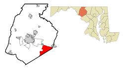
Brooklyn Park is a census-designated place (CDP) in Anne Arundel County, Maryland, United States. The population was 14,373 at the 2010 census.

<span class="mw-page-title-main">Garrison, Maryland</span> Census-designated place in Maryland, United States

Garrison is a census-designated place (CDP) in Baltimore County, Maryland, United States, adjacent to Owings Mills. It consists mainly of the McDonogh area and Valley Centre. The population was 8,823 at the 2010 census.

<span class="mw-page-title-main">Lochearn, Maryland</span> Census-designated place in Maryland, United States

Lochearn is an unincorporated community and census-designated place in Baltimore County, Maryland, United States, located immediately to the west of the City of Baltimore. Per the 2020 census, the population was 25,511.

<span class="mw-page-title-main">Milford Mill, Maryland</span> Census-designated place in Maryland, United States

Milford Mill is an unincorporated community and census-designated place in Baltimore County, Maryland, United States. Per the 2020 census, the population was 30,622.

<span class="mw-page-title-main">Randallstown, Maryland</span> Census-designated place in Maryland, United States

Randallstown is an unincorporated community and census-designated place in Baltimore County, Maryland, United States. It is named after Christopher and Thomas Randall, two 18th-century tavern-keepers. At that time, Randallstown was a tollgate crossroads on the Liberty Turnpike, a major east–west thoroughfare. It is a suburb of Baltimore, with a population of 33,655 as of the 2020 census. As of 2020 it was 72 percent African American. In the 1990s, Randallstown transitioned to a majority African American community.

<span class="mw-page-title-main">Bennsville, Maryland</span> Census-designated place in Maryland, United States

Bennsville is a census-designated place (CDP) in Charles County, Maryland, United States. Per the 2020 census, the population was 15,288. The area is not an official postal designation, but is part of the Waldorf or Pomfret postal area. The Bennsville area is growing with new residential development, encouraged by the extension in the 1990s of Maryland Route 228 which provides quick access to Maryland Route 210. Bennsville has experienced the 2006 opening of North Point High School and the straightening of Middletown Road in 2008.

<span class="mw-page-title-main">Fairland, Maryland</span> Census-designated place in Maryland, United States

Fairland is a census-designated place and an unincorporated area in Montgomery County, Maryland, United States. It had a population of 25,396 per the 2020 census.

<span class="mw-page-title-main">Friendly, Maryland</span> Census-designated place in Maryland

Friendly is an unincorporated area and census-designated place (CDP) in Prince George's County, Maryland, United States, with an African-American majority population, located a few miles south of Washington, D.C. The population was 9,937 at the 2020 census.

<span class="mw-page-title-main">South Laurel, Maryland</span> Census-designated place in Maryland

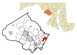
South Laurel is an unincorporated area and census-designated place (CDP) in Prince George's County, Maryland, United States. Per the 2020 census, the population was 29,602.

<span class="mw-page-title-main">Cavetown, Maryland</span> CDP in Maryland, United States

Cavetown is a census-designated place (CDP) in Washington County, Maryland, United States. The population was 1,486 at the 2000 census.

<span class="mw-page-title-main">Fountainhead-Orchard Hills, Maryland</span> CDP in Maryland, United States

Fountainhead-Orchard Hills is a census-designated place (CDP) in Washington County, Maryland, United States. The population was 3,861 at the 2000 census.

<span class="mw-page-title-main">Halfway, Maryland</span> CDP in Maryland, United States

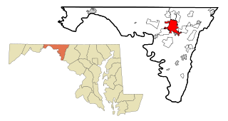
Halfway is a census-designated place (CDP) in Washington County, Maryland, United States. The population was 11,896 at the 2020 census. It is named due to its location, which is Halfway Between Hagerstown & Williamsport. As a major suburb of Halfway is part of the Hagerstown-Martinsburg, MD-WV, Metropolitan Statistical Area.

<span class="mw-page-title-main">Highfield-Cascade, Maryland</span> CDP in Maryland, United States

Highfield-Cascade is a census-designated place (CDP) in Washington County, Maryland, United States. The CDP is, however, more commonly referred to as just Cascade, MD. The official CDP name encompasses two closely-spaced unincorporated communities, Highfield and Cascade. The population of the CDP was 1,141 at the 2000 census.

<span class="mw-page-title-main">Leitersburg, Maryland</span> Place in Maryland, United States

Leitersburg is a census-designated place (CDP) in Washington County, Maryland, United States. The population was 523 at the 2000 census.

<span class="mw-page-title-main">Maugansville, Maryland</span> CDP in Maryland, United States

Maugansville is a census-designated place (CDP) in Washington County, Maryland, United States. The population was 2,295 at the 2000 census.

<span class="mw-page-title-main">Mount Lena, Maryland</span> CDP in Maryland, United States

Mount Lena is a census-designated place (CDP) in Washington County, Maryland, United States. The population was 501 at the 2000 census.

<span class="mw-page-title-main">Robinwood, Maryland</span> CDP in Maryland, United States

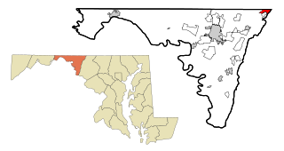
Robinwood is a census-designated place (CDP) in Washington County, Maryland, United States. The population was 4,731 at the 2000 census. It is a part of the Hagerstown Metropolitan Area. Robinwood is home to Hagerstown Community College.

<span class="mw-page-title-main">San Mar, Maryland</span> CDP in Maryland, United States

San Mar is a census-designated place (CDP) in Washington County, Maryland, United States. The population was 515 at the 2000 census.

<span class="mw-page-title-main">St. James, Maryland</span> CDP in Maryland, United States

St. James is a census-designated place (CDP) in Washington County, Maryland, United States. The population was 1,657 at the 2000 census. It is also the home of St. James School, Hagerstown, a small, Episcopalian, boarding school. St. James was formerly named "Lydia."

<span class="mw-page-title-main">Green Valley, South Dakota</span> CDP in South Dakota, United States

Green Valley is a census-designated place (CDP) and unincorporated community in Pennington County, South Dakota, United States. The population was 1,051 at the 2020 census.

References

  1. "2020 U.S. Gazetteer Files". United States Census Bureau. Retrieved April 26, 2022.
  2. 1 2 U.S. Geological Survey Geographic Names Information System: Green Valley, Maryland
  3. "Green Valley CDP, Maryland". United States Census Bureau . Retrieved March 13, 2022.
  4. "US Gazetteer files: 2010, 2000, and 1990". United States Census Bureau. February 12, 2011. Retrieved April 23, 2011.
  5. "Decennial Census of Population and Housing by Decades". US Census Bureau.
  6. 1 2 "P2 HISPANIC OR LATINO, AND NOT HISPANIC OR LATINO BY RACE - 2020: DEC Redistricting Data (PL 94-171) - Green Valley CDP, Maryland". United States Census Bureau .
  7. "U.S. Census website". United States Census Bureau . Retrieved January 31, 2008.