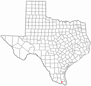
Santa Rosa is a town in Cameron County, Texas, United States. The population was 2,873 at the 2010 census. It is part of the Brownsville–Harlingen–Raymondville and the Matamoros–Brownsville metropolitan areas.

Perkinsville is a locale in Steuben County in the U.S. state of New York. It is the birthplace of Patty Maloney. It is located at 42°32′23″N77°37′41″W. As of the 2000 U.S. census, Perkinsville has an average household size of 2.66 persons.
Beechmount is a suburb of Edinburgh, the capital of Scotland. It is south of the A8.
Fairhaven is an unincorporated community in eastern Israel Township, Preble County, Ohio, United States. It lies along State Route 177 at its intersection with Israel-Somers Road. Four Mile Creek, which feeds into Acton Lake in southern Preble County, runs on the western edge of Fairhaven. It is located 10½ miles southwest of Eaton, the county seat of Preble County.The community is part of the Dayton Metropolitan Statistical Area. Fairhaven Church and Fairhaven Community Church are both located in Fairhaven along State Route 177. Fairhaven Community Church hosts a free anual Dinner Drama for the community. Fairhaven is home to the historic Bunker Hill house, a stop along the Underground Railroad.
Emit is an unincorporated community in Johnston County, North Carolina, at the intersection of North Carolina Highway 39 and North Carolina Highway 231. It lies at an elevation of 285 feet.
Nash Corner is an unincorporated community in Accomack County, Virginia.
Caskie is an unincorporated community in Nelson County, Virginia, United States.

Qarğabazar is a village in the Fizuli Rayon of Azerbaijan. It is located in the southern part of Füzuli city, at the foot of Ilanlidag Mountain, at a height of 460 meters. Since 1993, the village is under the control of unrecognized Nagorno-Karabakh Republic.

Fairhaven is an unincorporated community retirement community in Carroll County, Maryland, United States.

Ingle is an unincorporated community in Fresno County, California. It is located on the Southern Pacific Railroad 7.25 miles (11.7 km) east-southeast of Mendota, at an elevation of 164 feet.
18 Mile House is a former settlement in Kern County, California. It was located just south of Cinco.
Läkumätas is an island in Lääne-Saare Parish, Saare County, Estonia.

Merom Station is an unincorporated community in Gill Township, Sullivan County, in the U.S. state of Indiana.

Jessup or Jessups Station is an unincorporated community in Florida Township, Parke County, in the U.S. state of Indiana.
Clopton is an unincorporated community in Gloucester County, in the U. S. state of Virginia.
York River Farms is an unincorporated community in Gloucester County, in the U. S. state of Virginia.

StreetMekka is a 2,200 square metre indoor venue for street sports and street culture in the Kongens Enghave district of Copenhagen, Denmark. The activities include Street basketball, parkour, dance, street soccer, street art, beat production, and DJ'ing. It is situated at Enghavevej 82 D, adjacent to Copenhagen Skatepark.

Skafida Peak is the peak rising to 2100 m near the north end of the main ridge of Sentinel Range in Ellsworth Mountains, Antarctica. It has steep and partly ice-free east and south slopes, and surmounts Newcomer Glacier to the east. The peak is named after the medieval fortress of Skafida in Southeastern Bulgaria.
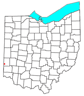
Klocks Crossing is an unincorporated community in Clinton County, in the U.S. state of Ohio.
Masarrochos is a village in the district Pobles del Nord in the municipality of Valencia. The locality has a population of 2,319.