Frederick County is located in the northern part of the U.S. state of Maryland. As of the 2010 U.S. Census, the population was 240,336. The county seat is Frederick.

Washington County is located in the western part of the U.S. state of Maryland. As of the 2010 census, the population was 147,430. Its county seat is Hagerstown. Washington County was the first county in the United States to be named for the Revolutionary War general George Washington. Washington County is one of three Maryland counties recognized by the Appalachian Regional Commission as being part of Appalachia.

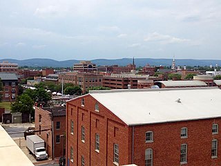
Frederick is a city in, and the county seat, of Frederick County in the U.S. state of Maryland. It is part of the Baltimore–Washington Metropolitan Area. Frederick has long been an important crossroads, located at the intersection of a major north–south Indian trail and east–west routes to the Chesapeake Bay, both at Baltimore and what became Washington, D.C. and across the Appalachian mountains to the Ohio River watershed. It is a part of the Washington-Arlington-Alexandria, DC-VA-MD-WV Metropolitan Statistical Area, which is part of a greater Washington-Baltimore-Arlington, DC-MD-VA-WV-PA Combined Statistical Area. The city's population was 65,239 people at the 2010 United States Census, making it the second-largest incorporated city in Maryland, behind Baltimore. Frederick is home to Frederick Municipal Airport, which accommodates general aviation, and to the county's largest employer U.S. Army's Fort Detrick bioscience/communications research installation.

Catonsville is a census-designated place (CDP) in Baltimore County, Maryland, United States. The population was 41,567 at the 2010 census. The community lays to the west of Baltimore along the city's border. Catonsville contains the majority of the University of Maryland, Baltimore County (UMBC), a major public research university with close to 14,000 students.

Thurmont is a town in Frederick County, Maryland, United States. The population was 6,170 at the 2010 census. The town is located in the northern part of Frederick County, approximately ten miles from the Pennsylvania border, along U.S. Highway 15. It is very close to Cunningham Falls State Park and Catoctin Mountain Park, the latter of which contains the presidential retreat of Camp David. Thurmont is also home to Catoctin Colorfest, an arts and crafts festival that draws in about 125,000 people each autumn.

Jefferson is an unincorporated community and census-designated place (CDP) in Frederick County, Maryland, United States. As of the 2010 census it had a population of 2,111. It was established in 1774 and incorporated as a town in 1831. However, a year later, in 1832, the citizens of the town decided that municipal government was unnecessary, and disincorporated the town.
Fort Frederick State Park is a public recreation and historic preservation area on the Potomac River surrounding the restored Fort Frederick, a stone fort active in the French and Indian War (1754–1763) and the American Revolutionary War (1775-1783). The state park lies south of the town of Big Pool, Maryland. The Chesapeake and Ohio Canal runs through the park grounds. The site was designated a National Historic Landmark in 1973.

Woodbine is an unincorporated rural community in Howard and Carroll counties, Maryland, United States. It is part of the Baltimore metropolitan area. It is located southeast of Frederick, west of Baltimore, north of Washington, D.C., and east of Mount Airy. The community was named for the woodbine plant, which grew in the community in fields and along riverbanks.

Maryland Route 355 (MD 355) is a 36.75-mile (59.14 km) north–south road in western central Maryland in the United States. The southern terminus of the route, Wisconsin Avenue, is located in the Bethesda CDP, at the Washington, D.C. border. It continues south into Washington, D.C. as Wisconsin Avenue NW. The northern terminus is just north of an overpass with Interstate 70 (I-70) and U.S. Route 40 (US 40) in the city of Frederick in Frederick County, where the road continues north as Market Street through Frederick towards MD 26.
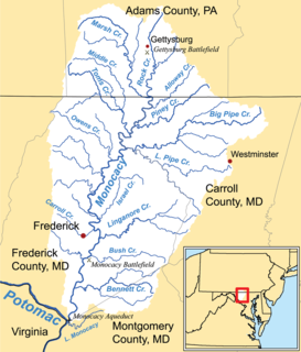
Middle Creek is a 17.1-mile-long (27.5 km) tributary of Toms Creek in Pennsylvania and Maryland in the United States.
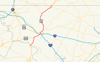
U.S. Route 15 (US 15) is a part of the U.S. Highway System that runs from Walterboro, South Carolina to Painted Post, New York. In Maryland, the highway runs 37.85 miles (60.91 km) from the Virginia state line at the Potomac River in Point of Rocks north to the Pennsylvania state line near Emmitsburg. Known for most of its length as Catoctin Mountain Highway, US 15 is the primary north–south highway of Frederick County. The highway connects the county seat of Frederick with Point of Rocks, Leesburg, Virginia, and Charles Town, West Virginia, to the south and with Thurmont, Emmitsburg, and Gettysburg, Pennsylvania, to the north. US 15 is a four-lane divided highway throughout the state except for the portion between the Point of Rocks Bridge and the highway's junction with US 340 near Jefferson. The U.S. Highway is a freeway along its concurrency with US 340 and through Frederick, where the highway meets US 40 and Interstate 70 (I-70). US 15 has an unsigned business route through Emmitsburg.

This is a list of the National Register of Historic Places listings in Frederick County, Maryland.

Croom is an unincorporated community and census-designated place in Prince George's County, Maryland, United States. As of the 2010 census it had a population of 2,631. Croom largely consists of former tobacco farms and forests converted to Washington bedroom subdivisions such as nearby Marlton. The main part of Patuxent River Park is in Croom.

Johnsville is an unincorporated community in Frederick County, Maryland, United States.
Friendship is an unincorporated community and census-designated place (CDP) in Anne Arundel County, Maryland, United States. As of the 2010 census, its population was 447.

Tuscarora Creek is a 12.8-mile-long (20.6 km) tributary of the Potomac River in Frederick County, Maryland, in the United States.
Wilson is an unincorporated community in Calvert County, Maryland, United States. Wilson is located along Wilson Road near the Chesapeake Bay, 5.5 miles (8.9 km) northeast of Prince Frederick.
Discovery is an unincorporated community in St. Mary's County, Maryland, United States. Discovery is located near Maryland Route 235, northwest of Lexington Park and southeast of California.
Garfield is an unincorporated community in Frederick County, Maryland, United States, situated within the District 6, Catoctin. It has an elevation of 1,453 feet (443 m).
New Market West is a suburban housing community in Frederick County, in the U.S. state of Maryland. The community is located in the foothills of the Blue Ridge Mountains and is adjacent to the town of New Market.

