
Rohrersville is a census-designated place (CDP) in Washington County, Maryland, United States. The population was 175 at the 2010 census.

Darlington is an unincorporated community and census-designated place in northeastern Harford County, Maryland, United States. The population was 409 at the 2010 census. The center of the community was listed on the National Register of Historic Places as the Darlington Historic District in 1987. Median household income is $66,563. The percentage of people in poverty is 5.3%.

Buckeystown is an unincorporated community and census-designated place (CDP) in Frederick County, Maryland, United States. As of the 2010 census the population was 1,019. Buckeystown Historic District and Buckingham House and Industrial School Complex were listed on the National Register of Historic Places in 1982. Carrollton Manor was listed in 1997. Former Congressman Roscoe Bartlett lives on a farm in the town.

Norton is an unincorporated community located within Union Township, in Hunterdon County, New Jersey. Norton is located on County Route 635, approximately 1.5 mi (2.4 km) northwest of Interstate 78. The village is included in the Van Syckel Corner District, which was added to the National Register of Historic Places in 1979.
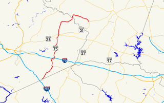
Maryland Route 75 is a state highway in the U.S. state of Maryland. Known for most of its length as Green Valley Road, the state highway runs 28.40 miles (45.71 km) from MD 355 near Hyattstown north to MD 31 in New Windsor. MD 75 serves as the main north–south highway of eastern Frederick County, where it connects Hyattstown with New Market, Libertytown, Johnsville, and the Carroll County town of Union Bridge. The first sections of MD 75 were constructed around New Windsor and between Green Valley and New London in the early 1910s. The latter highway was extended south to Green Valley in the late 1910s. In the early 1920s, MD 75 was constructed between New Windsor and Union Bridge and from Libertytown to Johnsville. The remainder of the state highway was constructed in the late 1920s and early 1930s. MD 75 was relocated between Union Bridge and New Windsor in the early 1960s, around its interchange with Interstate 70 (I-70) and U.S. Route 40 in New Market in the early 1970s, and at its northern terminus in New Windsor in 2007.
Long Green is an unincorporated community in Baltimore County, Maryland, United States. Until 1958, the community was served by the Maryland and Pennsylvania Railroad at milepost 15.8. Prospect Hill was listed on the National Register of Historic Places in 1973.

Fairmount is an unincorporated community located along County Route 517 in Tewksbury Township of Hunterdon County, New Jersey. The community was first known as Parkersville, named after proprietor James Parker (1725–1797). The southern section of the community is known as Lower Fairmount.

Geeting Farm is a historic home located at Keedysville, Washington County, Maryland, United States. It is a two-story, five-bay log dwelling resting on low fieldstone foundations, with a one-story, three-bay stone addition. Numerous sheds and outbuildings are located near the house. The house was built by George Adam Geeting [1741-1812], who settled on this land near Little Antietam Creek after immigrating to the English Colony of Maryland in 1759 from his native Prussia. Geeting farmed his land and taught in a log schoolhouse nearby which became a regular preaching appointment for services held by Rev. Philip William Otterbein, one of the founding leaders of the United Brethren in Christ, the first denomination organized in the United States of America. In the mid-1770s, Geeting erected a meetinghouse which later became known as Mount Hebron Church, the first structure built expressly for services of the future United Brethren in Christ denomination. Salem United Methodist Church in Keedysville is the successor to the Mount Hebron Church and Geeting Meetinghouse. Getting himself was ordained a minister of the German Reformed Church in 1788 and traveled extensively through Western Maryland, Virginia, and Pennsylvania as an itinerant preacher. On September 25, 1800, George Adam Geeting attended the first conference of the United Brethren in Christ at the home of Peter Kemp near Frederick, Maryland. It was at this conference that the United Brethren in Christ was formally organized as a denomination and took its name. Geeting continued serving as a minister for the new church, acted as secretary of the denominational conference, and served as a bishop of the United Brethren in Christ briefly in 1812 before his death.

Rocky Ridge is an unincorporated community in Frederick County, Maryland, United States. The name "Rocky Ridge" likely refers to a ridge of ironstone which runs through the area.

Sabillasville is an unincorporated community and census-designated place in Frederick County, Maryland, United States. As of the 2010 census it had a population of 354.

Knoxville is an unincorporated community in Frederick and Washington counties, Maryland, United States. The Robert Clagett Farm and Magnolia Plantation are listed on the National Register of Historic Places.

Ijamsville is an unincorporated community located 7 miles (11 km) southeast of Frederick, in Frederick County, Maryland, United States. The town was founded by Plummer Ijams, a descendant of Welsh immigrants, from whom the town took its name. The discovery of high-quality slate in the area led to Ijamsville's brief era as a mining town, which lasted until its transition to agriculture in the mid-1800s. In the mid-to-late 20th century, large quantities of land in Ijamsville were purchased by developers, and the town became primarily residential as a suburb of Frederick, Baltimore, and D.C..
Wolfsville is an unincorporated community in Frederick County, Maryland, United States. Situated in the upper Middletown Valley, the village developed as a regional center of commerce and industry in the mid-nineteenth century. The rural character of the community remains well preserved in its culture and architecture today.

The Quaker Hill Historic District is a national historic district located at Wilmington, New Castle County, Delaware. It encompasses 151 contributing buildings in a residential neighborhood west of the central business district of Wilmington. The district includes 19th-century residential structures of all classes, along with several 19th-and 20th-century commercial structures. The predominant structures are three-story rowhouse dwellings in a variety of popular styles including Second Empire, Italianate, and Gothic Revival. Notable non-residential buildings include the Quaker Meetinghouse and Cemetery, St. Peter's Cathedral and Rectory (1816), Union Methodist Church, and New Mount Bethel Baptist Church

The Fairmount Historic District is a 409 acres (166 ha) historic district located along County Route 517 in the Fairmount section of Tewksbury Township, near Califon, in Hunterdon County, New Jersey. It was added to the National Register of Historic Places on December 20, 1996 for its significance in architecture, exploration/settlement, and industry. The district includes 72 contributing buildings that were deemed to be contributing to the historic character of the area, plus five contributing structures, nine contributing sites, and one contributing object. One contributing building is located in Washington Township, Morris County.
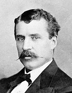
John Thomas Scharf was an American historian, author, journalist, antiquarian, politician, lawyer and Confederate States of America soldier and sailor. He is best known for his published historical works. Modern historians and researchers cite his comprehensive histories as primary source materials.
Petersville is an unincorporated community in Frederick County, Maryland, United States. Petersville is located at the junction of Maryland routes 79 and 180, 1.3 miles (2.1 km) northeast of Rosemont.
Daisy is an unincorporated community located at the northwest tip of Howard County, Maryland, United States.
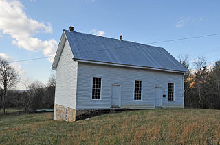
Johnsville Meetinghouse, also known as Johnsville Old German Baptist Meetinghouse, is a historic Old German Baptist Brethren meeting house located near Catawba, Roanoke County, Virginia. It was built in 1874, and is a simple, one story, one room building with five bays and a partial basement. It has a metal gable roof and features hand-planed clapboard siding and handmade window frames and glass.
Friends meeting houses are places of worship for the Religious Society of Friends, or Quakers. A "meeting" is the equivalent of a church congregation, and a "meeting house" is the equivalent of a church building.


