Frederick County is located in Maryland, United States. As of the 2020 U.S. census, the population was 271,717. The county seat is Frederick.
Ballenger Creek is an unincorporated community and census-designated place (CDP) in Frederick County, Maryland, United States. It is a part of the Frederick, Maryland urban area and is adjacent to Frederick's southern city limits. The CDP had a 2010 census population of 18,274.

Burkittsville is a historic village in Frederick County, Maryland, United States. The village lies in the southern Middletown Valley along the eastern base of South Mountain.
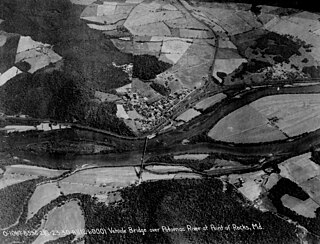
Point of Rocks is an unincorporated community and census-designated place (CDP) in Frederick County, Maryland. As of the 2010 census, it had a population of 1,466.
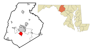
Bartonsville is an unincorporated community and census-designated place (CDP) in Frederick County, in the U.S. state of Maryland. As of the 2020 census it had a population of 2,753. Prior to 2010, the area was part of the Linganore-Bartonsville CDP.

The Monocacy River is a free-flowing left tributary to the Potomac River, which empties into the Atlantic Ocean via the Chesapeake Bay. The river is 58.5 miles (94.1 km) long, with a drainage area of about 970 square miles (2,500 km2). It is the largest Maryland tributary to the Potomac.

Adamstown is an unincorporated community and census-designated place (CDP) in Frederick County, Maryland, United States. It is named for Adam Kohlenberg, a station agent and first town merchant who owned much of present-day Adamstown. As of the 2010 census, the Adamstown CDP had a population of 2,372.

Maryland Route 355 (MD 355) is a 36.75-mile (59.14 km) north–south road in western central Maryland in the United States. The southern terminus of the route is in Bethesda in Montgomery County, where Wisconsin Avenue meets the county's border with Washington, D.C. The northern terminus is just north of a bridge over Interstate 70 (I-70)/U.S. Route 40 (US 40) in the city of Frederick in Frederick County, where the road continues north as Market Street through Frederick towards MD 26.

Maryland Route 85 is a state highway in the U.S. state of Maryland. Known as Buckeystown Pike, the state highway runs 10.80 miles (17.38 km) from MD 28 in Tuscarora north to the Frederick city limit north of Interstate 70 (I-70), where the highway continues north as East Street. MD 85 connects Tuscarora and Buckeystown in southern Frederick County with the county seat of Frederick. The state highway also links the suburban area between Buckeystown and Frederick with I-70 and I-270. MD 85 is the old alignment of U.S. Route 15, which was originally constructed between Tuscarora and Frederick in the late 1910s and early 1920s. MD 85 was assigned to the highway in 1970 when US 15 was moved to a new highway heading north from its Potomac River crossing at Point of Rocks. The state highway was extended north to the city of Frederick as part of a project to overhaul MD 355's interchange with I-70 in the first decade of the 21st century.

U.S. Route 15 (US 15) is a part of the United States Numbered Highway System that runs from Walterboro, South Carolina, north to Painted Post, New York. In Maryland, the highway runs 37.85 miles (60.91 km) from the Virginia state line at the Potomac River in Point of Rocks north to the Pennsylvania state line near Emmitsburg. Known for most of its length as Catoctin Mountain Highway, US 15 is the primary north–south highway of Frederick County. The highway connects the county seat of Frederick with Point of Rocks, Leesburg, Virginia, and Charles Town, West Virginia, to the south and with Thurmont, Emmitsburg, and Gettysburg, Pennsylvania, to the north. US 15 is a four-lane divided highway throughout the state except for the portion between the Point of Rocks Bridge and the highway's junction with US 340 near Jefferson. The highway is a freeway along its concurrency with US 340 and through Frederick, where the highway meets US 40 and Interstate 70 (I-70). US 15 has a business route through Emmitsburg.
Ballenger Creek is a 10.7-mile-long (17.2 km) tributary of the Monocacy River in Frederick County, Maryland. The headwaters of the creek are located on the east slope of Catoctin Mountain, about 3 miles (5 km) west of the city of Frederick. The stream runs roughly southeast to the Monocacy National Battlefield and the confluence with the Monocacy River, which drains to the Potomac River. The watershed area of the creek is 21.8 square miles (56 km2).
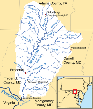
Linganore Creek is a 13.5-mile-long (21.7 km) tributary of the Monocacy River in Frederick County, Maryland. The stream is formed from the confluence of the north and south forks of the Linganore, about 10 miles (16 km) east-northeast of the city of Frederick. The creek runs roughly southwest to the Monocacy River, which drains to the Potomac River. The watershed area of the creek is 83.1 square miles (215 km2). High water in the creek can result in flooding of Gas House Pike, an east–west road running between Monocacy Boulevard and Green Valley Road.

The Buckeystown Historic District includes the majority of the small town of Buckeystown, Maryland, an unincorporated community located in Frederick County, Maryland, USA. It is named for George Buckey, a tanner, and his brother, John Buckey, a blacksmith and tavern owner. Buckeystown is on the U.S National Register of Historic Places and the Maryland Civil War Trail due to its rich history and beautiful examples of Queen Anne and Victorian style houses, along with a small commercial center. Each historic home has a plaque indicating the year built, the earliest being circa 1780. There are also several historical information plaques installed along the main street.

Johnsville is an unincorporated community in Frederick County, Maryland, United States. It is located approximately halfway between Libertytown and Union Bridge along Maryland Route 75. The Kitterman-Buckey Farm was listed on the National Register of Historic Places in 2005.
Ballenger is a surname. Notable people with the surname include:
Petersville is an unincorporated community in Frederick County, Maryland, United States. Petersville is located at the junction of Maryland routes 79 and 180, 1.3 miles (2.1 km) northeast of Rosemont.

Broad Run is an unincorporated community in Frederick County, Maryland, United States. Broad Run is located on Maryland Route 383, 4.5 miles (7.2 km) southeast of Middletown.

Monocacy was a village in Frederick County, Maryland that was located along an old Indian trail known as the Monocacy Trail that ran parallel to the Monocacy River. The trail was known as the Great Wagon Road by colonial travelers; it went to Philadelphia, Pennsylvania and later was renamed Monocacy Road. Early surviving historical records indicate that Monocacy was the oldest settlement in Western Maryland. The town is believed to have been located near present-day Creagerstown, but never has been precisely located after its complete abandonment in the early 19th century. There are signs of the town's existence going back as far as 1730.
Spring Ridge is census-designated place (CDP) and suburban housing community in Frederick County, in the U.S. state of Maryland, just outside the city of Frederick. As of the 2020 census it had a population of 6,005. Before 2010, it was part of the Linganore-Bartonsville, Maryland census-designated place, which was split into three for the 2010 census.
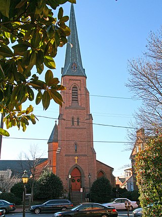
All Saints Church, or All Saints Episcopal Church, founded in 1742, is a historic Episcopal church now located at 106 West Church Street in the Historic District of Frederick, Maryland. It is the seat of All Saints Parish, Diocese of Maryland, which covers most of Frederick County, Maryland and once covered most of Western Maryland.


