
Mono County is a county located in the east central portion of the U.S. state of California. As of the 2020 census, the population was 13,195, making it the fourth-least populous county in California. The county seat is Bridgeport. The county is located east of the Sierra Nevada between Yosemite National Park and Nevada. The only incorporated town in the county is Mammoth Lakes, which is located at the foot of Mammoth Mountain. Other locations, such as June Lake, are also famous as skiing and fishing resorts. Located in the middle of the county is Mono Lake, a vital habitat for millions of migratory and nesting birds. The lake is located in a wild natural setting, with pinnacles of tufa arising out of the salty and alkaline lake. Also located in Mono County is Bodie, the official state gold rush ghost town, which is now a California State Historic Park.

Henry County is a county located in the U.S. state of Illinois. The 2020 United States Census, listed its population at 49,284. Its county seat is Cambridge.

Spalding County is a county located in the west central portion of the U.S. state of Georgia. As of the 2020 census, the population was 67,306. The county seat is Griffin. The county was created December 20, 1851 and named for former United States representative and senator Thomas Spalding.

Fortuna is a city on the northeast shore of the Eel River, approximately 9 miles (14 km) from where it enters the Pacific Ocean, and is on U.S. Route 101 in west-central Humboldt County, California, United States. The population was 12,516 at the 2020 census, up from 11,926 at the 2000 census.

Sunny Isles Beach is a city located on a barrier island in northeast Miami-Dade County, Florida, United States. The city is bounded by the Atlantic Ocean on the east and the Intracoastal Waterway on the west. As of the 2020 census, it had a population of 22,342.

Joliet is a city in Will and Kendall counties in the U.S. state of Illinois, 35 miles (56 km) southwest of Chicago. It is the county seat of Will County. At the 2020 census, the city was the third-largest in Illinois, with a population of 150,362.

Clearfield is a borough and the county seat of Clearfield County, Pennsylvania, United States. As of the 2020 census the population was 5,962 people, making it the second most populous community in Clearfield County, behind DuBois. The borough is part of the DuBois, PA Micropolitan Statistical Area, as well as the larger State College-DuBois, PA Combined Statistical Area. The settled area surrounding the borough consists of the nearby census-designated places of Hyde and Plymptonville, which combined with Clearfield have a population of approximately 8,237 people.

Greenville is a town in Hillsborough County, New Hampshire, United States. The population was 1,974 at the 2020 census, down from 2,105 at the 2010 census. It is located at the junctions of New Hampshire routes 31, 45, and 123.
Gaviota State Park is a state park of California, United States. It is located in southern Santa Barbara County, California, about 33 miles (53 km) west of the city of Santa Barbara. One of three state parks along the Gaviota Coast, it extends from the Pacific coast to the crest of the Santa Ynez Mountains, and is adjacent to Los Padres National Forest. The 2,787-acre (1,128 ha) park was established in 1953.

State Road 856 (SR 856), also known as the William Lehman Causeway, is a 1.704-mile-long (2.742 km) causeway connecting Biscayne Boulevard in Aventura and Collins Avenue (SR A1A) in Sunny Isles Beach, Florida.
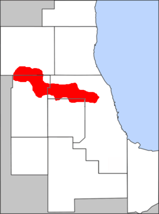
The Golden Corridor is the area around the Jane Addams Memorial Tollway, formerly known as the Northwest Tollway, in the Chicago metropolitan area. Its name refers to the "gold" mine of economic profit for communities in the area. Several Fortune 500 company headquarters, office parks, industrial parks, exhibition and entertainment centers, medical facilities, hotels, shopping centers, and restaurants are in the Golden Corridor. With the exception of the O'Hare area of Chicago, all the communities in this region are part of a larger region known as the "Northwest Suburbs".

Coyote is an unincorporated community in a narrowing of Santa Clara Valley astride Coyote Creek, between San Jose and Morgan Hill's Madrone district, in Santa Clara County, California. Part of Coyote is inside the city limits of San Jose. Its ZIP Code is 95013; there is a small U.S. Post Office. It is inside telephone area codes 408 and 669.

Refton is an unincorporated community and census-designated place (CDP) in Strasburg Township, Lancaster County, Pennsylvania, United States, with a ZIP code of 17560. The community is located along U.S. Route 222. As of the 2010 census, the population was 298.
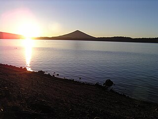
Crescent Lake is a natural lake on the eastern side of the Cascade Range in the northwest corner of Klamath County, Oregon, United States. The unincorporated community of Crescent Lake Junction on Oregon Route 58 and Crescent Lake State Airport are located 2.5 miles (4.0 km) northeast of the lake. The lake was named for its shape by Byron J. Pengra and William Holman Odell in July 1865.

Santa Rosa Beach is an unincorporated community in Walton County, Florida, United States. It is part of the Fort Walton Beach-Crestview-Destin, Florida Metropolitan Statistical Area.

Peshastin is a small unincorporated community in Chelan County, Washington, United States. The community's roots are found in the "Peshastin Ditch" dug by pioneers beginning in 1889. This ditch was an important part of the overall irrigation system in the area, delivering water to the orchards on the slopes above Cashmere. The town was first platted in the early 1890s by two brothers, J. Q. Gilbert and A. C. Gilbert. It is also noted on an 1895 map of the area, indicating it was in existence by then.
Reliance is an unincorporated community located on the border of the U.S. states of Maryland and Delaware. The Maryland side of the community has portions in Caroline and Dorchester counties, while the Delaware side is located within Sussex County. Reliance is along Delaware Route 20 and Maryland Route 392 at the junction with Maryland Route 577, west of Seaford. It was previously known as Johnson's Crossroads.
Sunny Side is an unincorporated community in Buckingham and Cumberland counties, in the U.S. state of Virginia. Sunny Side was a stop on the Farmville and Powhatan Railroad from 1884 to 1905 and then on the Tidewater and Western Railroad from 1905 to 1917. It is on the new Virginia State Route 13 between Powhatan, Virginia and Cumberland, Virginia from 1918 to today.
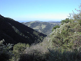
Sunny Slopes is an unincorporated community and census-designated place (CDP) in Mono County, California, United States. It sits at an elevation of 7,198 feet (2,194 m). As of the 2020 census, the population was 139, down from 182 in 2010.
The Pennsylvania State Game Lands Number 261 are Pennsylvania State Game Lands in Bedford County in Pennsylvania in the United States providing hunting, bird watching, and other activities.


