Myersville, Maryland | |
---|---|
Town of Myersville | |
Coordinates: 39°30′18″N77°34′05″W / 39.50500°N 77.56806°W | |
Country | United States of America |
State | Maryland |
County | Frederick |
Incorporated | 1904 [1] |
Area | |
• Total | 1.12 sq mi (2.90 km2) |
• Land | 1.12 sq mi (2.90 km2) |
• Water | 0.00 sq mi (0.00 km2) |
Elevation | 620 ft (190 m) |
Population (2020) | |
• Total | 1,748 |
• Density | 1,559.32/sq mi (602.24/km2) |
Time zone | UTC-5 (Eastern (EST)) |
• Summer (DST) | UTC-4 (EDT) |
ZIP code | 21773 |
Area code(s) | 301, 240 |
FIPS code | 24-54875 |
GNIS feature ID | 2391320 [3] |
Website | myersville |
Myersville is a town in Frederick County, Maryland, United States. The population was 1,626 at the 2010 United States Census.
The town was incorporated in 1904. [1]
On January 4, 1919, a large fire destroyed many shops and buildings in the center of town.
The Peter of P. Grossnickel Farm was listed on the National Register of Historic Places in 1998. [4]
In October 2002, the Washington, D.C. metropolitan area snipers John Allen Muhammad and Lee Boyd Malvo who terrorized the region were apprehended at a rest stop along westbound I-70 in Myersville. The two were discovered when a truck driver recognized their car from police reports.
According to the United States Census Bureau, the town has a total area of 1.02 square miles (2.64 km2), all land. [5] The Myersville area is the source of Catoctin Creek, which roughly flows in a "C" loop pattern (northside to eastside to southside) just outside the city limits.
The main method of transport to and from Myersville is by road. The main highway that serves the town is Interstate 70, which heads eastward from Myersville to Baltimore and westward to Pittsburgh. Access to Myersville is provided via an interchange with Maryland Route 17, the other highway directly serving the town, which serves western Frederick County on a north–south alignment. U.S. Route 40 passes just to the northeast of the town limits and provides an alternative to I-70 for east–west travelers.
Census | Pop. | Note | %± |
---|---|---|---|
1870 | 139 | — | |
1880 | 138 | −0.7% | |
1910 | 240 | — | |
1920 | 239 | −0.4% | |
1930 | 262 | 9.6% | |
1940 | 310 | 18.3% | |
1950 | 250 | −19.4% | |
1960 | 355 | 42.0% | |
1970 | 450 | 26.8% | |
1980 | 432 | −4.0% | |
1990 | 464 | 7.4% | |
2000 | 1,382 | 197.8% | |
2010 | 1,626 | 17.7% | |
2020 | 1,748 | 7.5% | |
U.S. Decennial Census [6] |
As of the census [7] of 2010, there were 1,626 people, 531 households, and 437 families living in the town. The population density was 1,594.1 inhabitants per square mile (615.5/km2). There were 553 housing units at an average density of 542.2 per square mile (209.3/km2). The racial makeup of the town was 95.1% White, 2.2% African American, 0.2% Native American, 1.3% Asian, 0.2% from other races, and 1.0% from two or more races. Hispanic or Latino of any race were 3.5% of the population.
There were 531 households, of which 49.5% had children under the age of 18 living with them, 70.8% were married couples living together, 8.7% had a female householder with no husband present, 2.8% had a male householder with no wife present, and 17.7% were non-families. 13.2% of all households were made up of individuals, and 6.7% had someone living alone who was 65 years of age or older. The average household size was 3.06 and the average family size was 3.41.
The median age in the town was 38.1 years. 30.8% of residents were under the age of 18; 8.5% were between the ages of 18 and 24; 23.7% were from 25 to 44; 30.1% were from 45 to 64; and 6.9% were 65 years of age or older. The gender makeup of the town was 50.2% male and 49.8% female.
At the 2000 census, [8] there were 1,382 people, 439 households, and 378 families living in the town. The population density was 1,704.9 inhabitants per square mile (658.3/km2). There were 450 housing units at an average density of 555.2 per square mile (214.4/km2). The racial makeup of the town was 98.48% White, 0.65% African American, 0.07% Native American, 0.29% Asian, 0.43% from other races, and 0.07% from two or more races. Hispanic or Latino of any race were 0.94% of the population.
There were 439 households, of which 57.9% had children under the age of 18 living with them, 76.1% were married couples living together, 9.1% had a female householder with no husband present, and 13.7% were non-families. 11.2% of all households were made up of individuals, and 4.3% had someone living alone who was 65 years of age or older. The average household size was 3.15 and the average family size was 3.44.
The age distribution was 38.7% under the age of 18, 3.0% from 18 to 24, 35.2% from 25 to 44, 16.3% from 45 to 64, and 6.8% who were 65 years of age or older. The median age was 33 years. For every 100 females, there were 100.9 males. For every 100 females age 18 and over, there were 92.9 males.
The median household income was $72,639, and the median family income was $75,768. Males had a median income of $53,125 versus $38,295 for females. The per capita income for the town was $24,207. About 0.5% of families and 0.7% of the population were below the poverty line, including none of those under age 18 and 3.8% of those age 65 or over.
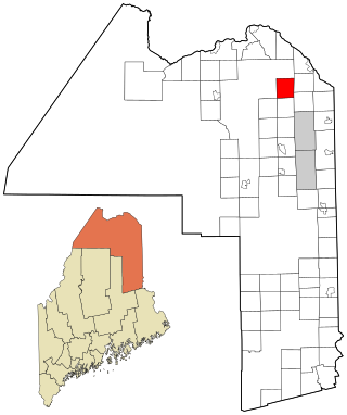
Stockholm is a town in Aroostook County, Maine, United States. The population was 250 at the 2020 census.
Stacyville is a town in Penobscot County, Maine, United States, in the foothills of Mount Katahdin. The population was 380 at the 2020 census.
Westernport is a town in Allegany County, Maryland, United States, along the Georges Creek Valley. It is part of the Cumberland, MD-WV Metropolitan Statistical Area. The population was 1,888 at the 2010 census.
Hurlock is a town in Dorchester County, Maryland, United States. The population was 2,092 at the 2010 census.
Middletown is a town in Frederick County, Maryland, United States. The population was 4,136 as of the 2010 census. Located in the Middletown Valley that stretches between the Catoctin Mountains on the east and South Mountain on the west, the town reportedly gained its name from its location midway between those ranges.
Rosemont is a village in Frederick County, Maryland, United States. The population was 272 at the 2020 census. Maryland state routes 79 and 871 pass through Rosemont.
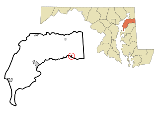
Friendsville is a town in Garrett County, Maryland, United States. The population was 438 at the 2020 census.
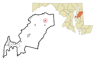
Kitzmiller is a town in Garrett County, Maryland, United States. The population was 321 at the 2010 census.
Sudlersville is a town in the far northeastern corner of Queen Anne's County, Maryland, United States. The ZIP code is 21668 and the area code is 410. The population was 497 at the 2010 census. It is perhaps best known as the hometown of Baseball Hall Of Fame slugger Jimmie Foxx. Other famous residents include astronomer and mathematician Simon Newcomb.
Clear Spring is a town in Washington County, Maryland, United States. The population was 358 at the 2010 census.
St. James is a census-designated place (CDP) in Washington County, Maryland, United States. The population was 1,657 at the 2000 census. It is also the home of St. James School, Hagerstown, a small, Episcopalian, boarding school. St. James was formerly named "Lydia."
Pittsville is a town in Wicomico County, Maryland, United States. The population was 1,417 at the 2010 census. It is included in the Salisbury, Maryland-Delaware Metropolitan Statistical Area.
Sharptown is a town in Wicomico County, Maryland, United States. The population was 651 at the 2010 census. It is included in the Salisbury, Maryland-Delaware Metropolitan Statistical Area.
Willards is a town in Wicomico County, Maryland, United States. The population was 958 at the 2010 census. It is included in the Salisbury, Maryland-Delaware Metropolitan Statistical Area.
Brookville is a small city in northwestern Montgomery County, Ohio, United States. It is a suburb of Dayton. The population was 5,989 at the 2020 census.
Mabscott is a town in Raleigh County, West Virginia, United States. The population was 1,333 at the 2020 census. The town's name is a contraction of the name Mabel Scott, wife of local coal operator Cyrus H. Scott.
Bern is a town in Marathon County, Wisconsin, United States. It is part of the Wausau, Wisconsin Metropolitan Statistical Area. The population was 591 at the 2010 census. The unincorporated community of Gad is located partially in the town.
Templeville is a town in Caroline and Queen Anne's counties, Maryland, United States. Templeville is located near the Maryland-Delaware line. The population was 138 at the 2010 census. It was known as Bullock Town until the name was changed in 1847. The name Templeville derives from the Temple family, whose most famous member was Governor William Temple of Delaware.
Millington is a town in Kent and Queen Anne's counties in the U.S. state of Maryland. The population was 642 at the 2010 census. Millington is the head of navigation for the Chester River.
Chevy Chase —formally, the Town of Chevy Chase—is an incorporated town in Montgomery County, Maryland, United States. The population was 2,904 at the 2020 census.