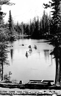
Scouting in the U.S. state of Oregon includes the Boy Scouts of America (BSA) and Girl Scouts (GSUSA) youth organizations, as well as newer organizations like the Baden-Powell Service Association.

Yachats is a small coastal city in the southernmost area of Lincoln County, Oregon, United States. According to Oregon Geographic Names, the name comes from the Siletz language and means "dark water at the foot of the mountain". There is a range of differing etymologies, however. William Bright says the name comes from the Alsea placename yáx̣ayky. At the 2010 census, the city's population was 690. In 2007, Budget Travel magazine named Yachats one of the "Ten Coolest Small Towns of the U.S.A.", and Yachats was chosen among the top 10 U.S. up-and-coming vacation destinations by Virtualtourist. In 2015, Arthur Frommer, founder of Frommer's Travel Guides, listed Yachats number eight among his ten favorite vacation destinations in the world.

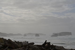
The Oregon Coast is a coastal region of the U.S. state of Oregon. It is bordered by the Pacific Ocean to its west and the Oregon Coast Range to the east, and stretches approximately 362 miles (583 km) from the California state border in the south to the Columbia River in the north. The region is not a specific geological, environmental, or political entity, and includes the Columbia River Estuary.

The Yaquina River is a stream, 59 miles (95 km) long, on the Pacific coast of the U.S. state of Oregon. It drains an area of the Central Oregon Coast Range west of the Willamette Valley near Newport.

The Oregon Coast Trail (OCT) is a long-distance hiking route along the Pacific coast of the U.S. state of Oregon in the United States. It follows the coast of Oregon from the mouth of the Columbia River to the California border south of Brookings.

U.S. Route 101 (US 101), is a major north–south U.S. Highway in Oregon that runs through the state along the coastline near the Pacific Ocean. It runs from the California border, south of Brookings, to the Washington state line on the Columbia River, between Astoria, Oregon, and Megler, Washington.

Oswald West State Park is part of the state park system of the U.S. state of Oregon. It is located about 10 miles (16 km) south of the city of Cannon Beach, adjacent to Arch Cape, on the Pacific Ocean. The park covers 2,448 acres (9.91 km2), with many miles of hiking trails both inside the park grounds and linking to other parks and landmarks beyond.
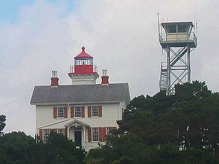
The Yaquina Bay Light is a lighthouse that was built in 1871, soon after the founding of the city of Newport, Oregon, in the United States. It is located on the north side of Yaquina Bay. In 1871–1874, it was the busiest and most populated of the many coastal ports between Washington and California.

The Tryon Creek State Natural Area is a state park located primarily in Portland, in the U.S. state of Oregon. It is the only Oregon state park within a major metropolitan area. The 645-acre (261 ha) park lies between Boones Ferry Road and Terwilliger Boulevard in southwest Portland in Multnomah County and northern Lake Oswego in Clackamas County and is bisected from north to south by Tryon Creek. To the north, the park abuts the Lewis & Clark Law School campus.

Chandler State Wayside is a state park in south-central Oregon in the United States. It is named in honor of Solomon and Hattie Chandler, who donated the land for the park. The park covers 85 acres (34 ha) of pine forest along a creek. The park provides restrooms and other basic facilities to accommodate the traveling public. Chandler State Wayside is administered by the Oregon Parks and Recreation Department.

Seal Rock is an unincorporated coastal community in Lincoln County, Oregon, United States, between Newport and Waldport on U.S. Route 101.
Fanno Creek is a 15-mile (24 km) tributary of the Tualatin River in the U.S. state of Oregon. Part of the drainage basin of the Columbia River, its watershed covers about 32 square miles (83 km2) in Multnomah, Washington, and Clackamas counties, including about 7 square miles (18 km2) within the Portland city limits.

Samuel H. Boardman State Scenic Corridor is a linear state park in southwestern Oregon, in the United States. It is 12 miles (19 km) long and thickly forested along steep and rugged coastline with a few small sand beaches. It is named in honor of Samuel H. Boardman, the first Oregon Parks superintendent.

Devils Punch Bowl State Natural Area is a state day use park on the central Oregon Coast in the United States. It is centered on a large bowl naturally carved in a rock headland which is partially open to the Pacific Ocean. Waves enter the bowl and often violently churn, swirl, and foam. Outside the bowl, ocean conditions are attractive to surfers near a large offshore rock pinnacle named Gull Rock, located about 1⁄2 mile (800 m) west-northwest of Devils Punch Bowl, which funnels and concentrates waves easily seen from the park. There are at least seventeen large rocks, part of Oregon Islands National Wildlife Refuge, which provide interesting wave viewing, and attract and provide a home for wildlife.
Bandon State Natural Area is a state park in the U.S. state of Oregon. It is administered by the Oregon Parks and Recreation Department. The 879-acre (356 ha) park lies west of U.S. Route 101, off Beach Loop Drive, about 5 miles (8 km) south of Bandon. The Oregon Coast Trail passes through the park.
Arizona Beach State Recreation Site is a 68-acre (28 ha) Oregon state park in Curry County, Oregon, in the United States. The beach is at an average elevation of 7 feet (2 m). Public recreational facilities at Arizona Beach State Recreation Site include a parking lot for beach access, observation areas for viewing marine mammals and birds and tables for picnicking. The park is open year-round.
The Little North Santiam River is a 27-mile (43 km) tributary of the North Santiam River in western Oregon in the United States. It drains 113 square miles (290 km2) of the Cascade Range on the eastern side of the Willamette Valley east of Salem.

Nye Beach is a central district in Newport in the U.S. state of Oregon. The Nye Beach historic overlay district is bounded on the north and south sides by Northwest Twelfth Street and Southwest Second Street respectively; on the east side by Hurbert Street and on the west side by the Pacific Ocean. Situated on a sea cliff, the district has been a popular vacation spot since the late 19th century. Cultural and literary groups such as Oregon Coast Council for the Arts, Yaquina Art Association, and Writers on the Edge are based in Nye Beach, as are Newport's Performing Arts and Visual Arts Centers. The beach attracts tide-pool enthusiasts and beachcombers as well as surfers, sail-boarders, crabbers, clam diggers, kite flyers, photographers, and artists and has also been the site of marine and geological research projects.

Redmond–Bend Juniper State Scenic Corridor is a collection of ten unimproved land parcels administered for the Oregon Parks and Recreation Department. The parcels are located along U.S. Route 97 between Bend and Redmond, Oregon, United States. It is named for the large western juniper trees found on the parcels. The scenic corridor is completely undeveloped with no trails or park facilities of any kind.

Floras Lake is a natural 236-acre (96 ha) body of water on the southern Oregon Coast of the United States. Fed by four small tributaries from a basin of about 10 square miles (26 km2) in Curry County, it lies about 10 miles (16 km) north of Port Orford and 2 miles (3 km) west of U.S. Route 101. It was probably named for Fred Flora, a 19th-century settler and miner who lived nearby.


