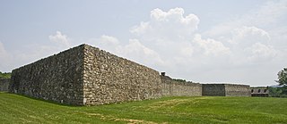
Locust Point is a peninsular neighborhood in Baltimore, Maryland. Located in South Baltimore, the neighborhood is entirely surrounded by the Locust Point Industrial Area; the traditional boundaries are Lawrence street to the west and the Patapsco River to the north, south, and east. It once served as a center of Baltimore's Polish-American, Irish-American and Italian-American communities; in more recent years Locust Point has seen gradual gentrification with the rehabilitation of Tide Point and Silo Point. The neighborhood is also noted as being the home of Fort McHenry and the western end of its namesake tunnel that carries eight lanes of Interstate 95 under the river.
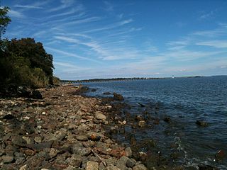
Point Lookout State Park is a public recreation area and historic preserve occupying Point Lookout, the southernmost tip of a peninsula formed by the confluence of Chesapeake Bay and the Potomac River in St. Mary's County, Maryland. The state park preserves the site of an American Civil War prisoner of war camp and the Point Lookout Light, which was built in 1830. It is the southernmost spot on Maryland's western shore, the coastal region on the western side of the Chesapeake Bay.
Fort Frederick State Park is a public recreation and historic preservation area on the Potomac River surrounding the restored Fort Frederick, a fortification active in the French and Indian War (1754–1763) and the American Revolutionary War (1775-1783). The state park lies south of the town of Big Pool, Maryland. The Chesapeake and Ohio Canal runs through the park grounds. The site was designated a National Historic Landmark in 1973.

Ebey's Landing National Historical Reserve is a unit of the National Park Service on Whidbey Island in the Puget Sound, near Coupeville in Island County, Washington, United States.
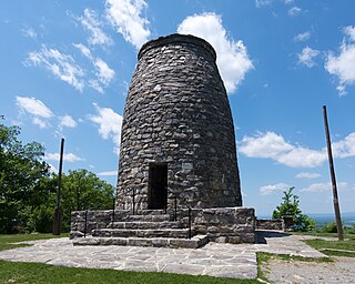
Washington Monument State Park is a public recreation area located approximately one mile (1.6 km) southeast of Boonsboro, Maryland. The park preserves the Washington Monument, a 40-foot-tall (12 m) tower honoring George Washington, the first President of the United States. The monument sits along the Appalachian Trail near the summit of South Mountain's Monument Knob. It was added to the National Register of Historic Places in 1972. The park is managed by the Maryland Department of Natural Resources.

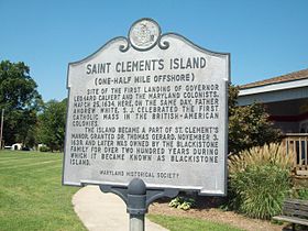
Maryland Day is a legal holiday in the U.S. state of Maryland. It is observed on the anniversary of the March 25, 1634, landing of the first European settlers in the Province of Maryland, the third English colony to be settled in British North America. On this day settlers from The Ark and The Dove first set foot onto Maryland soil, at St. Clement's Island in the Potomac River. The settlers were about 150 in number, departed from Gravesend on the Thames River downstream from London. Three Jesuit priests were collected from Cowes on the Isle of Wight in England where they avoided having to give the oath of allegiance and supremacy to the King. The colony's grant was renewed to Cecil Calvert, 2nd Baron Baltimore, (1605-1675), two years prior by Charles I of England, after first being given to his father Sir George Calvert, 1st Baron Baltimore, (1574-1632), along with the title of "Lord Baltimore", and a first grant of the Province of Avalon, in the Newfoundland Colony,, who had served the King in many official and personal capacities as Secretary of State, 1619-1625. In thanksgiving for the safe landing, Jesuit Father Andrew White celebrated the Mass for the colonists led by the younger brother of Lord Baltimore, Leonard Calvert, (1606-1647), who served as the first governor, and perhaps for the first time ever in this part of the world on the first landing at Blackistone Island, later known as St. Clement's Island off the northern shore of the Potomac River, which was the new border between the new colony and the earlier English settlements in Virginia) and erected a large cross. The landing coincided with the Feast of the Annunciation, a holy day honoring Mary, and the start of the new year in England's legal calendar. Maryland Day on 25 March celebrates the 1634 landing at St Clements. Later the colonists and their two ships sailed further back down river to the southeast to settle a capital at St. Mary's City near the point where the Potomac flows into the Chesapeake Bay.

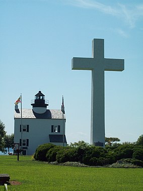
The Blackistone Island Light was a lighthouse located on what is now St. Clement's Island on the Potomac River in Maryland. It is best known as the target of a Confederate raid in the Civil War. Completed in 1851, the structure was destroyed by fire in 1956 and its shell was razed; a replica was completed in 2008.
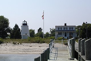
The Piney Point Lighthouse was built in 1836 located at Piney Point on the Potomac River in Maryland just up the river from the mouth of the Chesapeake Bay. The Coast Guard decommissioned it in 1964 and it has since become a museum. It is known as the Lighthouse of Presidents because several early US Presidents visited or stayed on the grounds.

Sandy Point State Park is a public recreation area on Chesapeake Bay, located at the western end of the Chesapeake Bay Bridge in Anne Arundel County, Maryland. The state park is known for the popularity of its swimming beach, with annual attendance exceeding one million visitors. The park grounds include the Sandy Point Farmhouse, which is listed on the National Register of Historic Places. The historic Sandy Point Shoal Lighthouse stands in about five feet of water some 1,000 yards (910 m) east of the park's beach.
North Point State Park is a public recreation area located on Chesapeake Bay in Edgemere, Baltimore County, Maryland. The state park includes the site of the former Bay Shore Park, which was one of the state's premiere amusement parks during the first half of the 20th century. The park features restored remnants of the old amusement park as well as facilities for swimming, picnicking, bicycling, and hiking. Black Marsh, a 667-acre (270 ha) state wildlands area, makes up half the park's area. The park is administered by the Maryland Department of Natural Resources.

The Casselman Bridge is a historic transportation structure on the Casselman River, located immediately east of Grantsville in Garrett County, Maryland. The bridge was built in 1813-1814 as part of the National Road. Historic markers posted at each end read:
Erected 1813 by David Shriver, Jr.,
Sup't of the "Cumberland Road". This 80 foot span
was the largest stone arch in America
at the time. It was continuously
used from 1813 to 1933.

This is a list of the National Register of Historic Places listings in Ashland County, Wisconsin. It is intended to provide a comprehensive listing of entries in the National Register of Historic Places that are located in Ashland County, Wisconsin. The locations of National Register properties for which the latitude and longitude coordinates are included below may be seen in a map.

Chapel Point State Park is an undeveloped public recreation area located on the Port Tobacco River, a tributary of the Potomac, in Charles County, Maryland. The state park offers fishing and hunting. Adjacent to the park, St. Ignatius Church and cemetery, the oldest continuous Roman Catholic parish in the United States, offers a scenic river view.

Greenwell State Park is a public recreation area located on the Patuxent River in St. Mary's County, Maryland. The state park features the historic Rosedale Manor House as well as the Bonds-Simms tobacco barns complex. Park activities include hiking, cycling, horseback riding, fishing, picnicking, hunting, swimming, and canoeing.
St. Mary's River State Park is a public recreation area located in St. Mary's County, Maryland. The state park consists of two sites: one encompasses 250-acre (100 ha) St. Mary's Lake ; the second covers 2,200 acres (890 ha) and is largely undeveloped. The park is managed by the Maryland Department of Natural Resources.

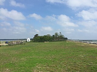
Coltons Point is an unincorporated community in what is popularly called the "Seventh District" of St. Mary's County, Maryland, United States. Here are located a small historical museum and a lighthouse. Seasonal boat service at times carries visitors the short distance to the shrinking, uninhabited St. Clement's Island, where in 1634 the first European settlers arriving in Maryland landed and celebrated the first Catholic Mass in English-speaking North America. It was listed on the National Register of Historic Places in 1972. The ZIP Code for Coltons Point is 20626.
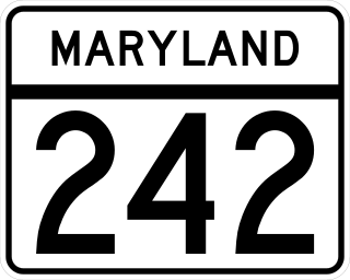
Maryland Route 242 is a state highway in the U.S. state of Maryland. Known as Colton Point Road, the state highway runs 12.80 miles (20.60 km) from Coltons Point north to MD 5 in Morganza. MD 242 connects the communities of Morganza, Clements, Bushwood, Avenue, and Coltons Point in western St. Mary's County. The state highway also leads to St. Clement's Island State Park, the site of Maryland's First Landing. MD 242 was constructed in the early 1920s.
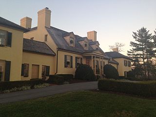
The Belmont Estate, now Belmont Manor and Historic Park, is a former plantation located at Elkridge, Howard County, Maryland, United States. Founded in the 1730s and known in the Colonial period as "Moore's Morning Choice", it was one of the earliest forced-labor farms in Howard County, Maryland. Its 1738 plantation house is one of the finest examples of Colonial Georgian architectural style in Maryland.

Newtowne Neck State Park is a public recreation area located four miles (6.4 km) southwest of Leonardtown in St. Mary's County, Maryland. The state park sits on a peninsula that is surrounded by Breton Bay, St. Clements Bay, and the Potomac River. It is managed by the Maryland Department of Natural Resources.
Elkridge Landing was a Patapsco River seaport in Maryland, and is now part of Elkridge, Maryland. The historic Elkridge Furnace Inn site resides within the Patapsco Valley State Park.