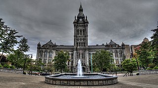
Erie County is a county along the shore of Lake Erie in western New York State. As of the 2020 census, the population was 954,236. The county seat is Buffalo, which makes up about 28% of the county's population. Both the county and Lake Erie were named for the regional Iroquoian language-speaking Erie tribe of Native Americans, who lived in the area before 1654. They were later pushed out by the more powerful Iroquoian nations tribes.

Ellicott is a town in Chautauqua County, New York, United States. The population was 8,771 at the 2020 census. The town is named after Joseph Ellicott, an agent of the Holland Land Company.

Amherst is a town in Erie County, New York, United States. It is a suburb of Buffalo. As of 2020, the town had a total population of 129,595. This represents an increase from 122,366 as reported in the 2010 census.

Clarence is a town and affluent suburb located in the northeastern part of Erie County, New York, United States, northeast of Buffalo. The population was 32,950 according to the 2020 census estimate. This represents an increase of 7.4% from the 2010 census figure. The Clarence census-designated place occupies the southeast part of the town and roughly corresponds to a postal district with ZIP code 14031 and 14221 in the western side which it shares with nearby Williamsville. The town is named in honor of Prince William, Duke of Clarence and St Andrews (1765–1837), the third son of King George III and later king himself, as William IV.

Elma is a town in Erie County, New York, United States. The population was 11,721 at the 2020 census. The town is named after the American elm tree.

Pembroke is a town in Genesee County, Western New York, United States. The population was 4,292 at the 2010 census. The town is named for a town in west Wales. Pembroke lies on the west border of Genesee County, west of Batavia.

Alden is a town in Erie County, New York, United States. The population was 10,865 at the 2010 census. The town is derived from a family name known to early settlers.

Lancaster is a village in Erie County, New York, United States. As of the 2010 census, the village population was 10,352. It is part of the Buffalo–Niagara Falls Metropolitan Statistical Area.

Lancaster is a town in Erie County, New York, United States, centered 14 miles east of downtown Buffalo. Lancaster is an outer ring suburb of Buffalo. As of the 2020 Census, the town population was 45,106.

New York State Route 5 (NY 5) is a state highway that extends for 370.80 miles (596.74 km) across the state of New York in the United States. It begins at the Pennsylvania state line in the Chautauqua County town of Ripley and passes through Buffalo, Syracuse, Utica, Schenectady, and several other smaller cities and communities on its way to downtown Albany in Albany County, where it terminates at U.S. Route 9 (US 9), here routed along the service roads for Interstate 787 (I-787). Prior to the construction of the New York State Thruway, it was one of two main east–west highways traversing upstate New York, the other being US 20. West of New York, the road continues as Pennsylvania Route 5 (PA 5) to Erie.

New York State Route 33 (NY 33) is an east–west state highway in western New York in the United States. The route extends for just under 70 miles (113 km) from NY 5 in Buffalo in the west to NY 31 in Rochester in the east. It is, in fact, the only state highway that directly connects both cities, although it is rarely used today for that purpose. The westernmost 10 miles (16 km) of NY 33 in Buffalo and the neighboring town of Cheektowaga have been upgraded into the Kensington Expressway. This section of NY 33 is one of several expressways leading out of downtown and serves as a main route to the Buffalo Niagara International Airport.

Ellicott Creek is a stream in Western New York, United States. It is a tributary of Tonawanda Creek, which in turn flows into the Niagara River.

New York State Route 78 (NY 78) is a 73.49-mile-long (118.27 km) state highway in western New York in the United States. While it is signed north–south, the southern portion runs in an east–west direction across Wyoming and Erie counties, from its beginning at a junction with NY 19 north of the village of Gainesville to the village of East Aurora. The part of the route north of East Aurora follows a generally north–south alignment to an intersection with NY 18 in the Niagara County town of Newfane, just south of the Lake Ontario shoreline. The route is most closely identified in the region with Transit Road, a major north–south trunk road through the center of Erie and Niagara counties; however, NY 78 does not follow Transit Road for its entire length, nor does Transit Road comprise more than half its length. The highway joins Transit Road north of East Aurora and stays with the road until nearly its end in the city of Lockport.

New York State Route 277 (NY 277) is a state highway in New York in the United States. This highway is also called Union Road, along with other names. NY 277 is a major north–south road east of Buffalo, New York, through the middle of Erie County. The section of NY 277 north of Orchard Park used to be New York State Route 18B until the portion of NY 18 south of Niagara Falls was deleted on January 1, 1962.

New York State Route 354 (NY 354) is a state highway in New York in the United States. NY 354 is one of several highways radiating eastward from its western terminus in downtown Buffalo. The east terminus of NY 354 is in the village of Attica, where it ends at NY 98 and NY 238 as West Main Street. This highway runs through the center of Erie County to the northern county line of Wyoming County.

New York State Route 98 (NY 98) is a state highway in the western part of New York in the United States. The southern terminus of the route is at an intersection with U.S. Route 219 (US 219) in the town of Great Valley in Cattaraugus County. The northern end is at an interchange with the Lake Ontario State Parkway in the town of Carlton in Orleans County, near the southern shore of Lake Ontario. In between, NY 98 serves the city of Batavia, connects to the New York State Thruway, and passes by the Attica Correctional Facility. Most of the route passes through rural, undeveloped areas; however, in southern Genesee County, it traverses more urbanized areas that lie in and around Batavia.

New York State Route 63 (NY 63) is a state highway in the western part of New York in the United States. It extends for 82.11 miles (132.14 km) in a generally southeast–northwest direction from an intersection with NY 15 and NY 21 in the village of Wayland in Steuben County to a junction with NY 18 in the town of Yates in Orleans County, 2 miles (3.2 km) south of the Lake Ontario shoreline. The route passes through the city of Batavia and enters or comes near several villages, including Dansville and Medina.

U.S. Route 20A (US 20A) is an east–west alternate route of US 20 that extends for 83.59 miles (134.53 km) across the western portion of New York in the United States. It leaves US 20 in Hamburg, a suburb of Buffalo, and rejoins it in East Bloomfield about five miles (8.0 km) west of Canandaigua, the county seat of Ontario County. The western terminus is situated just northeast of the intersection of US 20 and US 62 and west of Highmark Stadium. At its east end, US 20A also meets New York State Route 5 (NY 5) and NY 64. Most of the route is known as Big Tree Road; outside Highmark Stadium, the highway is known as the Timothy J. Russert Highway in memory of Buffalo native Tim Russert.

U.S. Route 62 is a part of the U.S. Highway System that travels from the United States–Mexico border at El Paso, Texas, to Niagara Falls, New York. In the U.S. state of New York, US 62 extends 102.77 miles (165.39 km) from the New York–Pennsylvania border south of Jamestown to an intersection with New York State Route 104 in downtown Niagara Falls, bypassing the city of Jamestown and serves the cities of Buffalo and Niagara Falls, along with several villages. It is the only north–south mainline U.S. highway in Western New York. US 62 was extended into New York c. 1932 and originally was concurrent with the state highways that had previously been designated along its routing—namely NY 18, NY 60, NY 83 and NY 241. These concurrencies were eliminated individually during the 1940s and 1960s. The last of the four concurrencies, with NY 18 from Dayton to Niagara Falls, was removed c. 1962. US 62 has one special route, US 62 Business, located in Niagara Falls. US 62 Business is a former routing of US 62 within the city and was once NY 62A.


