Lancaster (village), New York

Last updated

Lancaster
Lancaster Municipal Building (Lancaster, New York).jpg
Lancaster Village Municipal Building
Erie County New York incorporated and unincorporated areas Lancaster (village) highlighted.svg
Location in Erie County and the state of New York
Coordinates: 42°54′1″N78°40′23″W / 42.90028°N 78.67306°W / 42.90028; -78.67306
Country United States
State New York
County Erie
Town Lancaster
Incorporated1849
Named for Lancaster, Massachusetts
Government
  MayorLynne T. Ruda
  TrusteesTyler D. Sojka
Tammie Malone-Schaffer
Cynthia A. Maciejewski
John Mikoley
Area
[1]
  Total2.75 sq mi (7.13 km2)
  Land2.72 sq mi (7.04 km2)
  Water0.03 sq mi (0.09 km2)
Elevation
673 ft (205 m)
Population
 (2020)
  Total10,027
  Density3,689.11/sq mi (1,424.27/km2)
Time zone UTC-5 (Eastern (EST))
  Summer (DST) UTC-4 (EDT)
ZIP codes
14086
Area code 716
FIPS code 36-41135
Website www.lancastervillage.org

Lancaster is a village in Erie County, New York, United States. As of the 2010 census, the village population was 10,352. It is part of the Buffalo-Niagara Falls metropolitan area.

Contents

The village of Lancaster is in the west part of the town of Lancaster and is east of Buffalo.

The Lancaster Opera House is locally famous for its musicals and stage plays. The current mayor is Lynne T. Ruda. [2]

History

The Village of Lancaster was incorporated in 1849 from part of the town of Lancaster. Lancaster is the third oldest incorporated village in Erie County, behind Springville and Gowanda. The village is proud of its historic past and emphasizes preservation of its historic buildings. Lancaster was formerly known as "Cayuga Creek". Lancaster is one of approximately 30 communities in New York with historic districts.

The oldest house in the village is the Carpenter–Draper House, built in 1831. The Lancaster Presbyterian Church is the second oldest religious structure in Erie County, built in 1832.

Churches in the village include Lancaster Presbyterian Church, St. John's Lutheran, Trinity Episcopal, and Faith United Methodist. Catholic churches include St. Mary of the Assumption and Our Lady of Pompeii.

In 1894 the Lancaster Opera House was built. This building is still the main focus of the downtown Lancaster area because of its massive size and its clock tower. Lancaster Town offices are located in the building. This leads people to call the building both the Opera House and Town Hall.

The Central Avenue/Broadway area is the downtown business area in the village. The former West Main Street was at one time another major business street in the downtown area. However, today very few businesses are located on the street due to its demolition in the early 1970s. In the near future, West Main will be re-extended all the way to the intersection of Aurora, North Aurora, and St. Mary's streets, as it had before the demolition.

Four railroads (Erie RR, Lehigh Valley RR, Delaware, Lackawanna and Western RR, and New York Central RR) once traversed the village, but only two remain. The fifth railroad in the town of Lancaster, the West Shore RR, did not go through the village, but did have a station in Bowmansville, a hamlet in the northwestern part of the town. Each railroad had a station on Central Ave.

A trolley once went through the village, down Como Park Boulevard from Buffalo, to Lake Avenue, to Church Street, to East Main Street (now Broadway), to Central Avenue, and then finally to Sawyer Avenue. The trolley then continued into the connecting village of Depew, where Sawyer Avenue turned into Main Street.

Several fires have caused damage over the years to the downtown area. The Great Fire of 1894 destroyed much of the west side of Central Avenue and the Grimes-Davis Mansion, which stood at the corner of Broadway and Central Avenue. A gas station now occupies the site.

The village includes part of Como Lake Park, owned and operated by Erie County

Church Street, a street off Broadway, contains many architecturally significant homes.

Lancaster's first immigrants were Dutch. Germans came in the mid-1800s, who founded St. Mary of the Assumption Catholic Church. Italian immigrants were the last to populate the village area. They founded Our Lady of Pompeii Catholic Church.

St. John Neumann was a circuit priest in the mid-1800s around the Buffalo area. St. Mary of the Assumption Church (St. Mary's on the Hill) was one of his stops. He celebrated mass there once a month. St. John Neumann played a big part in the building of the church and school.

Geography

Lancaster is located at 42°54′1″N78°40′22″W / 42.90028°N 78.67278°W / 42.90028; -78.67278 (42.900408, −78.67303), [3] on Cayuga Creek and U.S. Route 20 (Broadway). The village's northern boundary is Walden Avenue, the eastern edge is Walter Winter Road, and the southern edge is the northern boundary of the former Buffalo Creek Indian Reservation. The western boundary is a former farm-lot line which is now Brunswick Road.

According to the United States Census Bureau, the village has a total area of 2.7 square miles (7.1 km2), of which 2.7 square miles (7.0 km2) is land and 0.04 square miles (0.1 km2), or 1.24%, is water.

Historic buildings

The following structures are listed on the National Register of Historic Places listings in Erie County, New York: Bruce-Briggs Brick Block, DePew Lodge No. 823, Free and Accepted Masons, Clark-Lester House, John Richardson House, Lancaster Municipal Building, Liebler-Rohl Gasoline Station, Miller-Mackey House, Dr. John J. Nowak House, John P. Sommers House, US Post Office-Lancaster, Herman B. VanPeyma House, and Zuidema-Idsardi House. [4]

Points of interest

Central Avenue in the downtown area is the busiest street in the village, along with Broadway. The downtown area contains shops and boutiques. See Central Avenue Historic District.

Como Lake Park in the village is a place to congregate. The lighthouse in Como Lake Park on Cayuga Creek is a place for people of many ages to gather.

Broadway has many large houses and mansions that are architecturally significant. Many of these houses have been changed into businesses and offices. Broadway also contains many historical Protestant churches. See Broadway Historic District.

St. Mary's Cemetery is a historic cemetery located behind St. Mary of the Assumption Church.

Lancaster Town Hall, also known as the Opera House, is located on Central Avenue.

The Lancaster Municipal Building is located on Broadway. It contains all of the village offices, including one of the two village fire halls. The other fire hall is located on W. Drullard Avenue.

Keysa Park contains a public swimming pool. It is located on Vandenburg Avenue.

Streets in Lancaster

Many of the streets in Lancaster are very large and wide, complemented with large, old trees. Broadway has the oldest trees, while Burwell and Sawyer avenues are the widest residential streets.

Most of Central Avenue north of Sawyer Avenue and south of Hinchey Avenue is below grade level. The reason for this is that three of the four bridges that carry railroads are very close together. All of the streets coming into Central Avenue must slant downwards toward it. The houses on Central Avenue are above street level. Central Avenue is also very wide.

Many of Lancaster's streets still contain original brick underneath the pavement.

Demographics

Historical population
CensusPop.Note
1860 1,706
1870 1,697−0.5%
1880 1,602−5.6%
1890 1,6925.6%
1900 3,750121.6%
1910 4,36416.4%
1920 6,05938.8%
1930 7,04016.2%
1940 7,2362.8%
1950 8,66519.7%
1960 12,25441.4%
1970 13,3659.1%
1980 13,056−2.3%
1990 11,940−8.5%
2000 11,188−6.3%
2010 10,352−7.5%
2020 10,027−3.1%
U.S. Decennial Census [5]

As of the census [6] of 2000, there were 11,188 people, 4,726 households, and 2,958 families residing in the village. The population density was 4,155.0 people per square mile (5.8/km2). There were 4,908 housing units at an average density of 1,822.7 per square mile (703.7/km2). The racial makeup of the village was 98.62% White, 0.32% Black or African American, 0.26% Native American, 0.13% Asian, 0.01% Pacific Islander, 0.18% from other races, and 0.47% from two or more races. Hispanic or Latino of any race were 0.81% of the population.

There were 4,726 households, out of which 27.4% had children under the age of 18 living with them, 49.3% were married couples living together, 10.1% had a female householder with no husband present, and 37.4% were non-families. 32.9% of all households were made up of individuals, and 15.5% had someone living alone who was 65 years of age or older. The average household size was 2.34 and the average family size was 2.99.

In the village, the population was spread out, with 22.6% under the age of 18, 7.2% from 18 to 24, 30.2% from 25 to 44, 22.2% from 45 to 64, and 17.8% who were 65 years of age or older. The median age was 39 years. For every 100 females, there were 91.1 males. For every 100 females age 18 and over, there were 85.9 males.

The median income for a household in the village was $40,149, and the median income for a family was $53,514. Males had a median income of $39,772 versus $25,839 for females. The per capita income for the village was $20,308. About 3.1% of families and 5.1% of the population were below the poverty line, including 4.4% of those under age 18 and 8.7% of those age 65 or over.

Major highways

Related Research Articles

<span class="mw-page-title-main">Erie County, New York</span> County in New York, United States

Erie County is a county along the shore of Lake Erie in western New York State. As of the 2020 census, the population was 954,236. The county seat is Buffalo, which makes up about 28% of the county's population. Both the county and Lake Erie were named for the regional Iroquoian language-speaking Erie tribe of Native Americans, who lived in the area before 1654. They were later pushed out by the more powerful Iroquoian nations tribes.

<span class="mw-page-title-main">Watervliet, New York</span> City in New York, United States

Watervliet is a city in northeastern Albany County, New York, United States. The population was 10,375 as of the 2020 census. Watervliet is north of Albany, the capital of the state, and is bordered on the north, west, and south by the town of Colonie. The city is also known as "the Arsenal City".

<span class="mw-page-title-main">Amherst, New York</span> Town in New York, United States

Amherst is a town in Erie County, New York, United States. It is a suburb of Buffalo. As of 2020, the town had a total population of 129,595. This represents an increase from 122,366 as reported in the 2010 census.

<span class="mw-page-title-main">Clarence, New York</span> Town in New York, United States

Clarence is a town and affluent suburb located in the northeastern part of Erie County, New York, United States, northeast of Buffalo. The population was 32,950 according to the 2020 census estimate. This represents an increase of 7.4% from the 2010 census figure. The Clarence census-designated place occupies the southeast part of the town and roughly corresponds to a postal district with ZIP code 14031 and 14221 in the western side which it shares with nearby Williamsville. The town is named in honor of Prince William, Duke of Clarence and St Andrews (1765–1837), the third son of King George III and later king himself, as William IV.

<span class="mw-page-title-main">Depew, New York</span> Village in New York, United States

Depew is a village in Erie County, New York. The population was 15,303 at the time of the 2010 census. It is part of the Buffalo–Niagara Falls metropolitan area. The village is named for Chauncey Depew, a politician and one of the original investors who bought the land for the village, which was incorporated in 1894.

<span class="mw-page-title-main">Williamsville, New York</span> Village in New York, United States

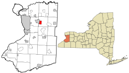
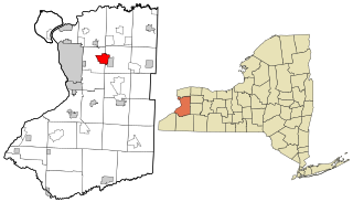
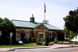
Williamsville is a village in Erie County, New York, United States. The population was 5,423 at the 2020 census. The village is named after Jonas Williams, an early settler. It is part of the Buffalo-Niagara Falls metropolitan area.

<span class="mw-page-title-main">Brockport, New York</span> Village in New York, United States

Brockport is a village in the Town of Sweden, with two tiny portions in the Town of Clarkson, in Monroe County, New York, United States. The population was 7,104 at the 2020 U.S. Census. The name is derived from Heil Brockway, an early settler. It is also home to SUNY Brockport.

<span class="mw-page-title-main">Nyack, New York</span> Village in New York, United States

Nyack is a village located primarily in the town of Orangetown in Rockland County, New York, United States. Incorporated in 1872, it retains a very small western section in Clarkstown. The village had a population of 7,265 as of the 2020 census. It is a suburb of New York City lying approximately 15 miles (24 km) north of the Manhattan boundary near the west bank of the Hudson River, situated north of South Nyack, east of Central Nyack, south of Upper Nyack, and southeast of Valley Cottage.

<span class="mw-page-title-main">Hornell, New York</span> City in New York, United States

Hornell is a city in Steuben County, New York, United States. The population was 8,259 at the 2020 census. The city is named after the Hornell family, early settlers.

<span class="mw-page-title-main">Trumansburg, New York</span> Village in New York, United States

Trumansburg is a village in Tompkins County, New York, United States. The population was 1,797 at the 2010 census. The name incorporates a misspelling of the surname of the founder, Abner Treman. The Tremans spelled their surname several different ways; "Truman," however, was not one of them. The village's application for a post office established the present spelling. The Village of Trumansburg is located within the Town of Ulysses and is northwest of Ithaca, New York.

<span class="mw-page-title-main">Alden, New York</span> Town in New York, United States

Alden is a town in Erie County, New York, United States. The population was 10,865 at the 2010 census. The town is derived from a family name known to early settlers.

<span class="mw-page-title-main">Cheektowaga, New York</span> Town in New York, United States

Cheektowaga is a town in Erie County, New York, United States. As of the 2020 census, the town has grown to a population of 89,877. The town is in the north-central part of the county, and is an inner ring suburb of Buffalo. The town is the second-largest suburb of Buffalo, after the Town of Amherst.

<span class="mw-page-title-main">Hamburg (village), New York</span> Village in New York, United States

Hamburg is a village in Erie County, New York, United States. The population was 9,696 at the 2020 census. The village is named after Hamburg, a city in Germany. It is part of the Buffalo-Niagara Falls metropolitan area.

<span class="mw-page-title-main">Lancaster, New York</span> Town in New York, United States

Lancaster is a town in Erie County, New York, United States, centered 14 miles east of downtown Buffalo. Lancaster is an outer ring suburb of Buffalo. As of the 2020 Census, the town population was 45,106.

<span class="mw-page-title-main">Orchard Park, New York</span> Town in New York, United States

Orchard Park is an incorporated town in Erie County, New York. It is an outer ring suburb southeast of Buffalo. As of the 2010 census, the population was 29,054, representing an increase of 5.13% from the 2000 census figure. The town contains a village also named Orchard Park. Orchard Park is one of the Southtowns of Erie County and is best known as the site of Highmark Stadium, home of the National Football League's Buffalo Bills.

<span class="mw-page-title-main">New York State Route 5</span> State highway in New York, US

New York State Route 5 (NY 5) is a state highway that extends for 370.80 miles (596.74 km) across the state of New York in the United States. It begins at the Pennsylvania state line in the Chautauqua County town of Ripley and passes through Buffalo, Syracuse, Utica, Schenectady, and several other smaller cities and communities on its way to downtown Albany in Albany County, where it terminates at U.S. Route 9 (US 9), here routed along the service roads for Interstate 787 (I-787). Prior to the construction of the New York State Thruway, it was one of two main east–west highways traversing upstate New York, the other being US 20. West of New York, the road continues as Pennsylvania Route 5 (PA 5) to Erie.

Cayuga Creek is a small stream in western New York, United States, with stretches in both Erie County and Wyoming County. The creek enters Buffalo Creek in the northwest corner of the Town of West Seneca in Erie County, just upstream from the New York State Thruway crossing. At that point, Buffalo Creek becomes the Buffalo River and flows into Lake Erie near Buffalo, New York.

<span class="mw-page-title-main">Proposed expansion of the Buffalo Metro Rail</span> Grass-roots organization in Buffalo, New York

Since the Buffalo Metro Rail light rail was proposed in the 1970s, there have been multiple proposals for expanding the system, which is currently a single 6.4-mile (10.3 km) long line. Public officials, agencies and advocacy groups have created plans, with the most recent and extensive being an extension to the town of Amherst. Groups have formed on both sides of the issue.

<span class="mw-page-title-main">Snyder, New York</span> Hamlet in New York, United States

Snyder is a hamlet within the town of Amherst in Erie County, New York, that is part of the Buffalo–Niagara Falls metropolitan area. The hamlet was established in 1837. It was named for Michael Snyder, its first postmaster, who also operated a store at the corner of Harlem Road, which is also known as New York State Route 240, and Main Street, which is also known as New York State Route 5. The hamlet blossomed due to retail activity demand created along the Main Street transportation route between Buffalo and points to the east in the 19th and early 20th century.

<span class="mw-page-title-main">New York State Route 952Q</span>

New York State Route 952Q (NY 952Q) is an unsigned reference route designation for the portion of Walden Avenue outside of the Buffalo city limits in Erie County, New York, in the United States. The western terminus of the 14-mile (23 km) route is at the Buffalo city line in Cheektowaga, where Walden Avenue continues west toward downtown Buffalo. Its eastern terminus is at Genesee Street in Alden, where NY 33 and Genesee Street continue on the linear northeasterly path followed by Walden Avenue for most of its routing.

References

  1. "ArcGIS REST Services Directory". United States Census Bureau. Retrieved September 20, 2022.
  2. "Board Members". Village of Lancaster, NY. Retrieved April 28, 2021.
  3. "US Gazetteer files: 2010, 2000, and 1990". United States Census Bureau. February 12, 2011. Retrieved April 23, 2011.
  4. "National Register Information System". National Register of Historic Places . National Park Service. July 9, 2010.
  5. "Census of Population and Housing". Census.gov. Retrieved June 4, 2015.
  6. "U.S. Census website". United States Census Bureau . Retrieved January 31, 2008.