Williamsville, New York

Last updated

Williamsville
Williamsville NY 5.jpg
Downtown Williamsville along NY 5
Erie County New York incorporated and unincorporated areas Williamsville highlighted.svg
Location in Erie County and New York
Coordinates: 42°57′45″N78°44′33″W / 42.96250°N 78.74250°W / 42.96250; -78.74250
Country United States
State New York
County Erie
Towns Amherst
Named for Jonas Williams
Government
   Mayor Christine L. Hunt
Area
[1]
  Total1.27 sq mi (3.28 km2)
  Land1.26 sq mi (3.26 km2)
  Water0.01 sq mi (0.02 km2)
Elevation
676 ft (206 m)
Population
 (2020)
  Total5,423
  Density4,310.81/sq mi (1,664.45/km2)
Time zone UTC-5 (Eastern (EST))
  Summer (DST) UTC-4 (EDT)
ZIP codes
14221, 14231
Area code 716
FIPS code 36-82084 [2]
GNIS feature ID0971319 [3]
Website www.walkablewilliamsville.com

Williamsville is a village in Erie County, New York, United States. The population was 5,423 at the 2020 census. The village is named after Jonas Williams, an early settler. It is part of the Buffalo-Niagara Falls metropolitan area.

Contents

Williamsville is located mostly within the town of Amherst, but Creek Road and Creek Heights in the south part of the village (near the Wehrle Drive underpass of the New York State Thruway) are in the town of Cheektowaga. The village is in the northeastern quadrant of Erie County.

The Williamsville Central School District is a school system covering Williamsville, most of the eastern part of Amherst, and a small portion of the western end of Clarence.

History

The community developed where the major road between Batavia and Buffalo crossed Ellicott Creek just above Glen Falls. The water power offered by the waterfall attracted millers. The first mill was built by Jonas Williams in 1811, giving the village its first name, "Williams Mills". It still stands today, next to Glen Park, and is known as the Williamsville Water Mill.

Several other mills were built near Glen Falls during the 19th century. In 1841, a raceway was constructed to divert water from Ellicott Creek to the mills, creating an island known today as Island Park. [4] A stagecoach stop, tavern, and inn was built along the main road near Ellicott Creek by Oziel Smith in 1827. Today it is known as the Eagle House. [5] The close crossing of the main road and Ellicott Creek's Glen Falls was the initial attraction, around which Williamsville grew. The village was incorporated in 1850.

Ss. Peter and Paul Church was loosely operating in the early 1820s, and the current church construction began in 1834 following the sale of land for the church from a non-parishioner, Oziel Smith, and was finished in 1836. St. John Neumann arrived to lead Ss. Peter and Paul Catholic Church from 1836 to 1840. Ss. Peter and Paul School was started by St. John Neumann in 1836, who also served as one of its first teachers. [6]

During the War of 1812, American troops were stationed in Williamsville in the area between Garrison Road and Ellicott Creek. American soldiers and British prisoners were treated in a field hospital and log barracks that lined Garrison Road. A small cemetery, located on Aero Drive between Wehrle and Youngs Road, was used to bury the men who did not survive. General Winfield Scott used the Evans House as his headquarters in the Spring of 1813 when his entire army of 5,000–6,000 men were stationed in Williamsville. In 1813, when the British burned Buffalo, people fled to the safety of Williamsville, nearby Harris Hill, and Erie, Pennsylvania.

The village of Williamsville was one of more than 550 villages incorporated by New York State in 1850.

In 1983, Williamsville passed a Historic Preservation Code "to promote the awareness of landmarks of historic, cultural, social and architectural significance in the Village of Williamsville and to safe guard the heritage, character and quality of life unique to the Village through the preservation of these landmarks." [7]

Every summer in Williamsville, Old Home Days [8] is held in Island Park, located directly on Main Street in the village. The Carnival begins with a parade on the opening Tuesday, and for four days, thousands of people enjoy rides, food, and the people of Williamsville. The Old Home Days festival is in remembrance of several women who in the mid-19th century came to the park once each summer to drink tea and catch up on the years past.

In 2010, government downsizing activist Kevin Gaughan campaigned to dissolve the village government. After a highly contentious campaign, a dissolution referendum was held on August 17, 2010, where voters rejected dissolution by a 5–1 margin. [9]

Geography

Glen Falls on Ellicott Creek in Williamsville Glen Falls WilliamsvilleNY Aug2021 TimLaFaveJr.jpg
Glen Falls on Ellicott Creek in Williamsville

According to the United States Census Bureau, the village has a total area of 1.2 square miles (3.1 km2), all land.

Ellicott Creek flows through the village from south to north. The Onondaga Escarpment runs through the village east to west. Glen Falls marks the place where Ellicott Creek falls over the escarpment. An early name for Ellicott Creek was "Eleven Mile Creek".

Main Street is part of the east–west New York State Route 5 (NY 5). American surveyor Joseph Ellicott had the "Great Iroquois Trail", an ancient path from the Hudson River to Lake Erie, improved. It was known as the "Buffalo Road" and, later, "Main Street". North Union Road, part of NY 277, is a major north–south road through the west end of the village. Transit Road, surveyed by Joseph Ellicott, was named for an important surveying instrument (a transit level). Transit Road marks the boundary between townships (Amherst and Clarence, Cheektowaga and Lancaster), inter alia. Joseph Ellicott's surveys of western New York divided the Holland Purchase land into a grid of more or less square of townships with boundaries aligned north–south and east–west, a system related to the Public Land Survey System (PLSS) used in most of the rest of post-colonial America. In western New York, strict accordance to the PLSS was not required or followed, since the land was not federally owned, but had passed directly from the Seneca Indians to land speculators such as the Holland Land Company.

The New York State Thruway (Interstate 90 or I-90) passes through the south part of the village and connects to I-290. A Thruway toll plaza located near the village has been a matter of controversy for years and recent proposals suggest it may be moved farther east.

Demographics

Historical population
CensusPop.Note
1870 912
1880 880−3.5%
1900 905
1910 1,10522.1%
1920 1,66750.9%
1930 3,11987.1%
1940 3,61415.9%
1950 4,64928.6%
1960 6,31635.9%
1970 6,8788.9%
1980 6,017−12.5%
1990 5,583−7.2%
2000 5,573−0.2%
2010 5,300−4.9%
2020 5,4232.3%
U.S. Decennial Census [10]

As of the 2020 US Census [10] there were 5,423 people, 2,364 households, 1,308 families residing in the village, 594 with own children under 18 years. The population density was 4,283.6 people/mi2 (1,653.9 /km2). The racial makeup of the village was 86.4% White, 4.6% Asian, 3.6% African American, 0.13% Native American, 0.83% of other races, and 4.7% of two or more races. Hispanic or Latino of any race were 2.7% of the population.

There were 2,364 households, out of which 27.2% had children under the age of 18 living with them, 9.9% had a female householder with no husband present, and 44.7% were non-families. 37.3% of all households were made up of individuals, and 22.4% had someone living alone who was 65 years of age or older. The average household size was 2.11 and the average family size was 2.83.

In the village, the population was spread out, with 18.7% under the age of 19, 6.0% from 20 to 24, 23.2% from 25 to 44, 23.5% from 45 to 64, and 24.4% who were 65 years of age or older, with a median age of 45. The population was 47.3% male and 52.7% female.

According to the 2000 US Census, there were 2,695 housing units at an average density of 2,107.0 per square mile (813.5/km2). The median income for a household in the village was $47,557, and the median income for a family was $65,300. Males had a median income of $43,500 versus $32,172 for females. The per capita income for the village was $27,177. About 2.5% of families and 4.5% of the population were below the poverty line, including 2.7% of those under age 18 and 4.7% of those age 65 or over.

In 2007 it was found that the violent crimes per 1,000 residents were measured at 1.13, where as the national median was 4.0, property crimes (per 1000) were at 16.98, the national average was 29.4, and crimes per square mile were at 13, the national average was at 39.3.

Arts and culture

Williamsville Water Mill Williamsville Water Mill as seen from Glen Park, Williamsville, New York (01).jpg
Williamsville Water Mill

Landmarks

Williamsville has several parks. Glen Park, 10 acres (4.0 ha) (the site of an amusement park in the 1940s and 1950s), offers views of Ellicott Creek as it falls over the Onondaga Escarpment, forming the 27-foot-high (8.2 m) Glen Falls; Island Park has a large pavilion and is the site of Old Home Days and the Taste of Williamsville events during the summer.

There are 34 sites in Williamsville designated as landmarks by the village's Historic Preservation Commission [11] The Williamsville Christian Church and the Williamsville Water Mill Complex are listed on the National Register of Historic Places. [12]

Festival

The main festival in Williamsville is Old Home Days [13] and there also is the Taste of Williamsville. During the summer there is Music on Main, a musical festival hosted by several businesses on Main Street where local bands play on street corners during various days.

Parks and recreation

Recreational facilities in town include a rollerskating rink and the 1.5-mile (2.4 km) Lehigh Memory Trail. [14]

Education

Children of school age may attend public schools within the Williamsville Central School District, whose boundaries cover the entire village as well as much of the adjacent unincorporated Town of Amherst. Williamsville Central operates six elementary (grades K-4), four middle (5-8), and three high (9-12) schools. Of those, Village of Williamsville children are districted to Forest Elementary, Mill Middle, and Williamsville South High School.

The private schools of Williamsville include Saints Peter and Paul, as well as Christian Central Academy.

Notable people

Related Research Articles

<span class="mw-page-title-main">Erie County, New York</span> County in New York, United States

Erie County is a county along the shore of Lake Erie in western New York State. As of the 2020 census, the population was 954,236. The county seat is Buffalo, which makes up about 28% of the county's population. Both the county and Lake Erie were named for the regional Iroquoian language-speaking Erie tribe of Native Americans, who lived in the area before 1654. They were later pushed out by the more powerful Iroquoian nations tribes. The county is part of the Western New York region of the state.

<span class="mw-page-title-main">Amherst, New York</span> Town in New York, United States

Amherst is a town in Erie County, New York, United States. It is a suburb of Buffalo. As of 2020, the town had a total population of 129,595. This represents an increase from 122,366 as reported in the 2010 census. It is the 14th most populated City/Town in New York.

<span class="mw-page-title-main">Clarence, New York</span> Town in New York, United States

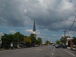
Clarence is a town and affluent suburb located in the northeastern part of Erie County, New York, United States, northeast of Buffalo. The population was 32,950 according to the 2020 census estimate. This represents an increase of 7.4% from the 2010 census figure. The Clarence census-designated place occupies the southeast part of the town and roughly corresponds to a postal district with ZIP code 14031 and 14221 in the western side which it shares with nearby Williamsville. The town is named in honor of Prince William, Duke of Clarence and St Andrews (1765–1837), the third son of King George III and later king himself, as William IV.

<span class="mw-page-title-main">Evans, New York</span> Town in New York, United States

Evans is a town in Erie County, New York, United States. The population was 16,356 at the 2010 census. The town derives its name from David E. Evans, an agent of the Holland Land Company and nephew of land agent Joseph Ellicott.

<span class="mw-page-title-main">Newstead, New York</span> Town in New York, United States

Newstead is the northeasternmost town in Erie County, New York, United States. The population was 8,689 at the 2020 census. The name is reportedly derived from Newstead Abbey in England.

<span class="mw-page-title-main">Cheektowaga, New York</span> Town in New York, United States

Cheektowaga is a town in Erie County, New York, United States. As of the 2020 census, the town has grown to a population of 89,877. The town is in the north-central part of the county, and is an inner ring suburb of Buffalo. The town is the second-largest suburb of Buffalo, after the Town of Amherst.

<span class="mw-page-title-main">Lancaster, New York</span> Town in New York, United States

Lancaster is a town in Erie County, New York, United States, centered 14 miles east of downtown Buffalo. Lancaster is an outer ring suburb of Buffalo. As of the 2020 Census, the town population was 45,106.

<span class="mw-page-title-main">Orchard Park, New York</span> Town in New York, United States

Orchard Park is an incorporated town in Erie County, New York, United States. It is an outer ring suburb southeast of Buffalo. As of the 2010 census, the population was 29,054, representing an increase of 5.13% from the 2000 census figure. The town contains a village also named Orchard Park. Orchard Park is one of the Southtowns of Erie County and is best known as the site of Highmark Stadium, home of the National Football League's Buffalo Bills.

<span class="mw-page-title-main">Tonawanda (town), New York</span> Town in New York, United States

Tonawanda is a town in Erie County, New York, United States. As of the 2020 census, the town had a population of 72,636. The town is at the north border of the county and is the northern inner ring suburb of Buffalo. It is sometimes referred to, along with its constituent village of Kenmore, as "Ken-Ton". The town was established in 1836, and up to 1903 it included what is now the city of Tonawanda.

<span class="mw-page-title-main">New York State Route 5</span> State highway in New York, US

New York State Route 5 (NY 5) is a state highway that extends for 370.80 miles (596.74 km) across the state of New York in the United States. It begins at the Pennsylvania state line in the Chautauqua County town of Ripley and passes through Buffalo, Syracuse, Utica, Schenectady, and several other smaller cities and communities on its way to downtown Albany in Albany County, where it terminates at U.S. Route 9 (US 9), here routed along the service roads for Interstate 787 (I-787). Prior to the construction of the New York State Thruway, it was one of two main east–west highways traversing upstate New York, the other being US 20. West of New York, the road continues as Pennsylvania Route 5 (PA 5) to Erie.

Amherst State Park is an 80-acre (0.32 km2) park in Erie County, New York, United States. The park is located northeast of Buffalo, partially in the Village of Williamsville with the balance located in the Town of Amherst. The park is managed by the Town of Amherst under an agreement with the New York State Office of Parks, Recreation and Historic Preservation.

<span class="mw-page-title-main">Ellicott Creek</span> River in New York, United States

Ellicott Creek is a stream in Western New York, United States. It is a tributary of Tonawanda Creek, which in turn flows into the Niagara River.

<span class="mw-page-title-main">New York State Route 324</span> State highway in western New York, US

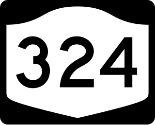
New York State Route 324 (NY 324) is an east–west state highway located in the western portion of New York in the United States. Officially, NY 324 begins at NY 384 in Niagara Falls and overlaps Interstate 190 south to Grand Island, where it separates from I-190 and continues southward as Grand Island Boulevard. As signed, however, NY 324 begins at the southern end of the official overlap and is contained entirely within Erie County. At the southern edge of Grand Island, NY 324 joins I-190 to cross over to the mainland, where it runs due east across three towns before reaching its eastern end at a junction with NY 5 in the town of Clarence.

<span class="mw-page-title-main">New York State Route 277</span> State highway in Erie County, New York, US

New York State Route 277 (NY 277) is a state highway in New York in the United States. This highway is also called Union Road, along with other names. NY 277 is a major north–south road east of Buffalo, New York, through the middle of Erie County. The section of NY 277 north of Orchard Park used to be New York State Route 18B until the portion of NY 18 south of Niagara Falls was deleted on January 1, 1962.

<span class="mw-page-title-main">New York State Route 240</span> State highway in western New York, US

New York State Route 240 (NY 240) is a 51.64-mile (83.11 km) state highway in western New York in the United States. The southern terminus of the route is at an intersection with NY 242 in the Ellicottville community of Ashford Junction in northern Cattaraugus County. Its northern terminus is at a junction with NY 324 and Interstate 290 (I-290) in Amherst in northern Erie County. The route passes through the villages of Springville and Orchard Park, where it meets NY 39 and U.S. Route 20A (US 20A), respectively. Much of NY 240 between Concord and Aurora follows the west branch of Cazenovia Creek. The northern part of NY 240 in Erie County, named Harlem Road, is a major north–south route through the suburbs east of the city of Buffalo.

<span class="mw-page-title-main">Snyder, New York</span> Hamlet in New York, United States

Snyder is a hamlet within the town of Amherst in Erie County, New York, that is part of the Buffalo–Niagara Falls metropolitan area. The hamlet was established in 1837. It was named for Michael Snyder, its first postmaster, who also operated a store at the corner of Harlem Road, which is also known as New York State Route 240, and Main Street, which is also known as New York State Route 5. The hamlet blossomed due to retail activity demand created along the Main Street transportation route between Buffalo and points to the east in the 19th and early 20th century.

<span class="mw-page-title-main">Getzville, New York</span> Hamlet in New York, United States

Getzville is a hamlet in the town of Amherst in Erie County, New York, United States. Getzville's ZIP code is 14068, and its post office is located on Millersport Highway.

<span class="mw-page-title-main">Glen Falls (New York)</span> Waterfall in NY, U.S.

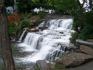
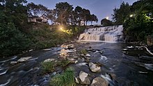
Glen Falls is a small waterfall located on Ellicott Creek in the village of Williamsville, New York. The hydropower provided by the falls made it an ideal site for a number of early watermills used to grind grist and to power sawmills.

<span class="mw-page-title-main">U.S. Route 62 in New York</span> Segment of American highway

U.S. Route 62 is a part of the U.S. Highway System that travels from the United States–Mexico border at El Paso, Texas, to Niagara Falls, New York. In the U.S. state of New York, US 62 extends 102.77 miles (165.39 km) from the New York–Pennsylvania border south of Jamestown to an intersection with New York State Route 104 in downtown Niagara Falls, bypassing the city of Jamestown and serves the cities of Buffalo and Niagara Falls, along with several villages. It is the only north–south mainline U.S. highway in Western New York. US 62 was extended into New York c. 1932 and originally was concurrent with the state highways that had previously been designated along its routing—namely NY 18, NY 60, NY 83 and NY 241. These concurrencies were eliminated individually during the 1940s and 1960s. The last of the four concurrencies, with NY 18 from Dayton to Niagara Falls, was removed c. 1962. US 62 has one special route, US 62 Business, located in Niagara Falls. US 62 Business is a former routing of US 62 within the city and was once NY 62A.

Bowmansville is a hamlet located in the town of Lancaster in Erie County, New York, United States. It is named after Benjamin Bowman, the owner of sawmills on Ellicott Creek in the center of the hamlet.

References

  1. "ArcGIS REST Services Directory". United States Census Bureau. Retrieved September 20, 2022.
  2. "U.S. Census website". United States Census Bureau . Retrieved January 31, 2008.
  3. "US Board on Geographic Names". United States Geological Survey. October 25, 2007. Retrieved January 31, 2008.
  4. "Island Park". Walkable Williamsville.
  5. "Eagle Hotel, Main Street, Williamsville". Buffalo Architecture and History.
  6. ""SS. Peter and Paul Church of Williamsville NY, Parish History"".
  7. "History". Village of Williamsville. Retrieved October 27, 2022.
  8. Welcome to OldHomeDays.org!
  9. "WBFO: Village dissolution rejected in Williamsville and Sloan (2010-08-18)". www.publicbroadcasting.net. Archived from the original on September 5, 2010.
  10. 1 2 "Census of Population and Housing". Census.gov. Retrieved October 28, 2022.
  11. "Historic Preservation - Village of Williamsville".
  12. "National Register Information System". National Register of Historic Places . National Park Service. July 9, 2010.
  13. ""Old Home Days, Wiliamsville, NY"".
  14. "Lehigh Memory Trail". Walkable Williamsville. Retrieved October 27, 2022.
  15. Hevesi, Dennis. "Dr. Thomas Dao, Expert on Treatment of Breast Cancer, Dies at 88", The New York Times , July 25, 2009. Accessed July 26, 2009.