Holland, New York

Last updated

Holland
Town of Holland
North Main Street, Holland, New York - 20210610.jpg
View along Main Street in the town center as seen in June 2021
Erie County New York incorporated and unincorporated areas Holland highlighted.svg
Location in Erie County and the state of New York.
New York in United States (US48).svg
Location of New York in the United States
Coordinates: 42°38′28″N78°32′28″W / 42.64111°N 78.54111°W / 42.64111; -78.54111
CountryUnited States
State New York
County Erie County
Incorporated1818
Named for Holland Land Company
Government
  MayorMichael C. Kasprzyk (R)
  • Geoffrey W. Hack (R)
  • Karen L. Kline (R)
  • Roberta A. Herr (R)
  • James E. Britt (R)
Area
[1]
  Total35.83 sq mi (92.79 km2)
  Land35.79 sq mi (92.70 km2)
  Water0.04 sq mi (0.09 km2)
Elevation
1,529 ft (466 m)
Population
 (2010)
  Total3,401
  Estimate 
(2016) [2]
3,374
  Density94.27/sq mi (36.40/km2)
Time zone UTC-5 (EST)
  Summer (DST) UTC-4 (EDT)
ZIP code
14080
Area code 716
FIPS code 36-029-35122
FIPS code 36-35122
GNIS feature ID979070
Website www.townofhollandny.com

Holland is a town in Erie County, New York, United States. The population was 3,401 at the 2010 census. The name is derived from the Holland Land Company, the original title-holder to most of the land of Western New York.

Contents

Holland is one of the "Southtowns" of Erie County, located in the southeast part of the county, and to the southeast of Buffalo.

History

The town was first settled along its northern border, then called "Humphrey Valley", in 1807.

The town of Holland was established in 1818 from part of the (now defunct) town of Willink, which once included all the southern part of Erie County. The name was derived from Willem Willink, one of the original investors of the Holland Land Company, which owned most of the land in western New York and sold it off to cities and townships that exist today. The name "Holland" is one of many surviving remnants of the Dutch investors who once owned this region. As with the town of Willink, the locations named after these investors have been given new names. Many of the original town buildings met their fate due to fire. Today the Holland Historical Society resides in the original fire hall on Main Street.

Geography

According to the United States Census Bureau, the town has a total area of 35.8 square miles (92.8 km2), of which 35.8 square miles (92.7 km2) is land and 0.04 square miles (0.1 km2), or 0.10%, is water.

The east town line is the border of the town of Java in Wyoming County.

New York State Route 16 is a major north–south highway through the town.

The East Branch of Cazenovia Creek flows northward through Holland.

Holland Central Schools

Established in 1933, the school was centralized and a new building was put up on 103 Canada Street. Students left the old school, located today where the town hall resides, after Christmas break of 1932, and moved into the new establishment in January. The Harold O. Brumstead elementary building was added in 1960, and a middle school was built in 1973 on the corner of Partridge and Route 16. The original building on Canada Street is currently the Holland Junior/Senior High School.

In November 1982, Holland's boys varsity soccer team tied Mattituck, 1-1, in the state Class C soccer finals, earning the school's first state title in any sport. As of 2010, only one other Section 6 boys soccer team since 1978 (North Collins, Class D, 1994) had won a NYSPHSAA crown.

Notable people

Events

Demographics

Historical population
CensusPop.Note
1820 768
1830 1,07039.3%
1840 1,24216.1%
1850 1,3155.9%
1860 1,53817.0%
1870 1,451−5.7%
1880 1,72018.5%
1890 1,595−7.3%
1900 1,434−10.1%
1910 1,4682.4%
1920 1,410−4.0%
1930 1,4734.5%
1940 1,4961.6%
1950 1,72815.5%
1960 2,30433.3%
1970 3,14036.3%
1980 3,4469.7%
1990 3,5723.7%
2000 3,6030.9%
2010 3,401−5.6%
2016 (est.)3,374 [2] −0.8%
U.S. Decennial Census [5]

As of the census [6] of 2000, there were 3,603 people, 1,332 households, and 981 families residing in the town. The population density was 100.7 inhabitants per square mile (38.9/km2). There were 1,408 housing units at an average density of 39.3 per square mile (15.2/km2). The racial makeup of the town was 98.17% White, 0.50% Black or African American, 0.31% Native American, 0.39% Asian, 0.14% from other races, and 0.50% from two or more races. Hispanic or Latino of any race were 0.36% of the population.

There were 1,332 households, out of which 36.6% had children under the age of 18 living with them, 62.3% were married couples living together, 8.2% had a female householder with no husband present, and 26.3% were non-families. 20.4% of all households were made up of individuals, and 8.5% had someone living alone who was 65 years of age or older. The average household size was 2.70 and the average family size was 3.16.

In the town, the population was spread out, with 27.7% under the age of 18, 6.9% from 18 to 24, 31.6% from 25 to 44, 23.9% from 45 to 64, and 9.9% who were 65 years of age or older. The median age was 36 years. For every 100 females, there were 99.1 males. For every 100 females age 18 and over, there were 99.8 males.

The median income for a household in the town was $46,708, and the median income for a family was $55,885. Males had a median income of $40,670 versus $25,886 for females. The per capita income for the town was $19,196. About 8.0% of families and 9.7% of the population were below the poverty line, including 12.0% of those under age 18 and 9.9% of those age 65 or over.

Communities and locations in Holland

See also

Related Research Articles

<span class="mw-page-title-main">Tortolita, Arizona</span> Former CDP in Arizona, United States

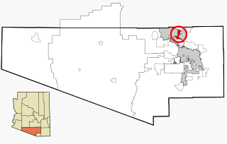
Tortolita was a census-designated place (CDP) in Pima County, Arizona, United States. The population was 3,740 at the 2000 census. Tortolita was situated between the growing incorporated towns of Oro Valley and Marana with most of the area previously part of the CDP having been annexed by the two towns during the 2000s. The remaining parts of the CDP that have not been annexed continue to be unincorporated portions of Pima County.

<span class="mw-page-title-main">Portland, New York</span> Town in New York, United States

Portland is a town in Chautauqua County, New York, United States. The population was 4,366 according to the 2020 census. The town is on the shore of Lake Erie southwest of Dunkirk.

<span class="mw-page-title-main">Livingston, New York</span> Town in Columbia County, New York, US

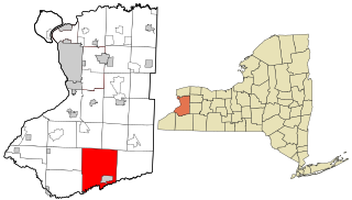
Livingston is a town in Columbia County, New York, United States. The population was 3,628 at the 2020 census. The town is named after its founding father.

<span class="mw-page-title-main">Aurora, Erie County, New York</span> Town in New York, United States

Aurora is a town in Erie County, New York, United States. The population was 13,782 at the 2010 census. It is one of the "Southtowns" of Erie County and is also erroneously called "East Aurora", the name of its principal village. The town is centrally located in the county, southeast of Buffalo.

<span class="mw-page-title-main">Brant, New York</span> Town in New York, United States

Brant is a town in Erie County, New York, United States. As of the 2010 U.S. census, the town had a population of 2,065. The town was named after the Mohawk leader Joseph Brant.

<span class="mw-page-title-main">Colden, New York</span> Town in New York, United States

Colden is a town in Erie County, New York, United States. The population was 3,265 at the 2010 census. The town derives its name from Cadwallader D. Colden, a state senator. Colden is an interior town in the southeastern part of the county. It is one of the "Southtowns" of Erie County.

<span class="mw-page-title-main">Concord, New York</span> Town in New York, United States

Concord is a town in Erie County, New York, United States. The population was 8,494 at the 2010 census. The town is believed to be named after Concord, Massachusetts, by early settlers from New England.

<span class="mw-page-title-main">Evans, New York</span> Town in New York, United States

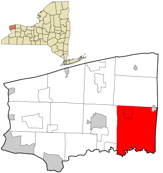
Evans is a town in Erie County, New York, United States. The population was 16,356 at the 2010 census. The town derives its name from David E. Evans, an agent of the Holland Land Company and nephew of land agent Joseph Ellicott.

<span class="mw-page-title-main">Sardinia, New York</span> Town in New York, United States

Sardinia is a town in Erie County, New York, United States. The town lies in the southeast corner of Erie County and is considered one of the county's "Southtowns". The town is southeast of Buffalo. The population was 2,775 at the 2010 census. The town is reportedly named after an old Christian hymn, Sardinia, and the homonymous Mediterranean island.

<span class="mw-page-title-main">Wales, New York</span> Town in New York, United States

Wales is a town in Erie County, New York, United States. The town is one of the "Southtowns" of Erie County by virtue of its position in the southeast part of the county, southeast of Buffalo. As of the 2010 census the town had a population of 3,005.

Lebanon is a town in Madison County, New York state, United States. The population was 1,332 at the 2010 census. The town is believed to be named after Lebanon, Connecticut.

<span class="mw-page-title-main">Cambria, New York</span> Town in New York, United States

Cambria is a town in Niagara County, New York, United States. The population was 5,743 at the 2020 census. Cambria is an early name for Wales.

<span class="mw-page-title-main">Royalton, New York</span> Town in New York, United States

Royalton is a town in Niagara County, New York, United States. The population was 7,660 at the 2010 census.

<span class="mw-page-title-main">Verona, New York</span> Town in New York, United States

Verona is a town in southwestern Oneida County, New York, United States. The population was 6,293 at the 2010 census. The town was named after Verona, Italy.

<span class="mw-page-title-main">Gaines, New York</span> Town in New York, United States

Gaines is a town in Orleans County, New York, United States. The population was 3,378 at the 2010 census. The town is named after General Edmund P. Gaines, who defended the area during the War of 1812.

<span class="mw-page-title-main">Schroeppel, New York</span> Town in New York, United States

Schroeppel is a town in Oswego County, New York, United States. The population was 8,501 at the 2010 census. The name derives from the Schroeppel family, early land owners of the area. Schroeppel is located in the southeast part of the county.

<span class="mw-page-title-main">Halfmoon, New York</span> Town in New York, United States

Halfmoon is a town in Saratoga County, New York, United States. The population was 25,662 at the 2020 census. The town is apparently named for the shape of the lower elevation land north of the junction of the Hudson and Mohawk Rivers. It is also said to be named for Henry Hudson's ship, the Halve Maen.

<span class="mw-page-title-main">Galen, New York</span> Town in New York, United States

Galen is a town in Wayne County, New York, United States. The population was 4,290 at the 2010 census. The town is named after the classical physician Galen.

<span class="mw-page-title-main">Ripley, New York</span> Town in New York, United States

Ripley is a town on Lake Erie in the westernmost part of Chautauqua County, New York, United States. The population was 2,310 at the time of the 2020 census. The town was named after Eleazer Wheelock Ripley, a general in the War of 1812. There are no incorporated villages in the town, but there is one census-designated place: the hamlet of Ripley. The town is perhaps best known as being the western terminus of the New York State Thruway.

<span class="mw-page-title-main">Eden, New York</span> Town in New York, United States

Eden is a town located south of Buffalo, in Erie County, New York, the United States. The population was 7,688 at the 2010 census. The basis for choosing the town's name is unknown.

References

  1. "2016 U.S. Gazetteer Files". United States Census Bureau. Retrieved July 4, 2017.
  2. 1 2 "Population and Housing Unit Estimates" . Retrieved June 9, 2017.
  3. Laura Louise Colby Ingalls on www.geni.com
  4. "A Biography of Frank Emerson Wheelock". Wheelock.lubbockisd.org. Retrieved July 3, 2015.
  5. "Census of Population and Housing". Census.gov. Retrieved June 4, 2015.
  6. "U.S. Census website". United States Census Bureau . Retrieved January 31, 2008.