
Akron is a village in Erie County, New York, United States. The population was 2,868 at the 2010 census. The name derives from the Greek word ἄκρον signifying a summit or high point. It is part of the Buffalo–Niagara Falls Metropolitan Statistical Area. Akron is located in the town of Newstead on the west and north slopes of a hill. NY 93 passes through the village.
Blasdell is a village in Erie County, New York, United States. The population was 2,553 according to the 2010 Census. The name is derived from Heman Blasdell, the first station master of the Erie and Pennsylvania railroad depot. It is part of the Buffalo–Niagara Falls Metropolitan Statistical Area.

Pembroke is a town in Genesee County, Western New York, United States. The population was 4,292 at the 2010 census. The town is named for a town in west Wales. Pembroke lies on the west border of Genesee County, west of Batavia.
South Wales, New York is a hamlet in the towns of Aurora and Wales in Erie County, New York, United States.
Swormville is a hamlet in the eastern part of Amherst and the western part of Clarence, New York, USA.
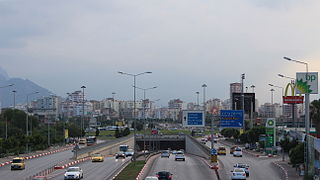
A roundabout interchange is a type of interchange between a controlled access highway, such as a motorway or freeway, and a minor road. The slip roads to and from the motorway carriageways converge at a single roundabout, which is grade-separated from the motorway lanes with bridges.

Cegielnia is a village in the administrative district of Gmina Tarłów, within Opatów County, Świętokrzyskie Voivodeship, in south-central Poland. It lies approximately 5 kilometres (3 mi) south of Tarłów, 27 km (17 mi) north-east of Opatów, and 78 km (48 mi) east of the regional capital Kielce.
Millhome is an unincorporated community in the town of Schleswig, Manitowoc County, Wisconsin, United States. The nearest city to Millhome is Kiel. The community is located just west of the intersection of Wisconsin Highway 32 and Wisconsin Highway 57 and is along the border between Manitowoc and Sheboygan Counties. The Sheboygan River passes through the community.

Graino is an unincorporated community in Colusa County, California. It lies at an elevation of 33 feet and is located at 39°02′09″N121°57′44″W.
Doyle is a hamlet in the town of Cheektowaga in Erie County, New York, United States. The southern half is part of the Kaisertown neighborhood, which includes portions of Cheektowaga, West Seneca, and South Buffalo.
Cleveland Hill is a hamlet in the town of Cheektowaga in Erie County, New York, US. It is the location of the Cleveland Hill School District. Cleveland Hill is often called Cleve Hill. The center of Cleveland Hill is located at Harlem Road and Cleveland Drive. Cleveland Hill is unique in that the Onondaga Escarpment runs through it with the elevation at Harlem Road and Cleveland Drive being 215 meters (705 ft). The elevation decreases as one heads north or south on Harlem Road. Only if one heads east towards the Buffalo Niagara International Airport does the elevation stay the same or increase slightly.

Grandyle Village is a hamlet and census-designated place (CDP) in the town of Grand Island in Erie County, New York, United States. As of the 2010 census, it had a population of 4,629.
Murrays Corner, New York is a hamlet in the town of Newstead in Erie County, New York, United States.
Sand Hill, New York is a hamlet in the town of Newstead in Erie County, New York, United States.
Swifts Mills, New York is a hamlet in the town of Newstead in Erie County, New York, United States.
Twin Lakes State Beach is a beach located on Monterey Bay in downtown Santa Cruz, in coastal Santa Cruz County, northern California.

Bresnica is a village in the municipality of Vranje, Serbia. According to the 2002 census, the village has a population of 410 people.
South Cheektowaga is a neighborhood on the West Seneca border near French Road, in the town of Cheektowaga, in Erie County, New York, United States.
Swastika is an unincorporated community in the town of Black Brook, Clinton County, New York, in the United States.
Five Points is an unincorporated community in southern Franklin County, North Carolina, United States. It is located west of Bunn, at an elevation of 282 feet. The primary cross roads where the community is located are N.C. Highway 98, Pearces Road and John Winstead Road.


