
Erie County is a county along the shore of Lake Erie in western New York State. As of the 2020 census, the population was 954,236. The county seat is Buffalo, which makes up about 28% of the county's population. Both the county and Lake Erie were named for the regional Iroquoian language-speaking Erie tribe of Native Americans, who lived in the area before 1654. They were later pushed out by the more powerful Iroquoian nations tribes.

Allendale is a census-designated place (CDP) in Ottawa County in the U.S. state of Michigan. The population was 17,579 at the 2010 census. It is located within Allendale Charter Township, occupying approximately the northern two-thirds of the township, from the eastern boundary with the Grand River west along Pierce St., north along 75th Ave., then west along Lake Michigan Drive (M-45) to the western boundary of the township. It is a part of the Grand Rapids-Muskegon-Holland, Michigan combined statistical area, and is an exurb of Grand Rapids, due to its major commuter routes into the city.

Pinardville is a census-designated place (CDP) in the town of Goffstown, Hillsborough County, New Hampshire, United States. It is a suburban neighborhood adjacent to the city of Manchester. The population was 5,034 at the 2020 census. Pinardville has existed since 1906.
Weston Mills is a hamlet in the towns of Portville and Olean in Cattaraugus County, New York, United States. It is counted as a census-designated place by the U.S. Census Bureau, which recorded a population of 1,472 at the 2010 census.

Billington Heights is a hamlet and census-designated place (CDP) in the towns of Elma and Aurora in Erie County, New York, United States. The population was 1,685 at the 2010 census. It is part of the Buffalo–Niagara Falls Metropolitan Statistical Area.

Elma Center is a hamlet and census-designated place (CDP) in the town of Elma in Erie County, New York, United States. As of the 2010 census, this community population was 2,571. It is part of the Buffalo–Niagara Falls Metropolitan Statistical Area.

Grand Island is an island town in Erie County, New York, United States. As of the 2020 census, the town's population was 21,389 representing an increase of 5.00% from the 2010 census figure. The town's name derives from the French name La Grande Île, as Grand Island is the largest island in the Niagara River and third largest in New York state. The phrase La Grande Île appears on the town seal.

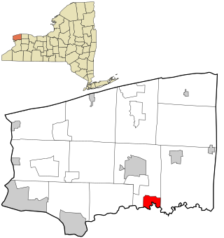
Town Line is a hamlet and census-designated place (CDP) in Erie County, New York, United States. The population was 2,367 at the 2010 census. It is part of the Buffalo–Niagara Falls Metropolitan Statistical Area. The community is located on the boundary between the towns of Lancaster and Alden. Town Line is notable for having held a nonbinding vote to secede from the United States in 1861, and for having held a ceremonial vote to rejoin the United States in 1946.

Olcott is a hamlet located in the Town of Newfane in Niagara County, New York, United States. As of the 2010 census, this community population was 1,241. Most locals refer to it as Olcott Beach. It is part of the Buffalo–Niagara Falls Metropolitan Statistical Area.
Rapids is a hamlet located in the Town of Lockport in Niagara County, New York, United States. The population was 1,636 at the 2010 census. The ZIP code for Rapids is 14094.

Cheektowaga is a suburban community and census-designated place (CDP) in Erie County, New York, United States. The population was 75,178 at the 2010 census, making it the most populous census-designated place in New York. It is within the town of Cheektowaga. The CDP includes Buffalo Niagara International Airport.

Eden is a hamlet and census-designated place (CDP) in Erie County, New York, United States. The population was 3,516 at the 2010 census. It is part of the Buffalo–Niagara Falls Metropolitan Statistical Area.

Holland is a hamlet and census-designated place (CDP) in Erie County, New York, United States. The population was 1,206 at the 2010 census. It is in the town of Holland and is part of the Buffalo–Niagara Falls Metropolitan Statistical Area.

Tonawanda is a census-designated place (CDP) in Erie County, New York, United States. The CDP comprises the town of Tonawanda minus its subsidiary village of Kenmore. As of the 2010 census, the CDP population was 58,144.

Eggertsville is a hamlet and census-designated place (CDP) within the town of Amherst in Erie County, New York, United States. The population of the CDP was 15,019 at the 2010 census.

Wanakah is a hamlet in the town of Hamburg in Erie County, New York, United States. As of the 2010 census, it had a population of 3,199.
Frizzleburg is an unincorporated community and census-designated place (CDP) in Lawrence County, Pennsylvania, United States. The population was 602 at the 2010 census.

Beaver Dam Lake is a census-designated place (CDP) in the towns of New Windsor, Blooming Grove, and Cornwall in Orange County, New York, United States. As of the 2020 census, it had a population of 2,609.
Lime Lake is a hamlet and census-designated place (CDP) in the northeast part of the town of Machias, in Cattaraugus County, New York, United States. As of the 2010 census, it had a population of 867. Prior to the 2010 census, the area was delineated as part of the Lime Lake-Machias CDP.

Clarence is a hamlet and census-designated place (CDP) within the town of Clarence in Erie County, New York, United States. The population was 2,646 at the 2010 census.

