Boston, New York

Last updated

Boston
Town of Boston
Erie County New York incorporated and unincorporated areas Boston highlighted.svg
Location in Erie County and the state of New York.
New York in United States (US48).svg
Location of New York in the United States
Coordinates: 42°37′44″N78°44′15″W / 42.62889°N 78.73750°W / 42.62889; -78.73750
CountryUnited States
State New York
County Erie County
Incorporated1817
Named for Boston, Massachusetts
Government
  SupervisorJason Keding (R)
  • Zachary Munger (R)
  • Mike Cartechine (C)
  • Jennifer Lucachik (R)
  • Kelly Martin(R)
  • Sandra Quinlan (R)
  • Debra Bender
Area
[1]
  Total35.82 sq mi (92.78 km2)
  Land35.82 sq mi (92.78 km2)
  Water0.00 sq mi (0.00 km2)
Elevation
925 ft (282 m)
Population
 (2020)
  Total7,948 Decrease2.svg
  Density225.01/sq mi (86.88/km2)
Time zone UTC-5 (EST)
  Summer (DST) UTC-4 (EDT)
ZIP code
14025
Area code 716
FIPS code 36-029-07454
Website www.townofboston.com

Boston is a town in Erie County, New York, United States. The population was 8,023 at the 2010 census. [2] The town is named after Boston, Massachusetts.

Contents

Boston is an interior town of the county and one of the county's "Southtowns". Boston is southeast of Buffalo.

History

The Iroquois, under various names, lived here until the European immigrants became predominant.

In 1804, brothers Charles and Oliver Johnson and their families became the area's first settlers. The first Christian church was the Free Will Baptist Church, founded circa 1811. On April 5, 1817, the town of Boston was formed from a portion of the town of Eden. The first post office opened in 1832 on the north side of town.

In 1843, the town suffered an epidemic (28 of the 43 residents were affected, 10 of whom died) believed to be typhoid fever, possibly from a local well. [3]

This town has much history that can be found on the headstones in the Maplewood Cemetery across from the Boston Town Hall. There are many old gravestones that show some of the first settlers in the town and the infamous "Love" murder. [4]

Geography

According to the United States Census Bureau, the town has a total area of 35.8 square miles (92.8 km2). [2]

Geologically speaking, Boston is one of the more interesting places in the Greater Niagara region, for many glacial activities, over many years, caused sufficient pressure indentation to alter dramatically the landscape and even the water table.

U.S. Route 219 crosses the town. New York State Route 277 (Boston State Road/Herman Hill Road) intersects New York State Route 391 (Boston State Road) in the northwestern part of the town at North Boston.

Demographics

Historical population
CensusPop.Note
1820 686
1830 1,520121.6%
1840 1,74514.8%
1850 1,8727.3%
1860 1,716−8.3%
1870 1,633−4.8%
1880 1,617−1.0%
1890 1,278−21.0%
1900 1,3989.4%
1910 1,5359.8%
1920 1,325−13.7%
1930 1,3683.2%
1940 1,71025.0%
1950 2,30234.6%
1960 5,106121.8%
1970 7,15840.2%
1980 7,6877.4%
1990 7,445−3.1%
2000 7,8976.1%
2010 8,0231.6%
2020 7,948−0.9%
U.S. Decennial Census [5]

As of the census [6] of 2000, there were 7,897 people, 2,997 households, and 2,244 families residing in the town. The population density was 220.4 inhabitants per square mile (85.1/km2). There were 3,122 housing units at an average density of 87.1 per square mile (33.6/km2). The racial makeup of the town was 98.91% white, 0.14% African American, 0.14% Native American, 0.20% Asian, 0.01% Pacific Islander, 0.10% from other races, and 0.49% from two or more races. Hispanic or Latino of any race were 0.72% of the population.

There were 2,997 households, out of which 33.3% had children under the age of 18 living with them, 64.6% were married couples living together, 7.0% had a female householder with no husband present, and 25.1% were non-families. 20.6% of all households were made up of individuals, and 8.8% had someone living alone who was 65 years of age or older. The average household size was 2.63 and the average family size was 3.06.

In the town, the population was spread out, with 25.2% under the age of 18, 6.3% from 18 to 24, 28.7% from 25 to 44, 27.1% from 45 to 64, and 12.7% who were 65 years of age or older. The median age was 40 years. For every 100 females, there were 100.8 males. For every 100 females aged 18 and over, there were 98.2 males.

The median income for a household in the town was $48,315, and the median income for a family was $57,714. Males had a median income of $42,101 versus $27,798 for females. The per capita income for the town was $21,303. About 3.6% of families and 5.9% of the population were below the poverty line, including 8.0% of those under age 18 and 4.5% of those age 65 or over.

Communities and locations in Boston

Notable people

Related Research Articles

<span class="mw-page-title-main">Dayton, New York</span> Town in New York, United States

Dayton is a town in Cattaraugus County, New York, United States. The population was 1,689 at the 2020 census. The town is on the western border of Cattaraugus County.

<span class="mw-page-title-main">Machias, New York</span> Town in New York, United States

Machias is a town in Cattaraugus County, New York, United States. The population was 2,309 at the 2020 census. Machias is an interior town in the northeast quadrant of the county. It is northeast of the city of Salamanca.

<span class="mw-page-title-main">Clymer, New York</span> Town in New York, United States

Clymer is a town in Chautauqua County, New York, United States. The population was 1,748 at the 2020 census. The town is named for George Clymer, a signer of the Declaration of Independence. Clymer is located in the southwest part of the county.

<span class="mw-page-title-main">Pomfret, New York</span> Town in New York, United States

Pomfret is a town in Chautauqua County, New York, United States. The population was 13.236 at the 2020 census. The town lies in the north-central part of the county, south of Dunkirk, and includes the village of Fredonia.

<span class="mw-page-title-main">Collins, New York</span> Town in New York, United States

Collins is a town in Erie County, New York, United States. The town is on the south border of the county and is considered to be one of the "Southtowns" of Erie County. The population at the 2010 census was 6,601.

<span class="mw-page-title-main">Concord, New York</span> Town in New York, United States

Concord is a town in Erie County, New York, United States. The population was 8,494 at the 2010 census. The town is believed to be named after Concord, Massachusetts, by early settlers from New England.

<span class="mw-page-title-main">Darien, New York</span> Town in Genesee County, New York

Darien is a town in Genesee County, New York, United States. The population was 3,158 at the 2010 census. Darien lies in the southwestern part of Genesee County, southwest of Batavia.

<span class="mw-page-title-main">Pembroke, New York</span> Town in New York, United States

Pembroke is a town in Genesee County, Western New York, United States. The population was 4,292 at the 2010 census. The town is named for a town in west Wales. Pembroke lies on the west border of Genesee County, west of Batavia.

<span class="mw-page-title-main">Royalton, New York</span> Town in New York, United States

Royalton is a town in Niagara County, New York, United States. The population was 7,660 at the 2010 census.

<span class="mw-page-title-main">Verona, New York</span> Town in New York, United States

Verona is a town in southwestern Oneida County, New York, United States. The population was 6,293 at the 2010 census. The town was named after Verona, Italy.

<span class="mw-page-title-main">Vienna, New York</span> Town in New York, United States

Vienna is a town in Oneida County, New York, United States. The population was 5,440 at the 2010 census. The town is named after the capital of Austria.

Seneca is a town in Ontario County, New York, United States. The population was 2,658 at the 2020 census. The town is named after a group of local natives.

<span class="mw-page-title-main">Sharon, New York</span> Town in New York, United States

Sharon is a town in Schoharie County, New York, United States. The population was 1,843 at the 2000 census. The town is named after a location in Connecticut, whence some early settlers came. The town of Sharon is in the northwestern corner of the county and is southwest of Amsterdam.

<span class="mw-page-title-main">Arcadia, New York</span> Town in New York, United States

Arcadia is a town in Wayne County, New York, United States. The population was 14,244 at the 2010 census.

<span class="mw-page-title-main">Galen, New York</span> Town in New York, United States

Galen is a town in Wayne County, New York, United States. The population was 4,290 at the 2010 census. The town is named after the classical physician Galen.

<span class="mw-page-title-main">Ripley, New York</span> Town in New York, United States

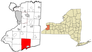
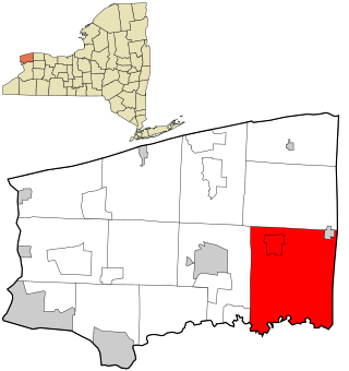
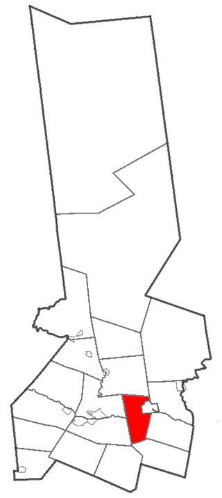
Ripley is a town on Lake Erie in the westernmost part of Chautauqua County, New York, United States. The population was 2,310 at the time of the 2020 census. The town was named after Eleazer Wheelock Ripley, a general in the War of 1812. There are no incorporated villages in the town, but there is one census-designated place: the hamlet of Ripley. The town is perhaps best known as being the western end of the New York State Thruway.

<span class="mw-page-title-main">North Collins, New York</span> Town in New York, United States

North Collins is a town in Erie County, New York, United States. The population was 3,523 at the 2010 census. The name is derived from its parent town, Collins.

<span class="mw-page-title-main">Frankfort, New York</span> Town in New York, United States

Frankfort is a town in Herkimer County, New York, United States. The town is named after one of its earliest settlers, Lawrence (Lewis) Frank. The town of Frankfort includes a village, also called Frankfort. Frankfort is located east of Utica, and the Erie Canal passes along its northern border. At the time of the 2010 census, the population was 7,636.

<span class="mw-page-title-main">Little Falls (town), New York</span> Town in New York, United States

Little Falls is a town in Herkimer County, New York, United States. The population was 1,587 at the 2010 census. The town is named after falls and rapids on the Mohawk River nearby.

<span class="mw-page-title-main">Eden, New York</span> Town in New York, United States

Eden is a town located south of Buffalo, in Erie County, New York, the United States. The population was 7,688 at the 2010 census. The basis for choosing the town's name is unknown.

References

  1. "2016 U.S. Gazetteer Files". United States Census Bureau. Retrieved July 4, 2017.
  2. 1 2 "Geographic Identifiers: 2010 Demographic Profile Data (G001): Boston town, Erie County, New York". U.S. Census Bureau, American Factfinder. Retrieved February 22, 2016.[ dead link ]
  3. spring 2022, Collaborative project in Plagues and Pandemics (HIS 390), University at Buffalo (SUNY) (January 11, 2023). "Typhoid in North Boston, NY, 1843: Small Town, Big Story". ArcGIS StoryMaps. Retrieved June 26, 2023.{{cite web}}: CS1 maint: multiple names: authors list (link)
  4. "The Sun and the Erie County Independent 11 Dec 2008, page Page 3". Newspapers.com. Retrieved June 26, 2023.
  5. "Census of Population and Housing". Census.gov. Retrieved June 4, 2015.
  6. "U.S. Census website". United States Census Bureau . Retrieved January 31, 2008.
  7. H. H. Miller, The World To-day: A Monthly Record of Human Progress, "Soldier, Millionaire and Philanthropist", Volume 16, 1909, page 440