Harris Hill, New York

Last updated

Harris Hill, New York
Erie County New York incorporated and unincorporated areas Harris Hill highlighted.svg
Location in Erie County and the state of New York
Coordinates: 42°58′1″N78°40′40″W / 42.96694°N 78.67778°W / 42.96694; -78.67778
Country United States
State New York
County Erie
Town Clarence
Named for Asa Harris
Area
[1]
  Total4.04 sq mi (10.46 km2)
  Land4.04 sq mi (10.46 km2)
  Water0.00 sq mi (0.00 km2)
Elevation
728 ft (222 m)
Population
 (2020)
  Total5,839
  Density1,445.30/sq mi (558.04/km2)
Time zone UTC-5 (Eastern (EST))
  Summer (DST) UTC-4 (EDT)
FIPS code 36-32391
GNIS feature ID0952264

Harris Hill is a hamlet and census-designated place (CDP) located in the town of Clarence in Erie County, New York, United States. The population was 5,508 at the 2010 census. It is part of the Buffalo-Niagara Falls metropolitan area. The region is named after Asa Harris, a former officer in the American Colonial Army, who established a tavern near the top of a low hill northeast of Buffalo.

Contents

Geography

Harris Hill is located at 42°58′1″N78°40′40″W / 42.96694°N 78.67778°W / 42.96694; -78.67778 (42.967058, -78.677828). [2] Harris Hill's ZIP code 14221 is shared with nearby Williamsville.

According to the United States Census Bureau, the CDP has a total area of 4.0 square miles (10 km2), all land.

Harris Hill is located in the southwest corner of the town, just north of the northern Lancaster town line, and is centered on the intersection of Main Street (NY Route 5) and Harris Hill Road.

Just to the southeast of Harris Hill, is a large crushed stone quarry located in the town of Lancaster. The quarry plunges some 30 meters into the bedrock. The quarry, now owned by Buffalo Crushed Stone, was opened in 1904. Buffalo Crushed Stone is located on the south side of Wehrle Drive, just east of Harris Hill Road in Lancaster.

History

Asa Harris's Tavern was a stop on the Underground Railroad. Freed slaves would sneak under Main Street (present-day NY Route 5) through limestone caves and exit north at the bottom of the Onondaga Formation into a swampy forest. The tavern has since been re-purposed as the Home Town Cleaners. It has since been renamed Reed's Laundry and Dry cleaning.

Demographics

Historical population
CensusPop.Note
2010 5,508
2020 5,8396.0%
U.S. Decennial Census [3]

As of the census [4] of 2000, there were 4,881 people, 1,859 households, and 1,435 families residing in the community. The population density was 1,207.0 inhabitants per square mile (466.0/km2). There were 1,992 housing units at an average density of 492.6 per square mile (190.2/km2). The racial makeup of the CDP was 97.38% White, 0.51% African American, 0.14% Native American, 1.25% Asian, 0.06% Pacific Islander, 0.39% from other races, and 0.27% from two or more races. Hispanic or Latino of any race were 0.82% of the population.

There were 1,859 households, out of which 32.7% had children under the age of 18 living with them, 67.6% were married couples living together, 6.7% had a female householder with no husband present, and 22.8% were non-families. 19.9% of all households were made up of individuals, and 11.0% had someone living alone who was 65 years of age or older. The average household size was 2.62 and the average family size was 3.04.

In the community, the population was spread out, with 25.4% under the age of 18, 5.0% from 18 to 24, 24.7% from 25 to 44, 26.1% from 45 to 64, and 18.8% who were 65 years of age or older. The median age was 42 years. For every 100 females, there were 93.8 males. For every 100 females age 18 and over, there were 92.3 males.

The median income for a household in the area was $62,500, and the median income for a family was $66,971. Males had a median income of $52,478 versus $31,910 for females. The per capita income for the CDP was $29,056. About 1.4% of families and 1.5% of the population were below the poverty line, including 0.7% of those under age 18 and 0.8% of those age 65 or over.

Related Research Articles

Rheems is an unincorporated community and census-designated place (CDP) in Lancaster County, Pennsylvania, United States, between the boroughs of Elizabethtown and Mount Joy. The population was 1,598 during the 2010 census.

<span class="mw-page-title-main">Napili-Honokowai, Hawaii</span> Census-designated place in Hawaii, United States

Napili-Honokowai is a census-designated place (CDP) in Maui County, Hawaii, United States. The population was 7,042 at the 2020 census.

South Sanford is a former census-designated place (CDP) in the city of Sanford in York County, Maine, United States. The population was 4,536 at the 2010 census. It is part of the Portland–South Portland–Biddeford, Maine Metropolitan Statistical Area. The CDP was abolished when the town of Sanford re-incorporated as a city.

<span class="mw-page-title-main">South Lancaster, Massachusetts</span> CDP in Massachusetts, United States

South Lancaster is a census-designated place (CDP) in the town of Lancaster and close to the Town of Clinton in Worcester County, Massachusetts, United States. The population was 1,894 at the 2010 census.

<span class="mw-page-title-main">Billington Heights, New York</span> Census-designated place in New York, United States

Billington Heights is a hamlet and census-designated place (CDP) in the towns of Elma and Aurora in Erie County, New York, United States. The population was 1,685 at the 2010 census. It is part of the Buffalo–Niagara Falls Metropolitan Statistical Area.

<span class="mw-page-title-main">Elma Center, New York</span> Census-designated place in New York, United States

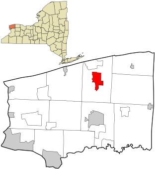
Elma Center is a hamlet and census-designated place (CDP) in the town of Elma in Erie County, New York, United States. As of the 2010 census, this community population was 2,571. It is part of the Buffalo–Niagara Falls Metropolitan Statistical Area.

<span class="mw-page-title-main">North Boston, New York</span> Census-designated place in New York, United States

North Boston is a hamlet and census-designated place (CDP) in the town of Boston in Erie County, New York, United States. As of the 2010 census, the CDP population was 2,521. It is part of the Buffalo–Niagara Falls Metropolitan Statistical Area.

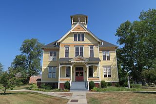
Tribes Hill is a census-designated place (CDP) located in the Towns of Mohawk (80%) and Amsterdam (20%) in Montgomery County, New York, United States. The population was 1,003 at the 2010 census. One theory is the name is based on this location having been a gathering spot for the Mohawk nation, the dominant Iroquois tribe in the area during colonial times. Tribes Hill spans the border of the Town of Mohawk and Town of Amsterdam, approximately five miles west of the City of Amsterdam on Route 5.

<span class="mw-page-title-main">South Hill, New York</span> CDP in New York, United States

South Hill is a census-designated place (CDP) in Tompkins County, New York, United States. The population was 7,245 at the 2020 census.

<span class="mw-page-title-main">Spring Hill, Pennsylvania</span>

Spring Hill is a census-designated place (CDP) in Cambria County, Pennsylvania, United States. The population was 839 at the 2010 census, down from 970 at the 2000 census.

<span class="mw-page-title-main">Aristes, Pennsylvania</span> Census-designated place in Pennsylvania, United States

Aristes is a census-designated place (CDP) in Conyngham Township, Columbia County, Pennsylvania, United States. It is part of Northeastern Pennsylvania. The population was 311 at the 2010 census. It is part of the Bloomsburg-Berwick micropolitan area. Aristes is located adjacent to the famous "ghost town" of Centralia.

<span class="mw-page-title-main">Rothsville, Pennsylvania</span> Census-designated place in Pennsylvania, United States

Rothsville is an unincorporated community and census-designated place (CDP) in Warwick Township, Lancaster County, Pennsylvania, United States. The population was 3,044 at the 2010 census. Lititz is the town for residents' mailing addresses.

<span class="mw-page-title-main">Kendall, Washington</span> CDP in Washington, United States

Kendall is a census-designated place (CDP) in Whatcom County, Washington, United States. The population was 191 at the 2010 census.

<span class="mw-page-title-main">Cheektowaga (CDP), New York</span> Census-designated place in New York, United States

Cheektowaga is a suburban community and census-designated place (CDP) in Erie County, New York, United States. The population was 75,178 at the 2010 census, making it the most populous census-designated place in New York. It is within the town of Cheektowaga. The CDP includes Buffalo Niagara International Airport.

<span class="mw-page-title-main">Eden (CDP), New York</span> Census-designated place in New York, United States

Eden is a hamlet and census-designated place (CDP) in Erie County, New York, United States. The population was 3,516 at the 2010 census. It is part of the Buffalo–Niagara Falls Metropolitan Statistical Area.

<span class="mw-page-title-main">Holland (CDP), New York</span> Census-designated place in New York, United States

Holland is a hamlet and census-designated place (CDP) in Erie County, New York, United States. The population was 1,206 at the 2010 census. It is in the town of Holland and is part of the Buffalo–Niagara Falls Metropolitan Statistical Area.

<span class="mw-page-title-main">Lancaster (village), New York</span> Village in New York, United States

Lancaster is a village in Erie County, New York, United States. As of the 2010 census, the village population was 10,352. It is part of the Buffalo-Niagara Falls metropolitan area.

<span class="mw-page-title-main">Tonawanda (CDP), New York</span> Census-designated place in New York, United States

Tonawanda is a census-designated place (CDP) in Erie County, New York, United States. The CDP comprises the town of Tonawanda minus its subsidiary village of Kenmore. As of the 2010 census, the CDP population was 58,144.

<span class="mw-page-title-main">Newfane (CDP), New York</span> CDP in New York, United States

Newfane is a census-designated place (CDP) in the town of Newfane in Niagara County, New York, United States, along State Route 78. The population was 3,822 at the 2010 census. It is part of the Buffalo–Niagara Falls Metropolitan Statistical Area.

<span class="mw-page-title-main">Shirley (CDP), Massachusetts</span> Census-designated place in Massachusetts, United States

Shirley is a census-designated place (CDP) comprising the main village in the town of Shirley in Middlesex County, Massachusetts, United States. The population was 1,611 at the 2020 census, out of 7,431 in the entire town of Shirley.

References

  1. "ArcGIS REST Services Directory". United States Census Bureau. Retrieved September 20, 2022.
  2. "US Gazetteer files: 2010, 2000, and 1990". United States Census Bureau. February 12, 2011. Retrieved April 23, 2011.
  3. "Census of Population and Housing". Census.gov. Retrieved June 4, 2016.
  4. "U.S. Census website". United States Census Bureau . Retrieved January 31, 2008.