Hamburg (village), New York

Last updated

Hamburg
Hamburg Village Hall; Hamburg, New York.png
Hamburg Village Hall
Motto: 
"Come to Discover. Stay for the Charm."
Erie County New York incorporated and unincorporated areas Hamburg (village) highlighted.svg
Location within Erie County and New York
Usa edcp location map.svg
Red pog.svg
Hamburg
Location within the United States
Coordinates: 42°43′22″N78°50′2″W / 42.72278°N 78.83389°W / 42.72278; -78.83389
Country United States
State New York
County Erie
Town Hamburg
Named for Hamburg, Germany
Government
  MayorThomas P. Tallman
Area
[1]
  Total2.48 sq mi (6.42 km2)
  Land2.48 sq mi (6.42 km2)
  Water0.00 sq mi (0.00 km2)
Elevation
820 ft (250 m)
Population
 (2020)
  Total9,696
  Density3,911.25/sq mi (1,509.94/km2)
Time zone UTC-5 (Eastern (EST))
  Summer (DST) UTC-4 (EDT)
ZIP codes
14075, 14219
Area code 716
FIPS code 36-31643
GNIS feature ID0952086
Website www.villagehamburg.com

Hamburg is a village in Erie County, New York, United States. The population was 9,696 at the 2020 census. The village is named after Hamburg, the second largest city in Germany. It is part of the Buffalo-Niagara Falls metropolitan area.

Contents

The village of Hamburg lies in the southeast part of the town of Hamburg and is south of Buffalo.

History

The Village of Hamburg was incorporated in 1874 and had a population in 1880 of 758. [2]

The Hamburg Downtown Historic District was listed on the National Register of Historic Places in 2012. [3]

Geography

Hamburg is located at 42°43′21″N78°50′1″W / 42.72250°N 78.83361°W / 42.72250; -78.83361 (42.722759, -78.833853). [4]

According to the United States Census Bureau, the village has a total area of 2.5 square miles (6.5 km2), all land.

Hamburg lies at the junction of several major trucking roads, such as Lakeview Road, Boston State Road (Route 391), Sisson Highway (Route 75), South Park Avenue/Buffalo Street (U.S. Route 62), which becomes Gowanda State Road south of the village, and McKinley Parkway. Hamburg is east of the New York State Thruway (Interstate 90).

Eighteen Mile Creek flows south of the village to Lake Erie.

Demographics

Historical population
CensusPop.Note
1880 758
1890 1,33175.6%
1900 1,68326.4%
1910 2,13426.8%
1920 3,18549.3%
1930 4,73148.5%
1940 5,46715.6%
1950 6,93826.9%
1960 9,14531.8%
1970 10,21511.7%
1980 10,5823.6%
1990 10,442−1.3%
2000 10,116−3.1%
2010 9,409−7.0%
2020 9,6963.1%
U.S. Decennial Census [5]

At the 2000 census there were 10,116 people, 4,010 households, and 2,694 families in the village. The population density was 4,025.2 inhabitants per square mile (1,554.1/km2). There were 4,144 housing units at an average density of 1,648.9 per square mile (636.6/km2). The racial makeup of the village was 98.64% White, 0.20% Black or African American, 0.15% Native American, 0.40% Asian, 0.15% from other races, and 0.47% from two or more races. Hispanic or Latino of any race were 0.75%. [6]

Of the 4,010 households 33.5% had children under the age of 18 living with them, 55.4% were married couples living together, 9.1% had a female householder with no husband present, and 32.8% were non-families. 28.7% of households were one person and 15.3% were one person aged 65 or older. The average household size was 2.50 and the average family size was 3.12.

The age distribution was 26.4% under the age of 18, 6.0% from 18 to 24, 27.2% from 25 to 44, 23.9% from 45 to 64, and 16.4% 65 or older. The median age was 38 years. For every 100 females, there were 87.3 males. For every 100 females age 18 and over, there were 81.1 males.

The median household income was $51,239 and the median family income was $63,180. Males had a median income of $43,395 versus $31,731 for females. The per capita income for the village was $23,371. About 2.8% of families and 3.0% of the population were below the poverty line, including 3.0% of those under age 18 and 2.7% of those age 65 or over.

Notable people

Related Research Articles

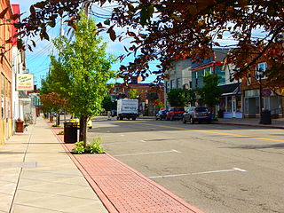
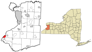
Ashford is a town in Cattaraugus County, New York, United States. The population was 1,974 at the 2020 census. The town is on the county's northern border.

<span class="mw-page-title-main">Angola, New York</span> Village in New York, United States

Angola is a village in the town of Evans in Erie County, New York, United States. Located 2 miles (3 km) east of Lake Erie, the village is 22 miles (35 km) southwest of downtown Buffalo. As of the 2010 Census, Angola had a population of 2,127. An unincorporated community known as Angola on the Lake, with a population of 1,675, lies between Angola village and Lake Erie.

<span class="mw-page-title-main">Angola on the Lake, New York</span> Census-designated place in New York, United States

Angola on the Lake is a hamlet and census-designated place (CDP) in Erie County, New York, United States. The population was 1,675 at the 2010 census. It is part of the Buffalo–Niagara Falls Metropolitan Statistical Area.

<span class="mw-page-title-main">Billington Heights, New York</span> Census-designated place in New York, United States

Billington Heights is a hamlet and census-designated place (CDP) in the towns of Elma and Aurora in Erie County, New York, United States. The population was 1,685 at the 2010 census. It is part of the Buffalo–Niagara Falls Metropolitan Statistical Area.

<span class="mw-page-title-main">Blasdell, New York</span> Village in New York, United States

Blasdell is a village in Erie County, New York, United States. The population was 2,553 according to the 2010 Census. The name is derived from Herman Blasdell, the first station master of the Erie and Pennsylvania railroad depot. It is part of the Buffalo–Niagara Falls Metropolitan Statistical Area.

<span class="mw-page-title-main">Elma Center, New York</span> Census-designated place in New York, United States

Elma Center is a hamlet and census-designated place (CDP) in the town of Elma in Erie County, New York, United States. As of the 2010 census, this community population was 2,571. It is part of the Buffalo–Niagara Falls Metropolitan Statistical Area.

<span class="mw-page-title-main">Harris Hill, New York</span> Hamlet in New York State

Harris Hill is a hamlet and census-designated place (CDP) located in the town of Clarence in Erie County, New York, United States. The population was 5,508 at the 2010 census. It is part of the Buffalo-Niagara Falls metropolitan area. The region is named after Asa Harris, a former officer in the American Colonial Army, who established a tavern near the top of a low hill northeast of Buffalo.

<span class="mw-page-title-main">Kenmore, New York</span> Village in New York, United States

Kenmore is a village in Erie County, New York, United States. The population was 15,205 at the 2020 census. It is part of the Buffalo-Niagara Falls metropolitan area.

<span class="mw-page-title-main">Lake Erie Beach, New York</span> Census-designated place in New York, United States

Lake Erie Beach is a hamlet and census-designated place (CDP) in the town of Evans, Erie County, New York, United States. The population was 3,872 at the 2010 census. It is part of the Buffalo–Niagara Falls Metropolitan Statistical Area.

<span class="mw-page-title-main">North Boston, New York</span> Census-designated place in New York, United States

North Boston is a hamlet and census-designated place (CDP) in the town of Boston in Erie County, New York, United States. As of the 2010 census, the CDP population was 2,521. It is part of the Buffalo–Niagara Falls Metropolitan Statistical Area.

<span class="mw-page-title-main">Sloan, New York</span> Village in New York, United States

Sloan is a village in Erie County, New York, United States. The population was 3,661 at the 2010 census. It is part of the Buffalo–Niagara Falls Metropolitan Statistical Area and is in the town of Cheektowaga.

<span class="mw-page-title-main">Rapids, New York</span> CDP in New York, United States

Rapids is a hamlet located in the Town of Lockport in Niagara County, New York, United States. The population was 1,636 at the 2010 census. The ZIP code for Rapids is 14094.

<span class="mw-page-title-main">North East, Pennsylvania</span> Borough in Pennsylvania, United States

North East is a borough in Erie County, Pennsylvania, United States, 14 miles (23 km) northeast of Erie. Located in the county's northeastern corner, the name comes from the geographical location. The population was 4,114 at the 2020 census, down from 4,294 in 2010. Fruit growing was an early economic endeavor, and is still to this day, as this is a popular area especially for cherries and grapes. There is an annual Cherry Festival in the summer and an annual Wine Country Harvest Festival in autumn. It is part of the Erie Metropolitan Statistical Area. It is the northernmost town in Pennsylvania.

<span class="mw-page-title-main">Northwest Harborcreek, Pennsylvania</span> Census-designated place in Pennsylvania, United States

Northwest Harborcreek is a census-designated place (CDP) in Erie County, Pennsylvania, United States. The population was 8,949 at the 2010 census. It includes the unincorporated communities of Fairfield and Brookside and is part of the Erie Metropolitan Statistical Area.

<span class="mw-page-title-main">Cheektowaga (CDP), New York</span> Census-designated place in New York, United States

Cheektowaga is a suburban community and census-designated place (CDP) in Erie County, New York, United States. The population was 75,178 at the 2010 census, making it the most populous census-designated place in New York. It is within the town of Cheektowaga. The CDP includes Buffalo Niagara International Airport.

<span class="mw-page-title-main">Eden (CDP), New York</span> Census-designated place in New York, United States

Eden is a hamlet and census-designated place (CDP) in Erie County, New York, United States. The population was 3,516 at the 2010 census. It is part of the Buffalo–Niagara Falls Metropolitan Statistical Area.

<span class="mw-page-title-main">Holland (CDP), New York</span> Census-designated place in New York, United States

Holland is a hamlet and census-designated place (CDP) in Erie County, New York, United States. The population was 1,206 at the 2010 census. It is in the town of Holland and is part of the Buffalo–Niagara Falls Metropolitan Statistical Area.

<span class="mw-page-title-main">Orchard Park (village), New York</span> Village in New York, United States

Orchard Park is a village in Erie County, New York, United States. The population was 3,246 at the 2010 census. The name is derived from a description of the local landscape, which abounded with orchards. It is part of the Buffalo–Niagara Falls Metropolitan Statistical Area.

<span class="mw-page-title-main">Addison (village), New York</span> Village in New York, United States

Addison is a village in Steuben County, New York, United States, in the southeast part of the town of the same name, and southwest of the city of Corning. The population was 1,763 at the 2010 census. The village and the surrounding town are named after the author Joseph Addison.

Wayland is a village in Steuben County, New York, United States. The population was 1,865 at the 2010 census.

References

  1. "ArcGIS REST Services Directory". United States Census Bureau. Retrieved September 20, 2022.
  2. "Town of Hamburg". Archived from the original on May 3, 2004. Retrieved January 15, 2007.
  3. "National Register of Historic Places Listings". Weekly List of Actions Taken on Properties: 12/10/12 through 12/14/12. National Park Service. December 21, 2012.
  4. "US Gazetteer files: 2010, 2000, and 1990". United States Census Bureau. February 12, 2011. Retrieved April 23, 2011.
  5. "Census of Population and Housing". Census.gov. Retrieved June 4, 2015.
  6. "U.S. Census website". United States Census Bureau . Retrieved January 31, 2008.