Tonawanda (CDP), New York

Last updated
Tonawanda, New York
Erie County New York incorporated and unincorporated areas Tonawanda (CDP) highlighted.svg
Location in Erie County and the state of New York
Coordinates: 42°59′7″N78°51′8″W / 42.98528°N 78.85222°W / 42.98528; -78.85222 Coordinates: 42°59′7″N78°51′8″W / 42.98528°N 78.85222°W / 42.98528; -78.85222
Country United States
State New York
County Erie
Town Tonawanda
Area
  Total18.6 sq mi (48.3 km2)
  Land17.3 sq mi (44.8 km2)
  Water1.4 sq mi (3.5 km2)
Elevation
574 ft (175 m)
Population
 (2010)
  Total58,144
  Density3,361/sq mi (1,297.7/km2)
Time zone UTC-5 (Eastern (EST))
  Summer (DST) UTC-4 (EDT)
Area code(s) 716
FIPS code 36-74183
GNIS feature ID0967652

Tonawanda is a census-designated place (CDP) in Erie County, New York, United States. The CDP comprises the town of Tonawanda minus its subsidiary village of Kenmore. [1] As of the 2010 census, the CDP population was 58,144. [2]

Contents

Geography

Tonawanda is located at 42°59′7″N78°51′7″W / 42.98528°N 78.85194°W / 42.98528; -78.85194 (42.985307, -78.852127). [3]

According to the United States Census Bureau, the CDP has a total area of 18.6 square miles (48.3 km2), of which 17.3 square miles (44.8 km2) is land and 1.4 square miles (3.5 km2), or 7.17%, is water. [2]

Demographics

Historical population
CensusPop.
1980 72,795
1990 65,284−10.3%
2000 61,729−5.4%
2010 58,144−5.8%
source: [4]

As of the census [5] of 2000, there were 61,729 people, 26,207 households, and 16,929 families living in the CDP. The population density was 3,554.2 per square mile (1,372.1/km2). There were 27,175 housing units at an average density of 1,564.7/sq mi (604.0/km2). The racial makeup of the CDP was 95.74% White, 1.52% Black or African American, 0.25% Native American, 1.30% Asian, 0.01% Pacific Islander, 0.36% from other races, and 0.82% from two or more races. Hispanic or Latino of any race were 1.30% of the population.

There were 26,207 households, out of which 26.3% had children under the age of 18 living with them, 51.2% were married couples living together, 10.3% had a female householder with no husband present, and 35.4% were non-families. 30.9% of all households were made up of individuals, and 15.3% had someone living alone who was 65 years of age or older. The average household size was 2.33 and the average family size was 2.93.

In the CDP, the population was spread out, with 21.5% under the age of 18, 7.2% from 18 to 24, 26.6% from 25 to 44, 22.7% from 45 to 64, and 22.1% who were 65 years of age or older. The median age was 42 years. For every 100 females, there were 88.4 males. For every 100 females age 18 and over, there were 84.4 males.

The median income for a household in the CDP was $41,332, and the median income for a family was $51,071. Males had a median income of $39,540 versus $27,067 for females. The per capita income for the CDP was $20,748. About 5.2% of families and 7.3% of the population were below the poverty line, including 9.7% of those under age 18 and 5.4% of those age 65 or over.

See also

Related Research Articles

Mojave Ranch Estates, Arizona CDP in Arizona, United States

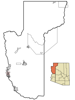
Mojave Ranch Estates is a census-designated place (CDP) in Mohave County, Arizona, United States. The population was 28 at the 2000 census.

Bayview-Montalvin, California former CDP in California, United States

Bayview-Montalvin is a former census-designated place (CDP) in Contra Costa County, California, United States. The population was 5,004 at the 2000 census.

Southeast Arcadia, Florida CDP in Florida, United States

Southeast Arcadia is a census-designated place (CDP) in DeSoto County, Florida, United States. The population was 6,554 at the 2010 census.

St. Peter, Illinois Village in Illinois, United States

St. Peter is a village in Fayette County, Illinois, United States. The population was 359 at the 2010 census.

Pistakee Highlands, Illinois Unincorporated in Illinois, United States

Pistakee Highlands is a census-designated place (CDP) in McHenry County, Illinois, United States. It consists primarily of an unincorporated area of McHenry County adjoining Pistakee Bay, within the McHenry post office, and is located just northeast of Johnsburg. The population was 3,454 at the 2010 census.

Supreme, Louisiana Census-designated place in Louisiana, United States

Supreme is a census-designated place (CDP) in Assumption Parish, Louisiana, United States. The population was 1,052 at the 2010 census.

Billington Heights, New York Census-designated place in New York, United States

Billington Heights is a hamlet and census-designated place (CDP) in the towns of Elma and Aurora in Erie County, New York, United States. The population was 1,685 at the 2010 census. It is part of the Buffalo–Niagara Falls Metropolitan Statistical Area.

Elma Center, New York Census-designated place in New York, United States

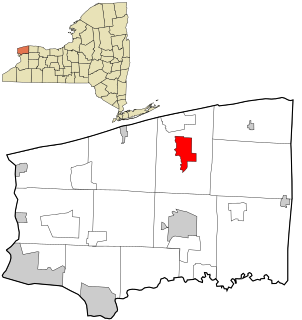
Elma Center is a hamlet and census-designated place (CDP) in the town of Elma in Erie County, New York, United States. As of the 2010 census, this community population was 2,571. It is part of the Buffalo–Niagara Falls Metropolitan Statistical Area.

North Boston, New York Census-designated place in New York, United States

North Boston is a hamlet and census-designated place (CDP) in the town of Boston in Erie County, New York, United States. As of the 2010 census, the CDP population was 2,521. It is part of the Buffalo–Niagara Falls Metropolitan Statistical Area.

Tribes Hill, New York CDP in New York, United States

Tribes Hill is a census-designated place (CDP) located in the Towns of Mohawk (80%) and Amsterdam (20%) in Montgomery County, New York, United States. The population was 1,003 at the 2010 census. One theory is the name is based on this location having been a gathering spot for the Mohawk nation, the dominant Iroquois tribe in the area during colonial times.

Rapids, New York CDP in New York, United States

Rapids is a hamlet located in the Town of Lockport in Niagara County, New York, United States. The population was 1,636 at the 2010 census. The ZIP code for Rapids is 14094.

Belmont, Pennsylvania Census-designated place in Pennsylvania, United States

Belmont is an unincorporated community and census-designated place (CDP) in Cambria County, Pennsylvania, United States. The population was 2,784 at the 2010 census.

Vinco, Pennsylvania Census-designated place in Pennsylvania, United States

Vinco is an unincorporated community and census-designated place (CDP) in Jackson Township, Cambria County, in the U.S. state of Pennsylvania. The population was 1,305 at the 2010 census.

Plymptonville, Pennsylvania Census-designated place in Pennsylvania, United States

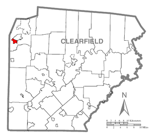
Plymptonville is a census-designated place (CDP) in Clearfield County, Pennsylvania, United States. The population was 981 at the 2010 census.

Sandy, Pennsylvania Census-designated place in Pennsylvania, United States

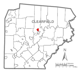
Sandy is a census-designated place (CDP) in Clearfield County, Pennsylvania, United States. The population was 1,429 at the 2010 census.

Lamont, Wisconsin Town in Wisconsin, United States

Lamont is a town in Lafayette County, Wisconsin, United States. The population was 267 at the 2000 census. The unincorporated community of Lamont is located in the town.

Yorkshire (CDP), New York Census-designated place in New York, United States

Yorkshire is a census-designated place (CDP) in the northeastern corner of the town of Yorkshire in Cattaraugus County, New York, United States. The population of the CDP was 1,180 at the 2010 census, out of 3,913 in the town of Yorkshire as a whole.

Eden (CDP), New York Census-designated place in New York, United States

Eden is a hamlet and census-designated place (CDP) in Erie County, New York, United States. The population was 3,516 at the 2010 census. It is part of the Buffalo–Niagara Falls Metropolitan Statistical Area.

Holland (CDP), New York Census-designated place in New York, United States

Holland is a hamlet and census-designated place (CDP) in Erie County, New York, United States. The population was 1,206 at the 2010 census. It is in the town of Holland and is part of the Buffalo–Niagara Falls Metropolitan Statistical Area.

Newfane (CDP), New York CDP in New York, United States

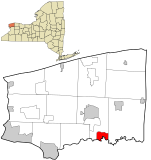
Newfane is a census-designated place (CDP) in the town of Newfane in Niagara County, New York, United States, along State Route 78. The population was 3,822 at the 2010 census. It is part of the Buffalo–Niagara Falls Metropolitan Statistical Area.

References

  1. "Archived copy" (PDF). Archived from the original (PDF) on 2006-09-23. Retrieved 2006-09-30.CS1 maint: archived copy as title (link)
  2. 1 2 "Geographic Identifiers: 2010 Demographic Profile Data (G001): Tonawanda CDP, New York". U.S. Census Bureau, American Factfinder. Retrieved February 19, 2016.[ dead link ]
  3. "US Gazetteer files: 2010, 2000, and 1990". United States Census Bureau. 2011-02-12. Retrieved 2011-04-23.
  4. "CENSUS OF POPULATION AND HOUSING (1790-2000)". U.S. Census Bureau . Retrieved 2010-07-17.
  5. "U.S. Census website". United States Census Bureau . Retrieved 2008-01-31.