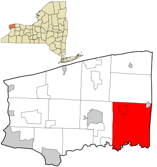
Wolcottsburg is a hamlet in the town of Clarence in Erie County, New York, United States. [1]
Contents

Wolcottsburg is a hamlet in the town of Clarence in Erie County, New York, United States. [1]
The settlement was originally known as West Prussia due to the large number of Prussian inhabitants. There is a German Lutheran church at the end of Wolcott Road that was constructed in 1873 and still stands today. [2]
Marvin's Bar & Grill is the sole remaining business in Wolcottsburg, [3] although there were once two stores and a hotel. [4]
A small stream, known as Black Creek, runs through the town and ends just after Goodrich Road. [5]
There is a small airstrip located in the western portion of the hamlet. [6]

Erie County is a county along the shore of Lake Erie in western New York State. As of the 2020 census, the population was 954,236. The county seat is Buffalo, which makes up about 28% of the county's population. Both the county and Lake Erie were named for the regional Iroquoian language-speaking Erie tribe of Native Americans, who lived in the area before 1654. They were later pushed out by the more powerful Iroquoian nations tribes.

Amherst is a town in Erie County, New York, United States. It is a suburb of Buffalo. As of 2020, the town had a total population of 129,595. This represents an increase from 122,366 as reported in the 2010 census.

Clarence is a town and affluent suburb located in the northeastern part of Erie County, New York, United States, northeast of Buffalo. The population was 32,950 according to the 2020 census estimate. This represents an increase of 7.4% from the 2010 census figure. The Clarence census-designated place occupies the southeast part of the town and roughly corresponds to a postal district with ZIP code 14031 and 14221 in the western side which it shares with nearby Williamsville. The town is named in honor of Prince William, Duke of Clarence and St Andrews (1765–1837), the third son of King George III and later king himself, as William IV.

Clarence Center is a affluent hamlet and census-designated place (CDP) in the town of Clarence in Erie County, New York, United States. The population was 2,257 at the 2010 census. It is part of the Buffalo–Niagara Falls Metropolitan Statistical Area.

Elma is a town in Erie County, New York, United States. The population was 11,721 at the 2020 census. The town is named after the American elm tree.

Darien is a town in Genesee County, New York, United States. The population was 3,158 at the 2010 census. Darien lies in the southwestern part of Genesee County, southwest of Batavia.

Pembroke is a town in Genesee County, Western New York, United States. The population was 4,292 at the 2010 census. The town is named for a town in west Wales. Pembroke lies on the west border of Genesee County, west of Batavia.
Royalton is a town in Niagara County, New York, United States. The population was 7,660 at the 2010 census.

Gaines is a town in Orleans County, New York, United States. The population was 3,378 at the 2010 census. The town is named after General Edmund P. Gaines, who defended the area during the War of 1812.

Ripley is a town on Lake Erie in the westernmost part of Chautauqua County, New York, United States. The population was 2,310 at the time of the 2020 census. The town was named after Eleazer Wheelock Ripley, a general in the War of 1812. There are no incorporated villages in the town, but there is one census-designated place: the hamlet of Ripley. The town is perhaps best known as being the western end of the New York State Thruway.

Lancaster is a town in Erie County, New York, United States, centered 14 miles east of downtown Buffalo. Lancaster is an outer ring suburb of Buffalo. As of the 2020 Census, the town population was 45,106.

Orchard Park is an incorporated town in Erie County, New York. It is an outer ring suburb southeast of Buffalo. As of the 2010 census, the population was 29,054, representing an increase of 5.13% from the 2000 census figure. The town contains a village also named Orchard Park. Orchard Park is one of the Southtowns of Erie County and is best known as the site of Highmark Stadium, home of the National Football League's Buffalo Bills.

East Amherst is a suburban hamlet 16 miles (26 km) northeast of downtown Buffalo, Erie County, New York, United States. It straddles the towns of Amherst and Clarence, and comprises the majority of ZIP code 14051. East Amherst also includes the headquarters of the fast food chain known as Mighty Taco.

New York State Route 78 (NY 78) is a 73.49-mile-long (118.27 km) state highway in western New York in the United States. While it is signed north–south, the southern portion runs in an east–west direction across Wyoming and Erie counties, from its beginning at a junction with NY 19 north of the village of Gainesville to the village of East Aurora. The part of the route north of East Aurora follows a generally north–south alignment to an intersection with NY 18 in the Niagara County town of Newfane, just south of the Lake Ontario shoreline. The route is most closely identified in the region with Transit Road, a major north–south trunk road through the center of Erie and Niagara counties; however, NY 78 does not follow Transit Road for its entire length, nor does Transit Road comprise more than half its length. The highway joins Transit Road north of East Aurora and stays with the road until nearly its end in the city of Lockport.
Derby is a hamlet in Erie County, New York, United States. It is the postal address for much of the town of Evans, within which Derby is fully contained. The Derby ZIP code is 14047, and includes the neighborhood of Highland-on-the-Lake. Derby is also home to the North Evans Fire District which includes Highland Hose Volunteer Fire Company and the North Evans Volunteer Fire Company. Derby is home to Highland Elementary School, part of the Lake Shore School District.
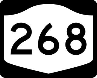
New York State Route 268 (NY 268) was a state highway in northeastern Erie County, New York, in the United States. It served as a connector between NY 5 in the town of Clarence and NY 78 at the Clarence–Amherst town line. The route passed through rural areas of the town of Clarence and did not serve any areas of significant development. The northern portion of NY 268 followed the southern bank of Tonawanda Creek.
Bowmansville is a hamlet located in the town of Lancaster in Erie County, New York, United States. It is named after Benjamin Bowman, the owner of sawmills on Ellicott Creek in the center of the hamlet.

New Oregon is a small hamlet in the town of North Collins in southern Erie County, New York, United States. The hamlet is on the South Branch Eighteen Mile Creek.

East Concord is a small hamlet in the town of Concord in southern Erie County, New York, United States. It is located at the intersection of NY Route 240 and Genesee Road.

Clarence is a hamlet and census-designated place (CDP) within the town of Clarence in Erie County, New York, United States. The population was 2,646 at the 2010 census.
42°03′29″N78°38′13″W / 42.05806°N 78.63694°W
| | This article about a location in Erie County, New York is a stub. You can help Wikipedia by expanding it. |
