Collins, New York

Last updated

Collins
Town of Collins
Erie County New York incorporated and unincorporated areas Collins highlighted.svg
Location in Erie County and the state of New York.
New York in United States (US48).svg
Location of New York in the United States
Coordinates: 42°29′47″N78°55′14″W / 42.49639°N 78.92056°W / 42.49639; -78.92056
CountryUnited States
State New York
County Erie
Incorporated1821
Government
  MayorDavid Tessmer
Area
[1]
  Total48.14 sq mi (124.68 km2)
  Land47.97 sq mi (124.23 km2)
  Water0.17 sq mi (0.45 km2)
Elevation
1,079 ft (329 m)
Population
 (2020)
  Total5,894 Decrease2.svg
  Density137.16/sq mi (52.96/km2)
Time zone UTC-5
  Summer (DST) UTC-4 (EDT)
ZIP code
14034
Area code 716
FIPS code 36-029-17200
Website www.townofcollins.com

Collins is a town in Erie County, New York, United States. The town is on the south border of the county and is considered to be one of the "Southtowns" of Erie County. The population at the 2010 census was 6,601. [2]

Contents

History

Dairy cows, Collins Center, New York, 1999 Dairy Cows, Collins Center, New York, 1999.jpg
Dairy cows, Collins Center, New York, 1999

The area was first settled by Whites in 1811. [3] Many of the first settlers were Quakers, [3] [4] who intended to assist the local Native Americans. [3] The town of Collins was formed March 6, 1821, from the town of Concord, and was named after the Collins family, a dairy farming family who lived in and were publicly active in the area. [5] The town lost land to create the new towns of Brant in 1839 and North Collins in 1852. Because of the concentration of dairy farms, there were once ten cheese and milk factories in the town.

Geography

According to the United States Census Bureau, the town has a total area of 48.1 square miles (124.7 km2), of which 48.0 square miles (124.2 km2) is land and 0.2 square miles (0.5 km2), or 0.36%, is water. [2]

The south town line of Collins, marked by Cattaraugus Creek, is the county line of Cattaraugus County.

U.S. Route 62 runs north–south through the town, and New York State Route 39 runs east–west and intersects with north–south New York State Route 75.

Demographics

Historical population
CensusPop.Note
1830 2,120
1840 4,257100.8%
1850 4,001−6.0%
1860 2,119−47.0%
1870 2,100−0.9%
1880 2,37112.9%
1890 2,362−0.4%
1900 2,87521.7%
1910 3,74230.2%
1920 4,0618.5%
1930 4,4248.9%
1940 5,81931.5%
1950 6,86217.9%
1960 6,9841.8%
1970 6,400−8.4%
1980 5,037−21.3%
1990 6,02019.5%
2000 8,30738.0%
2010 6,601−20.5%
2020 5,894−10.7%
U.S. Decennial Census [6]

As of the census [7] of 2000, there were 8,307 people, 1,754 households, and 1,187 families residing in the town. The population density was 172.6 inhabitants per square mile (66.6/km2). There were 1,884 housing units at an average density of 39.2 per square mile (15.1/km2). The racial makeup of the town was 66.85% White, 22.62% African American, 3.47% Native American, 0.22% Asian, 6.16% from other races, and 0.69% from two or more races. Hispanic or Latino of any race were 11.94% of the population.

There were 1,754 households, out of which 30.0% had children under the age of 18 living with them, 53.5% were married couples living together, 9.7% had a female householder with no husband present, and 32.3% were non-families. 26.7% of all households were made up of individuals, and 12.0% had someone living alone who was 65 years of age or older. The average household size was 2.50 and the average family size was 3.04.

In the town, the population was spread out, with 13.3% under the age of 18, 10.0% from 18 to 24, 48.6% from 25 to 44, 19.7% from 45 to 64, and 8.4% who were 65 years of age or older. The median age was 36 years. For every 100 females, there were 273.7 males. For every 100 females age 18 and over, there were 318.8 males.

The median income for a household in the town was $34,444, and the median income for a family was $45,647. Males had a median income of $30,215 versus $26,071 for females. The per capita income for the town was $14,082. About 6.2% of families and 8.5% of the population were below the poverty line, including 10.6% of those under age 18 and 8.1% of those age 65 or over.

Communities and Locations in the Town of Collins

Notable people

See also

Related Research Articles

<span class="mw-page-title-main">Erie County, New York</span> County in New York, United States

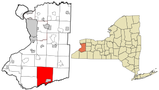
Erie County is a county along the shore of Lake Erie in western New York State. As of the 2020 census, the population was 954,236. The county seat is Buffalo, which makes up about 28% of the county's population. Both the county and Lake Erie were named for the regional Iroquoian language-speaking Erie tribe of Native Americans, who lived in the area before 1654. They were later pushed out by the more powerful Iroquoian nations tribes. The county is part of the Western New York region of the state.

Ashford is a town in Cattaraugus County, New York, United States. The population was 1,974 at the 2020 census. The town is on the county's northern border.

<span class="mw-page-title-main">Dayton, New York</span> Town in New York, United States

Dayton is a town in Cattaraugus County, New York, United States. The population was 1,689 at the 2020 census. The town is on the western border of Cattaraugus County.

<span class="mw-page-title-main">East Otto, New York</span> Town in New York, United States

East Otto is a town in Cattaraugus County, New York, United States. The population was 977 at the 2020 census. The town, along with neighboring Otto, is named after an agent of the Holland Land Company, Jacob Otto. The town of East Otto is on the northern border of the county.

<span class="mw-page-title-main">Machias, New York</span> Town in New York, United States

Machias is a town in Cattaraugus County, New York, United States. The population was 2,309 at the 2020 census. Machias is an interior town in the northeast quadrant of the county. It is northeast of the city of Salamanca.

Napoli is a town in Cattaraugus County, New York, United States. It is located in the western half of the county, northwest of Salamanca. The only permanent community in the town is Napoli village, formerly "Napoli Corners". The population was 1,173 at the 2020 census.

<span class="mw-page-title-main">New Albion, New York</span> Town in New York, United States

New Albion is a town in Cattaraugus County, New York, United States. The population was 1,990 at the 2020 census. The town is named after Albion in Orleans County, the source of some early settlers. New Albion is in the northwest quadrant of the county, northwest of the city of Salamanca.

<span class="mw-page-title-main">Otto, New York</span> Town in New York, United States

Otto is a town in Cattaraugus County, New York, United States. The population was 775 at the 2020 census. The name comes from Jacob S. Otto, an agent of the Holland Land Company. The town lies on the northern border of Cattaraugus County.

<span class="mw-page-title-main">Persia, New York</span> Town in New York, United States

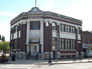
Persia is a town in Cattaraugus County, New York, United States. The population was 2,203 at the 2020 census. It is in the northwest part of the county. The village of Gowanda is partially in the town.

<span class="mw-page-title-main">Concord, New York</span> Town in New York, United States

Concord is a town in Erie County, New York, United States. The population was 8,494 at the 2010 census. The town is believed to be named after Concord, Massachusetts, by early settlers from New England.

<span class="mw-page-title-main">Sardinia, New York</span> Town in New York, United States

Sardinia is a town in Erie County, New York, United States. The town lies in the southeast corner of Erie County and is considered one of the county's "Southtowns". The town is southeast of Buffalo. The population was 2,775 at the 2010 census. The town is reportedly named after an old Christian hymn, Sardinia, and the homonymous Mediterranean island.

<span class="mw-page-title-main">Marcy, New York</span> Town in New York, United States

Marcy is a town in Oneida County, New York, United States. The population was 8,777 at the 2020 census. The town was named after Governor William L. Marcy. It lies between the cities of Rome and Utica. The Erie Canal passes through the southern part of the town.

<span class="mw-page-title-main">Gowanda, New York</span> Village in New York, United States

Gowanda is a village in western New York, United States. It lies partly in Erie County and partly in Cattaraugus County. The population was 2,512 at the 2020 census. The name is derived from a local Seneca language term meaning "almost surrounded by hills" or "a valley among the hills". The Erie County portion of Gowanda is part of the Buffalo–Niagara Falls metropolitan statistical area, while the Cattaraugus County portion is part of the Olean micropolitan statistical area.

Allegany is a town in Cattaraugus County, New York, United States. The population was 7,493 at the 2020 census.

Perrysburg is a hamlet, census-designated place, and former village in Cattaraugus County, New York, United States. The population was 401 at the 2010 census. It is named after Commodore Oliver Hazard Perry. The community is in the south-central part of the town of Perrysburg. The hamlet is west of Gowanda.

Perrysburg is a town in Cattaraugus County, New York, United States. The population was 1,515 at the 2020 census. The town is named after Commodore Oliver Hazard Perry and is located in the northwest corner of the county. The town contains the census-designated place also named Perrysburg, formerly an incorporated village.

<span class="mw-page-title-main">Yorkshire, New York</span> Town in New York, United States

Yorkshire is a town in Cattaraugus County, New York, United States. The population was 3,840 at the 2020 census. The town is located on the northern edge and in the northeast quadrant of the county.

<span class="mw-page-title-main">North Collins, New York</span> Town in New York, United States

North Collins is a town in Erie County, New York, United States. The population was 3,523 at the 2010 census. The name is derived from its parent town, Collins.

<span class="mw-page-title-main">Eden, New York</span> Town in New York, United States

Eden is a town located south of Buffalo, in Erie County, New York, the United States. The population was 7,688 at the 2010 census. The basis for choosing the town's name is unknown.

<span class="mw-page-title-main">Zoar, New York</span> Hamlet in New York, United States

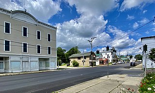
Zoar is a hamlet in the town of Collins in Erie County, New York, United States. Though it is in Collins, mail is postmarked to the Gowanda ZIP code of 14070. It is located on the northern side of Zoar Valley.

References

  1. "2016 U.S. Gazetteer Files". United States Census Bureau. Retrieved July 4, 2017.
  2. 1 2 "Geographic Identifiers: 2010 Demographic Profile Data (G001): Collins town, Erie County, New York". U.S. Census Bureau, American Factfinder. Retrieved February 29, 2016.[ dead link ]
  3. 1 2 3 4 Kirby, C.D. (1976). The Early History of Gowanda and the Beautiful Land of the Cattaraugus. Gowanda, NY: Niagara Frontier Publishing Company, Inc./Gowanda Area Bi-Centennial Committee, Inc.
  4. 1 2 3 Hosting innovative programming: Gowanda, Webcitation.org from the original at Geocities.com, November 1999, Retrieved March 18, 2014.
  5. 1 2 3 4 5 Historical sketch of the Village of Gowanda, N.Y. in commemoration of the fiftieth anniversary of its incorporation (August 8, 1898). Buffalo, NY: The Matthews-Northrup Company, Leonard, I.R., reprinted 1998, Salem, MA: Higginson Book Company
  6. "Census of Population and Housing". Census.gov. Retrieved June 4, 2015.
  7. "U.S. Census website". United States Census Bureau . Retrieved January 31, 2008.
  8. Gernatt Asphalt Products, Inc. Archived November 12, 2014, at the Wayback Machine , Collins, NY, 2001 | Accessdate= September 11, 2013
  9. Gernatt family of companies celebrate 50 years in materials industry Pit & Quarry, 98 (6), 10, 2005 | Accessdate= October 26, 2013
  10. An American success story of faith and exceptionalism, The Observer, Dunkirk, NY: John D'Agostino, January 31, 2010, Heischberger, R.L. | Accessdate= September 11, 2013