Newstead, New York

Last updated

Newstead
Town of Newstead
Erie County New York incorporated and unincorporated areas Newstead highlighted.svg
Location in Erie County and the state of New York.
New York in United States (US48).svg
Location of New York in the United States
Coordinates: 43°00′49″N78°30′54″W / 43.01361°N 78.51500°W / 43.01361; -78.51500
CountryUnited States
State New York
County Erie County
Incorporated1823
Named for Newstead Abbey, England
Government
  Town SupervisorDawn D. Izydorczak
  • John Jendrowski
  • Joe Dugan
  • Edmund Burke
  • Patricia Pope
Area
[1]
  Total51.05 sq mi (132.21 km2)
  Land50.76 sq mi (131.46 km2)
  Water0.29 sq mi (0.74 km2)
Elevation
659 ft (201 m)
Population
 (2020)
  Total8,689 Increase2.svg
  Density170.81/sq mi (65.95/km2)
Time zone UTC-5 (EST)
  Summer (DST) UTC-4 (EDT)
ZIP code
14001
Area code 716
FIPS code 36-029-50716
FIPS code 36-50716
GNIS feature ID0979273
Website www.erie.gov/newstead

Newstead is the northeasternmost town in Erie County, New York, United States. The population was 8,689 at the 2020 census. [2] The name is reportedly derived from Newstead Abbey in England.

Contents

Newstead is northeast of Buffalo, and its principal community is the village of Akron.

History

The town was first settled circa 1801.

The town of Newstead was established in 1823 as the "Town of Erie" from the eastern part of the town of Clarence. In 1831, the town's name was changed to "Newstead", reportedly on the advice of Abigail Fillmore, who was fond of the poetry of Lord Byron.

A fire in the 1870s destroyed town records, leaving little historical information about the town between 1823 and 1870.

The discovery of gypsum and the growth of the related cement industry helped promote the area.

Geography

According to the United States Census Bureau, the town has a total area of 51.05 square miles (132.21 km2), of which 50.76 square miles (131.46 km2) is land and 0.29 square miles (0.74 km2), or 0.56%, is water. [2]

Newstead is in the northeast corner of the county, and Tonawanda Creek defines the northern boundary.

Adjacent towns

The village of Akron lies within the town, east of the town's geographic center.

Major highways in the Town of Newstead

Demographics

Historical population
CensusPop.Note
1830 1,926
1840 2,65337.7%
1850 2,8999.3%
1860 3,1629.1%
1870 3,3806.9%
1880 3,5705.6%
1890 3,7214.2%
1900 3,8844.4%
1910 3,607−7.1%
1920 4,04312.1%
1930 4,3347.2%
1940 4,268−1.5%
1950 4,6539.0%
1960 5,82525.2%
1970 6,3228.5%
1980 7,23114.4%
1990 7,4402.9%
2000 8,40413.0%
2010 8,5942.3%
2020 8,6891.1%
U.S. Decennial Census [3]

As of the census [4] of 2000, there were 8,404 people, 3,371 households, and 2,332 families residing in the town. The population density was 164.9 inhabitants per square mile (63.7/km2). There were 3,623 housing units at an average density of 71.1 per square mile (27.5/km2). The racial makeup of the town was 98.20% White, 0.40% African American, 0.77% Native American, 0.12% Asian, 0.10% from other races, and 0.40% from two or more races. Hispanic or Latino of any race were 0.52% of the population.

There were 3,371 households, out of which 30.3% had children under the age of 18 living with them, 57.2% were married couples living together, 8.5% had a female householder with no husband present, and 30.8% were non-families. 26.1% of all households were made up of individuals, and 13.7% had someone living alone who was 65 years of age or older. The average household size was 2.49 and the average family size was 3.02.

In the town, the population was spread out, with 24.0% under the age of 18, 6.9% from 18 to 24, 28.5% from 25 to 44, 23.8% from 45 to 64, and 16.8% who were 65 years of age or older. The median age was 39 years. For every 100 females, there were 95.6 males. For every 100 females age 18 and over, there were 92.3 males.

The median income for a household in the town was $40,580, and the median income for a family was $50,255. Males had a median income of $34,306 versus $24,011 for females. The per capita income for the town was $18,447. About 2.9% of families and 4.2% of the population were below the poverty line, including 3.3% of those under age 18 and 6.1% of those age 65 or over.

Communities and locations in Newstead

Recreation

Newstead and the town of Clarence have constructed several miles of biking and jogging trails that link the towns on a former railroad right-of-way. The Octagon House in the village of Akron is open to visitors who wish to examine this architectural style.

Newstead, because of its vast expanses of open space, has become a popular place for golf course construction.

Notable people

Related Research Articles

<span class="mw-page-title-main">Erie County, New York</span> County in New York, United States

Erie County is a county along the shore of Lake Erie in western New York State. As of the 2020 census, the population was 954,236. The county seat is Buffalo, which makes up about 28% of the county's population. Both the county and Lake Erie were named for the regional Iroquoian language-speaking Erie tribe of Native Americans, who lived in the area before 1654. They were later pushed out by the more powerful Iroquoian nations tribes. The county is part of the Western New York region of the state.

<span class="mw-page-title-main">Genesee County, New York</span> County in New York, United States

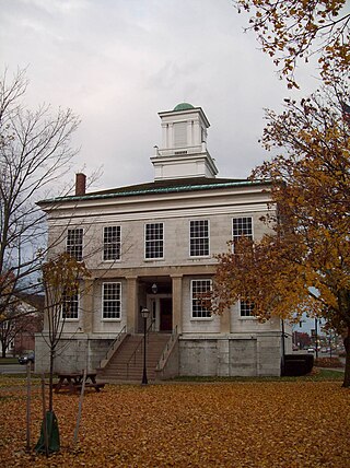
Genesee County is a county in the U.S. state of New York. As of the 2020 census, the population was 58,388. Its county seat is Batavia. Its name is from Seneca word Gen-nis'-hee-yo, meaning "the Beautiful Valley". The county was created in 1802 and organized in 1803. The county is part of the Finger Lakes region of the state.

<span class="mw-page-title-main">Akron, New York</span> Village in New York, United States

Akron is a village in Erie County, New York, United States. The population was 2,868 at the 2010 census. The name derives from the Greek word ἄκρον signifying a summit or high point. It is part of the Buffalo–Niagara Falls Metropolitan Statistical Area. Akron is located in the town of Newstead on the west and north slopes of a hill. NY 93 passes through the village.

<span class="mw-page-title-main">Clarence, New York</span> Town in New York, United States

Clarence is a town and affluent suburb located in the northeastern part of Erie County, New York, United States, northeast of Buffalo. The population was 32,950 according to the 2020 census estimate. This represents an increase of 7.4% from the 2010 census figure. The Clarence census-designated place occupies the southeast part of the town and roughly corresponds to a postal district with ZIP code 14031 and 14221 in the western side which it shares with nearby Williamsville. The town is named in honor of Prince William, Duke of Clarence and St Andrews (1765–1837), the third son of King George III and later king himself, as William IV.

<span class="mw-page-title-main">Concord, New York</span> Town in New York, United States

Concord is a town in Erie County, New York, United States. The population was 8,494 at the 2010 census. The town is believed to be named after Concord, Massachusetts, by early settlers from New England.

<span class="mw-page-title-main">Alabama, New York</span> Town in New York, United States

Alabama is a town in Genesee County, New York, United States. The town is in the northwestern part of the county. New York State Routes 63 and 77 intersect in the town. The population was 1,869 at the 2010 census. The town is named after the state of Alabama.

<span class="mw-page-title-main">Corfu, New York</span> Village in New York, United States

Corfu is a village in Genesee County, New York, United States. The population was 709 at the 2010 census. It is named after the Greek island of Corfu.

<span class="mw-page-title-main">Darien, New York</span> Town in Genesee County, New York

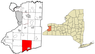
Darien is a town in Genesee County, New York, United States. The population was 3,010 at the 2020 census. Darien lies in the southwestern part of Genesee County, southwest of Batavia.

<span class="mw-page-title-main">Pembroke, New York</span> Town in New York, United States

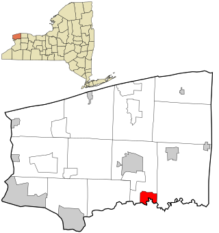
Pembroke is a town in Genesee County, Western New York, United States. The population was 4,292 at the 2010 census. The town is named after a town in west Wales. Pembroke lies on the west border of Genesee County, west of Batavia.

<span class="mw-page-title-main">Pendleton, New York</span> Town in New York, United States

Pendleton is a town on the southern edge of Niagara County, New York, United States. It is east of the city of Niagara Falls and southwest of the city of Lockport. The population was 6,397 at the 2010 census.

<span class="mw-page-title-main">Rapids, New York</span> CDP in New York, United States

Rapids is a hamlet located in the Town of Lockport in Niagara County, New York, United States. The population was 1,636 at the 2010 census. The ZIP code for Rapids is 14094.

<span class="mw-page-title-main">Royalton, New York</span> Town in New York, United States

Royalton is a town in Niagara County, New York, United States. The population was 7,660 at the 2010 census.

<span class="mw-page-title-main">Shelby, New York</span> Town in New York, United States

Shelby is a town in Orleans County, New York, United States. The population was 5,319 at the 2010 census.

<span class="mw-page-title-main">Attica, New York</span> Town in New York, United States

Attica is a town in Wyoming County, New York, United States. The population was 7,702 as of 2010.

<span class="mw-page-title-main">Tonawanda Reservation</span> Indian reservation in New York, United States

The Tonawanda Indian Reservation is an Indian reservation of the Tonawanda Seneca Nation located in western New York, United States. The band is a federally recognized tribe and, in the 2010 census, had 693 people living on the reservation. The reservation lies mostly in Genesee County, extending into Erie and Niagara counties. It is bordered by the Towns of Alabama, Pembroke, Newstead, and Royalton.

<span class="mw-page-title-main">Alden, New York</span> Town in New York, United States

Alden is a town in Erie County, New York, United States. The population was 10,865 at the 2010 census. The town is derived from a family name known to early settlers.

<span class="mw-page-title-main">Alexander (village), New York</span> Village in New York, United States

Alexander is a village in Genesee County, New York, United States. The population was 509 at the 2010 census. The village is named after early settler, Alexander Rea.

<span class="mw-page-title-main">Alexander, New York</span> Town in New York, United States

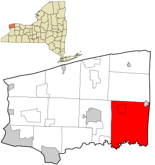
Alexander is a town in Genesee County, New York, United States. The population was 2,491 at the 2020 census. The town is named after Alexander Rea, an early settler, and is on the southern border of the county. It includes a village also named Alexander.

<span class="mw-page-title-main">Batavia (town), New York</span> Town in New York, United States

Batavia is a town in Genesee County, New York, United States. The population was 6,293 at the 2020 census. The name is derived from the Roman name for part of the Netherlands.

<span class="mw-page-title-main">Lockport (town), New York</span> Town in New York, United States

Lockport is a town in Niagara County, New York, United States. The population was 20,529 at the 2010 census. The name is derived from the series of canal locks on the Erie Canal. The locks lift boats from the lowland of Lake Ontario past the Niagara Escarpment.

References

  1. "2016 U.S. Gazetteer Files". United States Census Bureau. Retrieved July 4, 2017.
  2. 1 2 "Geographic Identifiers: 2010 Demographic Profile Data (G001): Newstead town, Erie County, New York". U.S. Census Bureau, American Factfinder. Retrieved March 2, 2016.[ dead link ]
  3. "Census of Population and Housing". Census.gov. Retrieved June 4, 2015.
  4. "U.S. Census website". United States Census Bureau . Retrieved January 31, 2008.