History of Westchester County

Last updated
1867 map of Westchester County Colton-westchester-map.jpg
1867 map of Westchester County

The history of Westchester County, a county in the state of New York, can be traced back to the founding of a settlement between the Hudson River and Long Island Sound in the 17th century. The area now known as Westchester County had seen human occupation since at least the Archaic period, but significant growth in the settlements that are now incorporated into the county did not occur until the Industrial Revolution.

Contents

Prehistory

At the time of European contact in the 16th and 17th centuries, the Native American inhabitants of present Westchester County were part of the Algonquian peoples, whose name for themselves was Lenape, meaning the people. They called the region Lenapehoking, which consisted of the area around and between the Delaware and Hudson Rivers. Two related languages, collectively known as the Delaware languages, were spoken throughout the region: Unami and Munsee. They were part of the larger Algonquian language family and related to Mahican. Munsee was spoken by the inhabitants of present-day Westchester County as well as on Manhattan Island. Some ethnographers, lacking valid contemporary sources, simply referred to the various tribes of the area as Munsee speakers, or, even more generally, as Lenni Lenape.

Title deeds given to European settlers supply considerable information on the sub-tribes in the region and their locations. The Manhattans occupied the island known by that name today, as well as the part of southern Westchester now covered by Yonkers. The Wecquaesgeek band of the Wappinger lived along the Hudson River and near the modern settlements of Dobbs Ferry, Tarrytown and White Plains. The Siwanoy lived along the coast of the Long Island Sound near present-day Pelham, New Rochelle, Larchmont, Mamaroneck and Rye. The northern portions of the county were occupied by smaller bands of Wappinger such as the Tankiteke, Kitchawank and Sintsink.

Colonial era

Van Cortlandt Manor Van-cortland-manor.jpg
Van Cortlandt Manor

The first European explorers to visit the Westchester area were Giovanni da Verrazzano in 1524 and Henry Hudson in 1609. European settlers were initially sponsored by the Dutch West India Company in the 1620s and 1630s, while English settlers arrived from New England in the 1640s. By 1664, the Dutch lost control of the area to the English and large tracts of Westchester were established as manors (held by a single owner) or patents (held by partners). The manor and patent owners leased land to tenant farmers and provided them with many essential services.

Westchester County was one of the original twelve counties of the Province of New York, created by an act of the New York General Assembly in 1683. At the time it also included present day Bronx County, which included the original Town of Westchester and portions of Yonkers, Eastchester, and Pelham.

Philipsburg Manor House PocanticoRiver3.jpg
Philipsburg Manor House

During the colonial period, life in Westchester was quite primitive. Roads were few and in poor condition, and transportation was heavily dependent on water. Nearly everything settlers consumed was raised or made on their farms. Wood, cattle and food were bartered for the items the settlers couldn't grow or make themselves. Over time cottage industries, such as shoe and furniture making, sprang up. This led to heavier use of local roads, which encouraged improvements, which in turn spurred increased travel. Taverns catering to travelers were established and ferries were launched. By 1775, Westchester was the richest and most populous county in the colony of New York.


American Revolutionary War

The county experienced a variety of effects, caused by the American Revolutionary War, as families were often divided between Patriot and Loyalist sympathies. After the battles of Pell's Point and White Plains in 1776, the primary American headquarters was located at Continental Village, north of Peekskill, while the British were headquartered in New York City. The region between Morrisania and the Croton River, which was called "neutral ground" was pillaged by both sides. [1] [2] Two loyalist factions, Skinner's Greens and De Lancey's Cowboys, engaged in guerrilla warfare, cattle theft, and looting. Warfare, settling scores against neighbors, and rape caused many residents to abandon their homes and flee the area. [3] The novel The Spy is set in the Neutral Ground.

The Philipsburg Manor House played an important role: British General Sir Henry Clinton used the manor house during the war. There in 1779 he wrote the Philipsburg Proclamation, which declared all Patriot-owned slaves to be free, and that blacks taken prisoner while serving in Patriot forces would be sold into slavery. [4]

Although the Revolutionary War devastated the county, recovery after the war was rapid. The large landowners in Westchester were mostly Loyalists, and after the war their lands were confiscated by the state and sold. Many local farmers were able to buy the lands they had previously farmed as tenants. In 1788, five years after the end of the war, the county was divided into 20 towns. In 1798, the first federal census recorded a population of 24,000 for the county.

19th century

In 1800, the first commercial toll road, the Westchester Turnpike, which ran through Pelham and New Rochelle, was chartered. Other toll roads, including the Croton (Somerstown) Turnpike, were later established. During this same period, steamboats began to be used on the Hudson River. The expansion of transportation options encouraged economic growth. Larger industries were established, such as iron foundries in Peekskill and Port Chester, brickyards in Verplank and Croton, and marble quarries in Ossining and Tuckahoe.

Two developments in the first half of the 19th century – the construction of the first Croton Dam and Aqueduct, and the coming of the railroad – had enormous impact on the growth of both Westchester and New York City. The Croton Dam and Aqueduct was begun in 1837 and completed in 1842. The aqueduct carried water 41 miles (66 km) from Croton to two reservoirs in Manhattan to be distributed to the city. Now a National Historic Landmark, the Croton Aqueduct is considered one of the great engineering achievements of the 19th century.

In the 1840s, the first railroads were built in Westchester. In 1844, the New York and Harlem Railroad reached White Plains. The Hudson River Railroad [nb 1] was completed to Peekskill in 1849, as was the New York and New Haven Railroad's route through eastern Westchester. The railroads often determined whether a town grew or declined, and they contributed to a population shift from Northern to Southern Westchester. By 1860, the total county population was 99,000, with the largest city being Yonkers. Many small downtowns, centered on railroad stations, flourished.

Civil War monument at Philipse Manor Hall in Getty Square, Yonkers Yonkers Civil War monument jeh.jpg
Civil War monument at Philipse Manor Hall in Getty Square, Yonkers

The period following the American Civil War enabled entrepreneurs in the New York area to create fortunes, and many built large estates in Westchester. Several mansions of this era are preserved and open to the public, including: Lyndhurst in Tarrytown, Kykuit in Pocantico Hills, the Jay Heritage Center in Rye, Caramoor in Katonah and Glenview in Yonkers.

Expansion of the New York City water supply system also impacted local development, as new dams, bridges and roads were built. The flooding of thousands of acres for reservoirs created considerable dislocations in many towns north of White Plains. The building of the New Croton Dam and its reservoir, for instance, resulted in the relocation of the hamlet of Katonah to higher ground. In North Salem, the hamlet of Purdys was moved when five percent of the town was inundated.

During the latter half of the 19th century, Westchester's transportation system and labor force attracted a manufacturing base, particularly along the Hudson River and Nepperhan Creek. Pills and patent medicines were manufactured in Ossining; greenhouses in Irvington; beer in Dobbs Ferry; sugar, paving materials and conduit in Hastings; and in Yonkers, elevators and carpets.

In 1874, the western portion of the present Bronx County, consisting of the towns of Kingsbridge, West Farms, and Morrisania, was transferred to the City & County of New York; and in 1895 the remainder of present-day Bronx County, consisting of the Town of Westchester (centered on the present-day Westchester Square) and portions of the towns of Eastchester and Pelham, was also transferred to the City & County of New York. Prior to that, a portion of the town of Eastchester had seceded, to become the city of Mount Vernon. In 1898, these annexed portions were formed into the Borough of the Bronx. In January 1914, The Bronx was split off from New York County and Bronx County was created, thus making the Borough of Manhattan & the County of New York coterminous with each other. [5]

20th century

During the 20th century, the rural character of Westchester would transform into the suburban county known today. Between the county's railroad network and the proliferation of the automobile in the early 20th century, working in New York City and living in the country became possible for the middle class. In 1907 the Bronx River Commission, a joint venture between New York City and Westchester County, was established to improve the river's water quality. The commission's efforts led to the creation of the Bronx River Parkway Reservation, completed in 1925, and the first modern, multi-lane limited-access roadway in North America. The success of the parkway encouraged the County government to develop its parks system, preserving great tracts of open space.

Playland in Rye, a National Historic Landmark, opened to the public in 1928, the first planned amusement park in the country, and is operated by Westchester County to this day. The development of Westchester's parks and parkway systems supported existing communities and encouraged the establishment of new ones, transforming the development pattern for Westchester. Homes were constructed on former estates and farms. New businesses appeared in response to expanded markets; White Plains, with branches of many New York City stores, became the county's central shopping district. With the need for homes expanding after World War II, multistory apartment houses appeared in the urbanized areas of the county, while the market for single-family houses continued to expand. By 1950, the total County population was 625,816.

Major interstate highways were constructed in Westchester during the 1950s and 1960s. The establishment of these roadways, along with the construction of the Tappan Zee Bridge, encouraged many major corporations, such as PepsiCo, General Foods, Ciba-Geigy and IBM to establish headquarters in Westchester.

21st century

See also

Notes

  1. The Hudson River Railroad later became part of the New York Central Railroad and is currently the Hudson Line of the Metro-North Railroad.

Related Research Articles

<span class="mw-page-title-main">Westchester County, New York</span> County in New York, United States

Westchester County is located in the U.S. state of New York. It is the seventh most populous county in the State of New York and the most populous north of New York City. According to the 2020 United States Census, the county had a population of 1,004,456, its highest decennial count ever and an increase of 55,344 (5.8%) from the 949,113 counted in 2010. Located in the Hudson Valley, Westchester covers an area of 450 square miles (1,200 km2), consisting of six cities, 19 towns, and 23 villages. Established in 1683, Westchester was named after the city of Chester, England. The county seat is the city of White Plains, while the most populous municipality in the county is the city of Yonkers, with 211,569 residents per the 2020 U.S. Census.

<span class="mw-page-title-main">Yonkers, New York</span> City in New York, United States

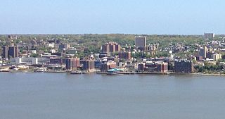
Yonkers is a city in Westchester County, New York, United States. The city, a core suburb of the New York Metropolitan Area had a population of 211,569 as of the 2020 United States Census. It is classified as an inner suburb of New York City, located directly to the north of the Bronx and approximately 2.4 miles (4 km) north of Marble Hill, the northernmost point in Manhattan.

Southern Westchester refers to the southern portion of Westchester County, New York, a dense inner-ring suburban area north of New York City.

<span class="mw-page-title-main">Pelham Islands</span> Archipelago in New York

The Pelham Islands are a group of islands in western Long Island Sound that belonged to Thomas Pell in the 17th century. The islands, and most of the surrounding area, were purchased from the Siwanoy Indians by Pell in 1654, creating Pelham Manor. This large tract of land would eventually become the present-day Town and Village of Pelham and Pelham Manor, Town of Eastchester, cities of New Rochelle and Mount Vernon in Westchester County, and the Pelham Bay and Eastchester neighborhoods of the Bronx in New York City.

The North Bronx is the northern section of the Bronx, one of the five boroughs of New York City. It is bordered by Westchester County to the north, the South Bronx to the south, the Hudson River to the west and the Long Island Sound to the east. The western part is more urbanized and hilly than its eastern counterpart, just like the rest of the borough. Despite being recognized as different from the South Bronx, the actual borders of the North Bronx is undefined. One commonly set border is Fordham Road/Pelham Parkway, the upper limit for widespread poverty and arson during the 1970s and 1980s.

<span class="mw-page-title-main">Getty Square</span> Public square in Yonkers, New York

Getty Square is the name for downtown Yonkers, New York, centered on the public square. Getty Square is the civic center, central business district, and transit hub of the City of Yonkers. A dense and growing residential area, it is located in southern Westchester County, New York. The square is named after prominent 19th-century merchant Robert Getty.

<span class="mw-page-title-main">Croton Aqueduct</span> Pipeline that carried water to New York City from its reservoirs in 19th century

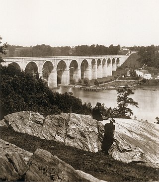
The Croton Aqueduct or Old Croton Aqueduct was a large and complex water distribution system constructed for New York City between 1837 and 1842. The great aqueducts, which were among the first in the United States, carried water by gravity 41 miles (66 km) from the Croton River in Westchester County to reservoirs in Manhattan. It was built because local water resources had become polluted and inadequate for the growing population of the city. Although the aqueduct was largely superseded by the New Croton Aqueduct, which was built in 1890, the Old Croton Aqueduct remained in service until 1955.

<span class="mw-page-title-main">Hudson Line (Metro-North)</span> Metro-North Railroad line in New York

The Hudson Line is a commuter rail line owned and operated by the Metro-North Railroad in the U.S. state of New York. It runs north from New York City along the east shore of the Hudson River, terminating at Poughkeepsie. The line was originally the Hudson River Railroad, and eventually became the Hudson Division of the New York Central Railroad. It runs along what was the far southern leg of the Central's famed "Water Level Route" to Chicago.

<span class="mw-page-title-main">New York State Route 9A</span> Highway in New York

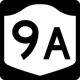
New York State Route 9A (NY 9A) is a state highway in the vicinity of New York City in the United States. Its southern terminus is at Battery Place near the northern end of the Brooklyn–Battery Tunnel in New York City, where it intersects with both the unsigned Interstate 478 (I-478) and FDR Drive. The northern terminus of NY 9A is at U.S. Route 9 (US 9) in Peekskill. It is predominantly an alternate route of US 9 between New York City and Peekskill; however, in New York City, it is a major route of its own as it runs along the West Side Highway and Henry Hudson Parkway. It is also one of only two signed New York State routes in Manhattan. In northern Westchester County, NY 9A follows the Briarcliff–Peekskill Parkway.

<span class="mw-page-title-main">New York State Route 100</span> State highway in Westchester New York, US

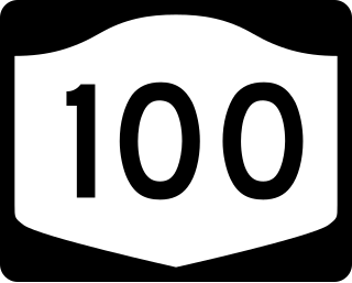
New York State Route 100 (NY 100) is a major north–south state highway in Westchester County, New York, in the United States. It begins parallel to Interstate 87 (I-87) at a junction with the Cross County Parkway in the city of Yonkers and runs through most of the length of the county up to U.S. Route 202 (US 202) in the town of Somers. NY 100 was designated as part of the 1930 renumbering of state highways in New York. Prior to becoming a state road, various sections of NY 100 were part of several important early roads in the county.

<span class="mw-page-title-main">Saw Mill River</span> River in the United States of America

The Saw Mill River is a 23.5-mile (37.8 km) tributary of the Hudson River in Westchester County, New York, United States. It flows from an unnamed pond north of Chappaqua to Getty Square in Yonkers, where it empties into the Hudson as that river's southernmost tributary. It is the only major stream in southern Westchester County to drain into the Hudson instead of Long Island Sound. It drains an area of 26.5 square miles (69 km2), most of it heavily developed suburbia. For 16 miles (26 km), it flows parallel to the Saw Mill River Parkway, a commuter artery, an association that has been said to give the river an "identity crisis."

<span class="mw-page-title-main">Westchester–Putnam Council</span> Boy Scouts of America local council

Westchester–Putnam Council was a local council of the Boy Scouts of America, serving Boy Scouts in southeastern New York State. It merged with the Hudson Valley Council in January 2021 to become the Greater Hudson Valley Council.

<span class="mw-page-title-main">Third Avenue Railway</span> Streetcar system in southern New York (1852–1952)

The Third Avenue Railway System (TARS), founded 1852, was a streetcar system serving the New York City boroughs of Manhattan and the Bronx along with lower Westchester County. For a brief period of time, TARS also operated the Steinway Lines in Long Island City.

There are forty-five local police agencies in Westchester County, New York. As well as other agencies. They are responsible for protecting Westchester County, these agencies frequently work with one another in the surrounding counties. Current economic times has caused a few Westchester municipalities to consider consolidation of police services. The Westchester County Department of Public Safety started providing primary police services for the Town/Village of Mount Kisco in 2015.

Westchester County, New York, in the United States, contains 40 public school districts, 118 private schools and 14 colleges/universities. According to the 2018 rankings provided by the education website Niche, taking into account public comments, 28 of the top 100 school districts in New York State were located in Westchester County.

<span class="mw-page-title-main">National Register of Historic Places listings in northern Westchester County, New York</span>

This is a list of the National Register of Historic Places listings in northern Westchester County, New York, excluding the city of Peekskill, which has its own list.

<span class="mw-page-title-main">National Register of Historic Places listings in southern Westchester County, New York</span>

This is a list of the National Register of Historic Places listings in southern Westchester County, New York, excluding the cities of New Rochelle and Yonkers, which have separate lists of their own.

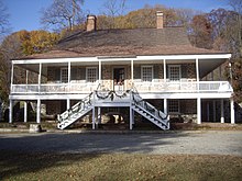
There are numerous nationally and locally designated historic sites and attractions in Westchester County. These include architecturally significant manors and estates, churches, cemeteries, farmhouses, African-American heritage sites, and underground railroad depots and waystations. There are sites from pre-Revolutionary and Revolutionary times, as well as battlegrounds. Westchester County also played an important role in the development of the modern suburb, and there are many associated heritage sites and museums.

References

  1. Burrows, Edwin G. and Wallace, Mike (1999). Gotham: A History of New York City to 1898 . New York: Oxford University Press. ISBN   0-195-11634-8.
  2. Osborn, David (2014). "The Revolutionary War 'neutral ground' of Westchester County" (PDF). St. Paul's National Historic Site, NPS[ dead link ].
  3. The Fate Of The American Revolution
  4. Kelley, Robin; Lewis, Earl (2005). To Make Our World Anew: Volume I: A History of African Americans to 1880. New York: Oxford University Press. p. 120. ISBN   978-0-19-518135-7.
  5. On the start of business for Bronx County: Bronx County In Motion. New Officials All Find Work to Do on Their First Day. The New York Times , January 3, 1914 (PDF retrieved on January 30, 2011)

Further reading

41°09′N73°51′W / 41.15°N 73.85°W / 41.15; -73.85