Lansdowne-Baltimore Highlands, Maryland

Last updated
Lansdowne-Baltimore Highlands, Maryland
Baltimore County Maryland Incorporated and Unincorporated areas Lansdowne-Baltimore Highlands Highlighted.svg
Location of Lansdowne-Baltimore Highlands, Maryland
Coordinates: 39°14′20″N76°39′4″W / 39.23889°N 76.65111°W / 39.23889; -76.65111 Coordinates: 39°14′20″N76°39′4″W / 39.23889°N 76.65111°W / 39.23889; -76.65111
CountryFlag of the United States.svg United States
State Flag of Maryland.svg  Maryland
County Flag of Baltimore County, Maryland.svg Baltimore
Area
  Total4.3 sq mi (11.1 km2)
  Land4.1 sq mi (10.6 km2)
  Water0.2 sq mi (0.5 km2)
Population
 (2000)
  Total15,724
  Density3,836.8/sq mi (1,481.4/km2)
Time zone UTC−5 (Eastern (EST))
  Summer (DST) UTC−4 (EDT)
ZIP code
21227
Area code 410 and 443
FIPS code 24-45662

Lansdowne-Baltimore Highlands was a census-designated place (CDP) in Baltimore County, Maryland, United States. The population was 15,724 at the 2000 census. At the 2010 census the area was split into two separate CDPs, the unincorporated communities of Lansdowne and Baltimore Highlands.

Contents

Geography

Lansdowne-Baltimore Highlands was located at 39°14′20″N76°39′4″W / 39.23889°N 76.65111°W / 39.23889; -76.65111 (39.238782, 76.651246). [1]

According to the United States Census Bureau, the CDP had a total area of 4.3 square miles (11 km2), of which, 4.1 square miles (11 km2) of it is land and 0.2 square miles (0.52 km2) of it (4.21%) is water.

Demographics

As of the census [2] of 2000, there were 15,724 people, 5,796 households, and 4,190 families residing in the CDP. The population density was 3,836.8 inhabitants per square mile (1,481.4/km2). There were 6,041 housing units at an average density of 1,474.1 per square mile (569.2/km2). The racial makeup of the CDP was 75.70% White, 18.37% African American, 0.36% Native American, 1.86% Asian, 0.03% Pacific Islander, 1.74% from other races, and 1.95% from two or more races. Hispanic or Latino of any race were 3.54% of the population.

There were 5,796 households, out of which 39.1% had children under the age of 18 living with them, 42.0% were married couples living together, 24.1% had a female householder with no husband present, and 27.7% were non-families. 21.8% of all households were made up of individuals, and 7.7% had someone living alone who was 65 years of age or older. The average household size was 2.71 and the average family size was 3.11.

In the CDP, the population was spread out, with 29.6% under the age of 18, 10.6% from 18 to 24, 30.4% from 25 to 44, 19.2% from 45 to 64, and 10.3% who were 65 years of age or older. The median age was 32 years. For every 100 females, there were 89.5 males. For every 100 females age 18 and over, there were 83.9 males.

The median income for a household in the CDP was $37,160, and the median income for a family was $41,559. Males had a median income of $33,244 versus $22,906 for females. The per capita income for the CDP was $16,348. About 12.7% of families and 13.8% of the population were below the poverty line, including 20.6% of those under age 18 and 6.7% of those age 65 or over.

Related Research Articles

<span class="mw-page-title-main">Brooklyn Park, Maryland</span> Census-designated place in Maryland, United States

Brooklyn Park is a census-designated place (CDP) in Anne Arundel County, Maryland, United States. The population was 14,373 at the 2010 census.

<span class="mw-page-title-main">Ferndale, Maryland</span> Census-designated place in Maryland, United States

Ferndale is a census-designated place (CDP) in Anne Arundel County, Maryland, United States. At the 2010 census, the population was 16,746.

<span class="mw-page-title-main">Linthicum, Maryland</span> Census-designated place in Maryland, United States

Linthicum is a census-designated place (CDP) and unincorporated community in Anne Arundel County, Maryland, United States. The population was 10,324 at the 2010 census. It is located directly north of Baltimore–Washington International Thurgood Marshall Airport (BWI).

<span class="mw-page-title-main">Pumphrey, Maryland</span> Unincorporated community in Maryland, United States

Pumphrey is an unincorporated community and former census-designated place (CDP) in Anne Arundel County, Maryland, United States. At the 2000 census, the population was 5,317. It was split between the Linthicum and Brooklyn Park CDPs for the 2010 census.

<span class="mw-page-title-main">Bowleys Quarters, Maryland</span> Census-designated place in Maryland, United States

Bowleys Quarters is an unincorporated community and census-designated place in Baltimore County, Maryland, United States, with a population of 6,755 at the 2010 census.

<span class="mw-page-title-main">Carney, Maryland</span> Census-designated place in Maryland, United States

Carney is an unincorporated community and census-designated place in Baltimore County, Maryland, United States. The population was 29,941 at the 2010 census.

<span class="mw-page-title-main">Edgemere, Maryland</span> Census-designated place in Maryland, United States

Edgemere is an unincorporated community and census-designated place in Baltimore County, Maryland, United States. The population was 8,669 at the 2010 census. Founded in 1899 as Edgemere being renamed from previous name "Fitzell". Meeting held at the Fitzell Farm which was situated where the old Rheem plant was located.

<span class="mw-page-title-main">Lochearn, Maryland</span> Census-designated place in Maryland, United States

Lochearn is an unincorporated community and census-designated place in Baltimore County, Maryland, United States, located immediately to the west of the City of Baltimore. Per the 2020 census, the population was 25,511.

<span class="mw-page-title-main">Rosedale, Maryland</span> Census-designated place in Maryland, United States

Rosedale is an unincorporated community and census-designated place in Baltimore County, Maryland, United States. The population was 19,257 at the 2010 United States Census.

<span class="mw-page-title-main">Rossville, Maryland</span> Census-designated place in Maryland, United States

Rossville is an unincorporated community and census-designated place in Baltimore County, Maryland, United States. The population was 15,147 at the 2010 census.

<span class="mw-page-title-main">Bel Air North, Maryland</span> Census-designated place in Maryland, United States

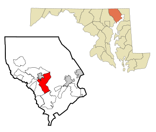
Bel Air North is a census-designated place (CDP) in Harford County, Maryland, United States. It is situated immediately north of the incorporated town of Bel Air. As of the 2010 census, the CDP population was 30,568, up from 25,798 in 2000.

<span class="mw-page-title-main">Bel Air South, Maryland</span> Census-designated place in Maryland, United States

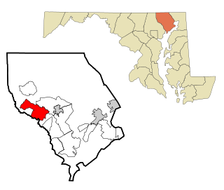
Bel Air South is a census-designated place (CDP) in Harford County, Maryland, United States. The population was 47,709 at the 2010 census, up from 39,711 in 2000.

<span class="mw-page-title-main">Fallston, Maryland</span> Census-designated place in Maryland, United States

Fallston is a census-designated place (CDP) in Harford County, Maryland, United States. The population was 8,958 at the 2010 census, up from 8,427 in 2000. Fallston is a semi-rural community consisting mostly of farms and suburban-like developments.

<span class="mw-page-title-main">Pleasant Hills, Maryland</span> Census-designated place in Maryland, United States

Pleasant Hills is a census-designated place (CDP) in Harford County, Maryland, United States. The population was 3,379 at the 2010 census, up from 2,851 in 2000. There is no post office with the designation "Pleasant Hills"; most of the residents have either Fallston or Kingsville addresses and consider themselves as belonging to those communities.

<span class="mw-page-title-main">Vado, New Mexico</span> Place and community in the United States

Vado is an unincorporated community and census-designated place (CDP) in Doña Ana County, New Mexico, United States. The population was 3,194 at the 2010 census. The ZIP code for Vado is 88072, its area code is 575, and it is part of the Las Cruces Metropolitan Statistical Area.

<span class="mw-page-title-main">Lake Heritage, Pennsylvania</span> Census-designated place in Pennsylvania, United States

Lake Heritage is a census-designated place (CDP) in Adams County, Pennsylvania, United States. Its population was 2,158 at the 2020 census.

North Shore is a census-designated place (CDP) in Franklin County, Virginia, United States. The population was 3,094 at the 2010 census, up from 2,112 in 2000. It is part of the Roanoke Metropolitan Statistical Area.

<span class="mw-page-title-main">Tracyton, Washington</span> Census-designated place in Washington, United States

Tracyton is a census-designated place (CDP) in Kitsap County, Washington, United States. Its population was 5,233 at the 2010 census. It was named for 19th century Secretary of the Navy Benjamin F. Tracy.

<span class="mw-page-title-main">Lansdowne, Maryland</span> Census-designated place in Maryland, United States

Lansdowne is a census-designated place in southern Baltimore County, Maryland, United States, located just south of Baltimore city. As of the 2010 census, it had a population of 8,409. At the 2000 census and earlier, the area was delineated as part of the Lansdowne-Baltimore Highlands CDP.

<span class="mw-page-title-main">Baltimore Highlands, Maryland</span> Census-designated place in Maryland, United States

Baltimore Highlands is a census-designated place (CDP) in Baltimore County, Maryland, United States, directly south of the city of Baltimore. The population was 7,019 at the 2010 census. At the 2000 census and earlier, the area was delineated as part of the Lansdowne-Baltimore Highlands CDP.

References

  1. "US Gazetteer files: 2010, 2000, and 1990". United States Census Bureau. 2011-02-12. Retrieved 2011-04-23.
  2. "U.S. Census website". United States Census Bureau . Retrieved 2008-01-31.