
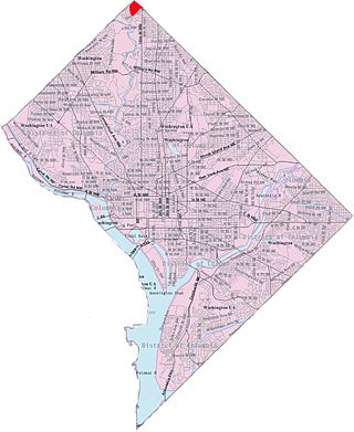
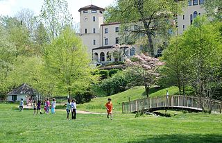
Rock Creek Gardens is an affluent residential neighborhood in Northwest, Washington, D.C.
It is bounded by West Beach Drive to the east and northeast, Parkside Drive to the south and southwest, and Rock Creek Park to the northeast.
Rock Creek Gardens is an affluent residential neighborhood in Northwest, Washington, D.C.
It is bounded by West Beach Drive to the east and northeast, Parkside Drive to the south and southwest, and Rock Creek Park to the northeast.
West Beach and Parkside also abut the park, making Rock Creek Gardens the only neighborhood in the city to be surrounded entirely by Rock Creek Park, hence its name. It is not set on or adjacent to any major thoroughfare in the city: the only access to the neighborhood is by taking Portal or North Portal Drive via the rotary intersection on 16th Street NW; turning south on East Beach Drive; west on a short strip joining East and West Beach Drives; then turning either direction on West Beach.
Because of its isolation via the park and lack of major streets, the neighborhood is extraordinarily suburban in character, full of winding streets, detached houses on large lots, and open space.
Rock Creek Gardens and the rest of Ward 4 are represented in the Council of the District of Columbia by Brandon Todd.
Rock Creek Gardens is also the name of two condominium complexes, one immediately adjacent to the neighborhood but in Maryland, which also borders the park (on Washington Avenue and Grubb Road), and another in Georgetown (on Q Street NW).
38°59′19″N77°02′44″W / 38.9887°N 77.0455°W
| | This article about a location in Washington, D.C., is a stub. You can help Wikipedia by expanding it. |

Northeast is the northeastern quadrant of Washington, D.C., the capital of the United States. It encompasses the area located north of East Capitol Street and east of North Capitol Street.

Swampoodle was a neighborhood in Washington, D.C. on the border of Northwest and Northeast in the second half of 19th and early 20th century. This neighborhood is no longer known as Swampoodle and has been replaced in large part by NoMa.

Shepherd Park is a neighborhood in the northwest quadrant of Washington, D.C. In the years following World War II, restrictive covenants which had prevented Jews and African Americans from purchasing homes in the neighborhood were no longer enforced, and the neighborhood became largely Jewish and African American. Over the past 40 years, the Jewish population of the neighborhood has declined but the neighborhood has continued to support a thriving upper and middle class African American community. The Shepherd Park Citizens Association and Neighbors Inc. led efforts to stem white flight from the neighborhood in the 1960s and 1970s, and it has remained a continuously integrated neighborhood, with very active and inclusive civic groups.
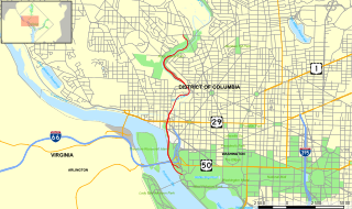
The Rock Creek and Potomac Parkway, informally called the Rock Creek Parkway, is a parkway maintained by the National Park Service as part of Rock Creek Park in Washington, D.C. It runs next to the Potomac River and Rock Creek in a generally north–south direction, carrying four lanes of traffic from the Lincoln Memorial and Arlington Memorial Bridge north to a junction with Beach Drive near Connecticut Avenue at Calvert Street, N.W., just south of the National Zoological Park.

Constitution Avenue is a major east–west street in the northwest and northeast quadrants of the city of Washington, D.C., in the United States. It was originally known as B Street, and its western section was greatly lengthened and widened between 1925 and 1933. It received its current name on February 26, 1931, though it was almost named Jefferson Avenue in honor of Thomas Jefferson.
Virginia Avenue is a street in the Northwest, Southwest, and Southeast quadrants of Washington, D.C. Like other state-named streets in Washington, it diagonally crosses the grid pattern formed by lettered (east-west) and numbered (north-south) streets.

Petworth is a neighborhood of Washington, D.C., located in Northwest D.C. While largely residential, Petworth is home to a notable commercial corridor of shops and restaurants, primarily along Georgia Avenue and Upshur Street, as well as a portion of 14th Street. The neighborhood is accessible via the Georgia Ave–Petworth station on the Green Line of the Washington Metro.

The name "M Street" refers to two major roads in the United States capital of Washington, D.C. Because of the Cartesian coordinate system used to name streets in Washington, the name "M Street" can be used to refer to any east-west street located twelve blocks north or south of the dome of the United States Capitol. Thus, in all four quadrants of the city there are streets called "M Street", which are disambiguated by quadrant designations, namely, M Street NW, NE, SW, and SE.
The Inner Loop was two planned freeways around downtown Washington, D.C. The innermost loop would have formed an oval centered on the White House, with a central freeway connecting the southern segment to the northern segment and then continuing on to Interstate 95. Interstate 95 would have met Interstate 66, Interstate 295, Interstate 695, and US 50 while traversing the Inner Loop. A second loop was an arc across the northern section of the city, beginning at East Capitol Street at the Anacostia River and using the Missouri Avenue NW and Nebraska Avenue NW commercial corridors to terminate in Georgetown.

New Hampshire Avenue is a diagonal avenue in Washington, D.C., beginning at the Kennedy Center and extending northeast for about 5 miles (8 km) and then continuing into Maryland, where it is designated Maryland Route 650. New Hampshire Avenue is not contiguous. It stops at 15th and W Streets NW, and resumes again on the other side of Columbia Heights at Park Road NW, a few blocks from Georgia Avenue.

Kenilworth is a residential neighborhood in Northeast Washington, D.C., located on the eastern bank of the Anacostia River and just inside the D.C.-Maryland border. A large public housing complex, Kenilworth Courts, dominates the area. The neighborhood is famous for the Kenilworth Park and Aquatic Gardens, a national park whose centerpiece is a series of ponds carved out of Anacostia River marshland. Visitors come especially during June and July to see the beautiful blooming water lilies and lotus flowers. In 1895 the name “Kenilworth” was first applied to the area by white real estate developer Allen Mallery, who named this neighborhood after Kenilworth Castle in England, the ruins of which can still be seen today in Warwickshire. Kenilworth Park, which includes the Kenilworth-Parkside Recreation Center, also carries the neighborhood name, though most of the park's area is actually located adjacent to the modern neighborhoods of Parkside and Eastland Gardens.
Manor Park is a neighborhood in Ward 4 of northwest Washington, D.C.
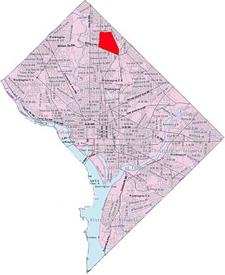
North Portal Estates is an affluent residential neighborhood in Washington, D.C. that forms the northernmost corner of the District of Columbia. North Portal Estates is bounded by North Portal Drive to the south, East Beach Drive to the west and northwest, and Rock Creek Park to the northeast. It is not set on any major thoroughfare in the city, although North Portal Drive is accessible via a rotary intersection on 16th Street NW.

Downtown is the central business district of Washington, D.C., located in Northwest D.C. It is the third largest central business district in the United States. The "Traditional Downtown" has been defined as an area roughly between Union Station in the east and 16th Street NW in the west, and between the National Mall on the south and Massachusetts Avenue on the north, including Penn Quarter. However, nowadays, Downtown D.C. usually refers to a larger area, as the DC Office of Planning states:
…most residents, workers, and visitors think of Downtown in a broader sense — including areas as far north as Dupont Circle, as far west as Foggy Bottom, and as far east as Capitol Hill. Only about half of the central city workforce is located within the city’s traditional Downtown.

Sixteenth Street Heights is a large neighborhood of rowhouses, duplexes, and American Craftsman and American Foursquare detached houses in Northwest Washington, D.C.

The boundary markers of the original District of Columbia are the 40 milestones that marked the four lines forming the boundaries between the states of Maryland and Virginia and the square of 100 square miles (259 km2) of federal territory that became the District of Columbia in 1801. Working under the supervision of three commissioners that President George Washington had appointed in 1790 in accordance with the federal Residence Act, a surveying team led by Major Andrew Ellicott placed these markers in 1791 and 1792. Among Ellicott's assistants were his brothers Joseph and Benjamin Ellicott, Isaac Roberdeau, George Fenwick, Isaac Briggs and an African American astronomer, Benjamin Banneker.
Lowell School is an independent, diverse, co-educational preschool through 8th grade school located in the Colonial Village neighborhood near Shepherd Park Washington, D.C. The school was founded by Judith Grant and Susan Semple in 1965 during the Civil Rights Movement on the educational philosophies of Haim Ginott, Jean Piaget, Maria Montessori, John Dewey, and Friedrich Fröbel.
Rock Creek Park Golf Course is a golf course located in Washington, D.C., in the United States. The entire course lies within Rock Creek Park, a national park owned and maintained by the National Park Service division of the United States Department of the Interior.
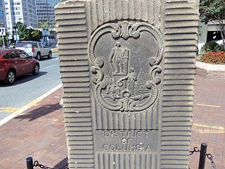
The Garden Club of America Entrance Markers in Washington, D.C., are carven stone pylons installed along the border of the District of Columbia in 1932 and 1933 by local Garden Club of America chapters. Originally about five feet tall, the markers were placed at important entrance points to the national capital. Seven survive: sets of two markers in Westmoreland Circle, Friendship Heights, and Chevy Chase Circle; and a single marker along Georgia Avenue. These surviving markers are listed on the National Register of Historic Places.

Western Avenue is one of three boundary streets between Washington, D.C., and the state of Maryland. It follows a southwest-to-northeast line, beginning at Westmoreland Circle in the south and ending at Oregon Avenue NW in the north. It is roughly 3.5 miles (5.6 km) in length. First proposed in 1893, it was constructed somewhat fitfully from about 1900 to 1931.