
Adams Morgan is a neighborhood in Washington, D.C., located in Northwest D.C., centered on the intersection of 18th Street NW and Columbia Road. The Washington Hilton and Madam's Organ Blues Bar are in Adams Morgan. Residential buildings include Euclid Apartments, Fuller House, Park Tower, Meridian Mansions, and the Pink Palace. Embassies in the neighborhood include the embassies of Lithuania, Poland, the Central African Republic, Gabon and Cuba. Carry the Rainbow on Your Shoulders, The Servant Christ, and The Mama Ayesha's Restaurant Presidential Mural are examples of public artwork in Adams Morgan.

Mount Pleasant is a neighborhood in the northwestern quadrant of Washington, D.C. It is bounded by Rock Creek Park to the north and west; Harvard Street NW to the south; and 16th Street NW to the east. It is north of Adams Morgan and west of Columbia Heights. It is home to about 10,000 people.

Wallingford is a neighborhood in north central Seattle, lying on a hill above the north shore of Lake Union about four miles from the downtown core. The neighborhood developed quickly during the early 20th century after the establishment of the University of Washington to the east. With trolley tracks laid through the neighborhood as early as 1907, Wallingford is a classic streetcar suburb, typified by its many 1920s era box houses and bungalows. Commercial development is primarily concentrated along North 45th Street where a number of iconic structures stand including the neon "WALLINGFORD" sign, the Wallingford Center, and the original Dick's Drive-In. With its central location, numerous public amenities, including the world-renowned Gas Works Park, and views of both the Olympic and Cascade mountains, Wallingford has long been home to many middle and upper-class families. While Wallingford is mostly residential in nature, the neighborhood's southern edge, along Lake Union, has historically been an industrial and commercial business strip. In recent years, numerous office buildings have been developed as an extension of the burgeoning business center in neighboring Fremont. In 2014 Brooks Sports moved its headquarters from Bothell to a new six-story office building at the southwestern edge of Wallingford.

Columbia Heights is a neighborhood in Washington, D.C., located in Northwest D.C. The neighborhood is an important retail hub for the area, as home to DC USA mall and to numerous other restaurants and stores, primarily along the highly commercialized 14th Street. Columbia Heights is home to numerous historical landmarks, including Meridian Hill Park, National Baptist Memorial Church, All Souls Church, along with a number of embassy buildings.

West Adams is a historic neighborhood in the South Los Angeles region of Los Angeles, California. The area is known for its large number of historic buildings, structures and notable houses and mansions. It contains several Historic Preservation Overlay Zones as well as designated historic districts.

Kalorama is a neighborhood in Northwest Washington, D.C., United States. It includes the Kalorama Triangle Historic District and Sheridan-Kalorama Historic District. It is named after the Kalorama mansion.

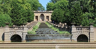
Meridian Hill Park is an urban park in Washington, D.C., located in the Meridian Hill neighborhood that straddles the border between Adams Morgan and Columbia Heights, in Northwest D.C. The park was built between 1912-40 and covers 12-acre (49,000 m2). Meridian Hill Park is bordered by 15th, 16th, W, and Euclid streets NW, and sits on a prominent hill 1.5 miles (2.4 km) directly north of the White House. Since 1969, the name Malcolm X Park is used by some in honor of Malcolm X.

Glover Park is a neighborhood in northwest Washington, D.C., about a half mile north of Georgetown and just west of the United States Naval Observatory and Number One Observatory Circle. Every morning and evening, Glover Park residents can hear the Naval Observatory play the sounding of colors synchronized to the nation's Master Clock. It is named after Charles Carroll Glover.

Lanier Heights is a small urban neighborhood located in the northwest section of Washington, D.C. It was one of the early planned subdivisions which were created inside the District of Columbia, but which lay outside of the original, officially planned City of Washington. Situated two miles north of the White House, Lanier Heights is within the larger and newer neighborhood of Adams Morgan, and is usually considered to be a part of that more prominent locale.
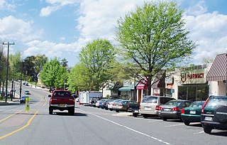
Westover is a neighborhood in Arlington County, Virginia, The neighborhood has been named to the National Register of Historic Places. It is centered on Washington Boulevard between North McKinley Road and North Longfellow Street.

Woodley Park is a neighborhood in Northwest, Washington, DC. It is bounded on the north by Woodley Road and Klingle Road, on the east by the National Zoo and Rock Creek Park, on the south by Calvert Street, on the southwest by Cleveland Avenue, and on the west by 34th Street.
The City of Oklahoma City uses Special Zoning Districts as a tool to maintain the character of many neighborhood communities.

Crystal Heights was a design by American architect Frank Lloyd Wright for a hotel, apartment, and shopping complex in Washington, D.C. The project would have been built on one of the largest remaining undeveloped tracts in the city, known as the Oak Lawn estate or Temple Heights, on the edge of the Adams Morgan and Dupont Circle neighborhoods. The site was bounded by 19th Street, Columbia Road, Connecticut Avenue, and Florida Avenue, all in the northwest quadrant.
Capitol View is a neighborhood located in southeast Washington, D.C., in the United States. It is bounded by East Capitol Street to the north, Central Avenue SE to the southwest and south, and Southern Avenue SE to the southeast. Still overwhelmingly African-American, it is a thriving middle class neighborhood.

Sixteenth Street Heights is a large neighborhood of rowhouses, duplexes, and American Craftsman and American Foursquare detached houses in Northwest Washington, D.C.
West Campus is a neighborhood in central Austin, Texas west of Guadalupe Street and its namesake, the University of Texas at Austin. Due to its proximity to the university, West Campus is heavily populated by college students.
Meridian Hill is a small urban neighborhood in Washington, D.C., located in Northwest D.C. Meridian Hill is often considered to be a part of the larger neighborhoods of Adams Morgan and Columbia Heights, which it sits between. The neighborhood is primarily residential, though it also hosts a notable amount of diplomatic missions and embassies.

The Sixteenth Street Historic District is a 1.25-mile (2.01 km) linear historic district in Washington, D.C., that includes all structures along 16th Street NW between H Street and Florida Avenue. The district's southern boundary is bordered by Lafayette Square, just north of the White House, and Meridian Hill Park on its northern boundary. It includes an eclectic mix of architectural styles on one of the city's most historic and important numbered streets including single and multi-family residential buildings, embassies, hotels, churches, and office buildings.

The Height of Buildings Act of 1910 was an Act of Congress passed by the 61st United States Congress on June 1, 1910 to limit the height of buildings in the District of Columbia, amending the Height of Buildings Act of 1899. The new height restriction law was more comprehensive than the previous law, and generally restricts building heights along residential streets to 90 feet (27 m), and along commercial corridors to the width of the right-of-way of the street or avenue on which a building fronts, or a maximum of 130 feet (40 m), whichever is shorter.

Oak Lawn was a large house and wooded estate that once stood on the edge of today's Dupont Circle and Adams Morgan neighborhoods in Washington, D.C. The estate was bounded by 19th Street, Columbia Road, Connecticut Avenue, and Florida Avenue. Previously called Widow's Mite, the estate was originally several hundred acres, but by the 19th century, had been reduced to around 10 acres. The house was built around 1820 and was greatly expanded in 1873 by Thomas P. Morgan, one half of the eponym of the Adams Morgan neighborhood. A large oak tree, nicknamed the Treaty Oak, was reportedly hundreds of years old and stood just a few yards from the house.
