Reno (Washington, D.C.)

Last updated
Reno
Fort Reno - NPS Acquisition - 009.jpg
Photograph of Reno taken during its clearance.
Coordinates: 38°57′07″N77°04′33″W / 38.952°N 77.0759°W / 38.952; -77.0759
Country United States
District Washington, D.C.
WardWard 3
Subdivision1869
Clearedc.1956

Reno was a town and then neighborhood in Washington, D.C. that existed from the 1860s into the mid-twentieth century on the ground that is now Fort Reno Park in the Tenleytown neighborhood. The town's residents were largely African American, which eventually led to its clearance for Fort Reno Park and Alice Deal Middle School. Its original developers referred to it as Reno City, however this name faded from use before the 1920s.

Contents

History

The land lies on a promontory and was mostly part of the "Fletchall's Chance" land patent. [1] In 1853, a Treasury Department official named Giles Dyer purchased the land to establish a 62-acre estate, where he held several slaves. Upon Dyer's death in 1856, the property was left to his wife, Jane, who managed the farm until the United States government during the Civil War. Union Army engineers constructed a fortress to surveil Wisconsin Avenue. Originally named Fort Pennsylvania, it was renamed after Union general Jesse L. Reno after his death during the Battle of South Mountain.

In 1867, two years after the Civil war had ended, the Dyer family attempted to subdivide and sell the property, but were unable to because Giles Dyer's will was invalid. As a result, the family settled by hiring real estate brokers called Newell Onion and Alexander Butts to subdivide the property as small, affordable homesites.. The pair divided the land into over 1,000 residential lots "of 2,500 square feet each, and one half of these...at the low figure of $12.50" as advertised in the July 27, 1869 issue of the Evening Star. They called this new subdivision “Reno City.” [2] [3] [4]

Although it is possible that freedpeople, either laborers employed to build forts or “contrabands”, had settled around Fort Reno prior to the end of the war, evidence of such is minimal. In a report for Jane Dyer regarding the occupation property, E. E. Camp of the Quartermaster's Department described the layout to Montgomery C. Meigs noted, “Twenty acres by Fortifications, the remaining Fifty acres by barracks, Camps and as parade grounds…” but makes no mention of any home made by and for Black laborers. [5] Rather it appears that Renos's Black population began settling in around the area after the Civil War. For example, the 1870 Census counts a Black family with a surname Jones lived in Tenleytown in Reno. With a three-year-old child born in Maryland, it is clear that Madison and Catherine Jones and their family had not lived in Reno for very long. [6]

Later census data shows a rise in Reno's Black population over the course of a couple of decades. In a local police census conducted in 1897, the data collected noted a 74 percent increase of Black people living in the area from the data reported five years earlier. [1]

By the year 1872, Reno was home to a Black church: Rock Creek Baptist Church, located on the corner of what is now Nebraska Avenue and Chesapeake Street. [7] According to a 1970s oral history with a displaced Reno resident, Mary Daniel, the church often sponsored events such as picnics, pageants, Sunday School trips to the National Zoo. Reno's second Black church, St. Mark's Methodist Episcopal Church, was founded in 1888, Reno's final local church, St. George's Episcopal Church was founded as a mission of St. Albans Parish in 1913. [8]

At the request of Reno's African American residents, the District of Columbia Commissioners constructed the segregated Reno School in 1903.

Clearance

Demolition of 3900 Emory Place by Works Progress Administration workers in 1936. Fort Reno - NPS Demolition - 003.jpg
Demolition of 3900 Emory Place by Works Progress Administration workers in 1936.

However, as early as 1901, the presence of this African American neighborhood in what were becoming elite segregated suburbs presented a problem for white developers. They began efforts to removing the community and redeveloping the land. [9] [2] During the 1920s, developer the Chevy Chase Land Company and the Chevy Chase Citizens’ Association lobbied the federal government to purchase or condemn Reno for the development of schools and a park for Chevy Chase residents’ use. In November 1925, the National Capital Park Commission voted to clear the Reno neighborhood for schools and park and asked the United States Congress, which directly administered the District of Columbia between 1873 and 1975, to pay for it separately. Within weeks, bills to eradicate Reno were introduced in both houses and endorsed by the appointed city managers, the Board of Commissioners of the District of Columbia. In march of 1926, three Black men, James Neill, Thomas Walker, and Thomas Johnson hurried to the Capitol, and were given the opportunity to plead for Reno's non-removal in public hearings. [3] [2] Transcripts of the hearings show these men and several residents including Thornton Lewis, the multiple-time elected Vice President of the Reno Citizens' Association (RCA) argued fervently to save their homes from destruction and themselves from removal. [10]

Despite the clear opposition, desire had not faltered amongst Reno's surrounding white neighbors and city officials to continue efforts to remove and redevelop Reno. In 1929, the National Capital Park and Planning Commission (NCPPC) began to buy houses in Reno, threatening the use of eminent domain to owners that refused to sell. Evidence that the clearance of Reno was racially motivated is robust. In a NCPPC meeting in February 1928, after a vote in general support of Reno's redevelopment, NCPPC member Ulysses S. Grant III stated, “There have been many schemes to get the colored settlements out of there, and this is merely one way of doing it.” [3] Similarly, a white employee at the waterworks in Reno related to a research assistant of E. Franklin Frazier that Reno was being cleared as part of a deliberate segregationist plot. [11] Through the 1930 and into the late 1940s, NCPPC continued to make offers and buy Reno property.

Legacy

Reno's citizens left as they were bought out or evicted. Their houses were demolished and the ground was redeveloped. Today, Alice Deal Middle School and Fort Reno Park occupy the same land that where Reno's houses stood. The Reno School survived and was restored in 2014 and is now a wing of the Deal school. A prominent physical relic of Reno is a fire hydrant that stands solitarily on Fort Reno Park.

Many of the individuals who were involved in clearing Reno were major figures in urban planning at the time, and others would go on to be influential. Melvin Hazen went on to serve as District Commissioner for nearly a decade. The membership of the National Capital Park and Planning Commission that voted multiple times to clear Reno included Frederic Delano, architect Milton Medary, developer J. C. Nichols, and landscape architect Frederick Law Olmsted Jr. In addition to Ulysses S. Grant III, commission staff who worked on the project included director of the National Resource Planning Board Charles Eliot II, director of the National Park Service Conrad L. Wirth, and John Nolen Jr. Grant and Nolen continued to work at NCPPC, developing and overseeing plans for Southwest DC's urban renewal in the 1950s and the development the mostly unbuilt highway system for DC.

See also

Fort Reno Park

Chevy Chase (Washington, D.C.)

Related Research Articles

<span class="mw-page-title-main">Chevy Chase, Maryland</span> Unincorporated community in Maryland, United States

Chevy Chase is the name of both a town and an unincorporated census-designated place that straddle the northwest border of Washington, D.C., and Montgomery County, Maryland, United States. Several settlements in the same area of Montgomery County and one neighborhood of Washington include Chevy Chase in their names. These villages, the town, and the CDP share a common history and together form a larger community colloquially referred to as Chevy Chase.

<span class="mw-page-title-main">Tenleytown</span> Place in the United States

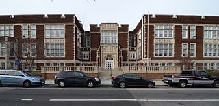
Tenleytown is a historic neighborhood in Northwest, Washington, D.C.

<span class="mw-page-title-main">Mount Pleasant (Washington, D.C.)</span> Neighborhood of Washington, D.C.

Mount Pleasant is a neighborhood in the northwestern quadrant of Washington, D.C. It is bounded by Rock Creek Park to the north and west; Harvard Street NW to the south; and 16th Street NW to the east. It is north of Adams Morgan and west of Columbia Heights. It is home to about 10,000 people.

<span class="mw-page-title-main">Northwest (Washington, D.C.)</span> Quadrant in the United States

Northwest is the northwestern quadrant of Washington, D.C., the capital of the United States, and is located north of the National Mall and west of North Capitol Street. It is the largest of the four quadrants of the city, and it includes the central business district, the Federal Triangle, and the museums along the northern side of the National Mall, as well as many of the District's historic neighborhoods.

<span class="mw-page-title-main">Friendship Heights</span> Neighborhood in Ward 3, United States

Friendship Heights is an urban commercial and residential neighborhood in northwest Washington, D.C., and southern Montgomery County, Maryland. Though its borders are not clearly defined, Friendship Heights consists roughly of the neighborhoods and commercial areas around Wisconsin Avenue north of Fessenden Street NW and Tenleytown to Somerset Terrace and Willard Avenue in Maryland, and from River Road in the west to Reno Road and 41st Street in the east. Within Maryland west of Wisconsin Avenue is the Village of Friendship Heights, technically a special taxation district.

<span class="mw-page-title-main">Chevy Chase (Washington, D.C.)</span> Place in the United States

Chevy Chase is a neighborhood in northwest Washington, D.C. It borders Chevy Chase, Maryland, a collection of similarly affluent neighborhoods.

<span class="mw-page-title-main">Neighborhoods in Washington, D.C.</span>

Neighborhoods in Washington, D.C., United States are distinguished by their history, culture, architecture, demographics, and geography. The names of 131 neighborhoods are unofficially defined by the D.C. Office of Planning. Neighborhoods can be defined by the boundaries of wards, historic districts, Advisory Neighborhood Commissions, civic associations, and business improvement districts (BIDs); these boundaries will overlap. The eight wards each elect a member to the Council of the District of Columbia and are redistricted every ten years.

<span class="mw-page-title-main">Francis G. Newlands</span> American politician

Francis Griffith Newlands was an American politician and land developer who served as United States representative and Senator from Nevada and a member of the Democratic Party.

<span class="mw-page-title-main">Park View (Washington, D.C.)</span> Neighborhood of Washington, D.C.

Park View is a neighborhood in central Washington, D.C., immediately north of Howard University.

<span class="mw-page-title-main">Fort Reno Park</span> Park in Washington, D.C., U.S.

Fort Reno Park is an urban park in the Tenleytown neighborhood of Northwest Washington, D.C. It is named after Fort Reno, one of the only locations in the District of Columbia to see combat during the American Civil War. The park was established in the 1920s to clear an African American neighborhood called Reno from the site, in what was becoming an affluent white suburban area.

<span class="mw-page-title-main">Streetcars in Washington, D.C., and Maryland</span>

Streetcars and interurbans operated in the Maryland suburbs of Washington, D.C., between 1890 and 1962. Lines in Maryland were established as separate legal entities, but eventually they were all owned or leased by DC Transit. Unlike the Virginia lines, the Washington and Maryland lines were scheduled as a single system. Most of the streetcar lines were built with grand plans in mind, but none succeeded financially. A combination of the rise of the automobile, various economic downturns and bustitution eventually spelled the end of streetcars in southern Maryland.

<span class="mw-page-title-main">Wakefield (Washington, D.C.)</span> Place in the United States

Wakefield is a neighborhood in the Northwest quadrant of Washington, D.C., bounded by Albemarle Street NW to the south, Nebraska Avenue NW to the west, and Connecticut Avenue to the east. It is served by the Van Ness-UDC and Tenleytown-AU station on the Washington Metro's Red Line.

<span class="mw-page-title-main">Barnaby Woods</span> Place in the United States

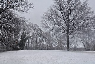
Barnaby Woods is a neighborhood in the Northwest quadrant of Washington, D.C., wedged between Rock Creek Park and Montgomery County, Maryland. It is bounded on the north by Aberfoyle Place, on the west by Western Avenue, on the south by Tennyson Street, and on the east by Oregon Avenue. Barnaby Woods is entirely residential, with no commercial zoning whatsoever, and the housing consists primarily of 1930s colonial homes on large parcels of land although on Unicorn Lane NW there are only townhouses.

<span class="mw-page-title-main">Fort Reno (Washington, D.C.)</span> American Civil War fort in Washington, D.C., U.S.

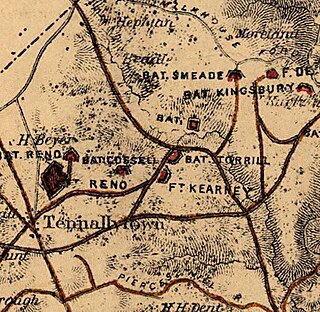
Fort Reno was a major fortification of the Civil War Defenses of Washington, located in what is now the Tenleytown neighborhood of Washington, D.C. The fort sat on the highest natural point in the District of Columbia. Fort Reno played a part in the only Civil War battle to take place in the District of Columbia, at the Battle of Fort Stevens.

<span class="mw-page-title-main">Fort Kearny (Washington, D.C.)</span>

Fort Kearny was a fort constructed during the American Civil War as part of the defenses of Washington, D.C. Located near Tenleytown, in the District of Columbia, it filled the gap between Fort Reno and Fort DeRussy north of the city of Washington. The fort was named in honor of Maj. Gen. Philip Kearny of the Union Army, who was killed at the Battle of Chantilly on September 1, 1862. Three batteries of guns supported the fort, and are considered part of the fort's defenses.

<span class="mw-page-title-main">Fort Bayard (Washington, D.C.)</span> Historic fort in Washington, D.C.

Fort Bayard was an earthwork fort constructed in 1861 northwest of Tenleytown in the District of Columbia as part of the defenses of Washington, D.C., during the American Civil War. It never faced major opposition during the conflict and was decommissioned following the surrender of Robert E. Lee's Army of Northern Virginia. Named after Brigadier General George Dashiell Bayard, who was killed at the Battle of Fredericksburg, the site of the fort is in Boundary Park, located at the intersection of River Road and Western Avenue NW in Washington, D.C., and is maintained by the U.S. National Park Service. No trace of the fort remains, though a marker commemorating its existence has been erected by the Park Service.

<span class="mw-page-title-main">Grant Road Historic District</span> Historic district in Washington, D.C., United States

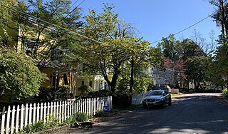
The Grant Road Historic District is located in the Tenleytown neighborhood of Washington, D.C. The two-block historic district is what remains of a former settlement in rural Washington County in the District of Columbia. It includes 13 contributing buildings and the road itself, a narrow remnant of a country road that was used by soldiers in the Civil War. Following the war, the road was named after Civil War general and President Ulysses S. Grant. Grant Road developed into a residential street lined with mostly small, two-story homes for working-class people.

<span class="mw-page-title-main">Western Avenue (Washington, D.C.)</span>

Western Avenue is one of three boundary streets between Washington, D.C., and the state of Maryland. It follows a southwest-to-northeast line, beginning at Westmoreland Circle in the south and ending at Oregon Avenue NW in the north. It is roughly 3.5 miles (5.6 km) in length. First proposed in 1893, it was constructed somewhat fitfully from about 1900 to 1931.

Woodmont is a neighborhood in northwest Washington, D.C.

<span class="mw-page-title-main">The Chevy Chase Land Company</span> American real estate company

The Chevy Chase Land Company is a real estate holding and development company based in suburban Washington, D.C.

References

  1. 1 2 Judith Beck, Helm (1981). Tenleytown, D.C.: Country Village into City Neighborhood. Washington: Tennally Press. pp. 193–196.
  2. 1 2 3 "Fort Reno: Growth and Displacement". ArcGIS StoryMaps. 4 February 2021. Retrieved 2021-05-17.
  3. 1 2 3 Flanagan, Neil (2017-11-02). "The Battle of Fort Reno". Washington City Paper. Retrieved 2021-05-17.
  4. "Display Ad". Evening Star. 1869-07-27. Retrieved 2021-05-17.
  5. Meigs, M. C. (1863) . [Manuscript/Mixed Material] Retrieved from the Library of Congress, https://www.loc.gov/item/mss325400254/.
  6. U.S. Census Bureau (1870).1870 Census: Volume 1. The Statistics of the Population of the United States. Retrieved from https://www.census.gov/library/publications/1872/dec/1870a.html
  7. "Tenleytown Historical Society: Tenleytown Neighborhoods & Subdivisions - Reno City". www.tenleytownhistoricalsociety.org. Retrieved 2021-05-17.
  8. "Home of 'God's Flock". Washington Post. 1913-06-06.
  9. "A Proposition to Purchase Land near Fort Reno Reservoir". Evening Star. 1901-05-04.
  10. United States. Congress. Senate. Committee on the District of Columbia. (1926). Acquirement of Reno Subdivision in D.C.: hearings before the United States Senate Committee on the District of Columbia, Sixty-Ninth Congress, first session, on June 2, 1926. Washington: U.S. G.P.O.. https://hdl.handle.net/2027/umn.31951d02091512p
  11. Asch, Chris Myers; Musgrove, George Derek (2017-11-06). Chocolate City. University of North Carolina Press. p. 258. doi:10.5149/northcarolina/9781469635866.001.0001. ISBN   978-1-4696-3586-6.

Commons-logo.svg Media related to Reno (Washington, D.C.) at Wikimedia Commons