Alabama
Population over 100,000
Population 25,000 to 99,999
Population 10,000 to 24,999
Population 5,000 to 9,999
Population 1,000 to 4,999
Population 100 to 999
Population under 100
★No longer African-American majority as of the 2020 Census
★African-American majority as of the 2010 Census
★New jurisdiction first appearing in the 2010 Census

Alcorn County is a county located in the northeastern portion of the U.S. state of Mississippi. As of the 2020 census, the population was 34,740. Its county seat is Corinth. The county is named in honor of Governor James L. Alcorn.

Oroville East or Kelly Ridge is a census-designated place (CDP) in Butte County, California, United States. The population was 8,280 at the 2010 census, down from 8,680 at the 2000 census. Most citizens are dependent on the commerce of Oroville, and the vast majority of high school students in Kelly Ridge attend Las Plumas High School. The community of Kelly Ridge sits at Lake Oroville and offers direct access to boating, camping, fishing and a variety of water sports.

Lanare is a community and census-designated place (CDP) in Fresno County, California, United States. The population was 589 at the 2010 census, up from 540 at the 2000 census. Lanare is located 24 miles (39 km) south-southwest of Fresno, at an elevation of 207 feet. The name is derived from Llewellyn A. Nares, the community developer. Lanare is currently served by the Riverdale Post Office, zip code 93656, and students attend public school in Riverdale.

Walnut Park is a census-designated place (CDP) in Los Angeles County, California, United States, adjacent to Florence-Graham, Huntington Park and South Gate. The population was 15,966 at the 2010 census, down from 16,180 at the 2000 census.

Cutler is a community and census-designated place (CDP) in Tulare County, California, United States. The population was 5,000 at the 2010 census, up from 4,491 at the 2000 census. The population as of 2019 was 5,214.

Blue Hills is a community in Hartford County, Connecticut, United States, encompassing the northwestern corner of the city of Hartford and the southeastern corner of the town of Bloomfield. The Bloomfield portion is listed by the U.S. Census Bureau as a census-designated place (CDP), with a population of 2,762 at the 2020 census.

Pa'auilo is a census-designated place (CDP) in Hawaiʻi County, Hawaii, United States. The population was 618 at the 2020 census.

Madison Park is an unincorporated community and census-designated place (CDP) located within Old Bridge Township, in Middlesex County, in the U.S. state of New Jersey. As of the 2010 United States Census, the CDP's population was 7,144. The name "Madison Park" reflects Old Bridge's original name of "Madison Township" which it had when it was formed on March 2, 1869 from portions of South Amboy Township, until November 5, 1975, when voters approved a referendum changing the township's name to Old Bridge Township.

West Belmar is an unincorporated community and census-designated place (CDP) within Wall Township, in Monmouth County, in the U.S. state of New Jersey. At the 2010 census, the CDP's population was 2,493.

Brinckerhoff is a hamlet and census-designated place (CDP) in Dutchess County, New York, United States. The population was 2,900 at the 2010 census. It is part of the Poughkeepsie–Newburgh–Middletown, NY Metropolitan Statistical Area as well as the larger New York–Newark–Bridgeport, NY-NJ-CT-PA Combined Statistical Area.
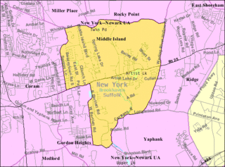
Middle Island is a hamlet and census-designated place (CDP) in the Town of Brookhaven, Suffolk County, New York, United States. The population was 10,483 at the 2010 census. It is situated between the hamlets of Coram and Ridge, to the west and east, respectively, and Rocky Point and Yaphank to the north and south. The name derives from the fact that it lies approximately halfway between the eastern and western ends of Long Island as well as halfway between the northern and southern boundaries.

Whitesboro is an unincorporated community and census-designated place (CDP) located within Middle Township in Cape May County, in the U.S. state of New Jersey. Until the 2000 census the area had been part of the Whitesboro-Burleigh CDP, which was split in 2010 into separate CDPs for Burleigh and Whitesboro. As of the 2010 United States Census, the CDP's population was 2,205. Whitesboro was founded as a planned residential community for African Americans and has the majority of the township's black population.

Old Road, officially known as the Town of Old Road, is a town located on a roadstead in the parish of Saint Mary, Antigua and Barbuda. It is overlooked by Boggy Peak, which lies to its northwest. Old Road was founded in the 1700s, and in the 1850s was still a tiny settlement of 96, smaller than its neighbour to the west, Urlings. Old Road has since grown to a population of 1,251 in 2011, and is now the tenth largest settlement in the country. Old Road is smaller than Willikies, but is larger than Montclear, Skyline, and Potters Village. Old Road is separated from the rest of Antigua by the Shekerley Mountains. The village is located on Andy Roberts Drive which to the east, merges onto Fig Tree Drive leading to John Hughes, and to the west, continues through Urlings, Crabs Hill, and Johnsons Point before merging onto Valley Road in Ffryes village.

The Anchorage Metropolitan Statistical Area, as defined by the United States Census Bureau, is an area consisting of the Municipality of Anchorage and the Matanuska-Susitna Borough in the south central region of Alaska.

The Safford Micropolitan Statistical Area, as defined by the United States Census Bureau, is a micropolitan statistical area (μSA) consisting of one county in eastern Arizona, anchored by the city of Safford.
This article presents official statistics gathered during the COVID-19 pandemic in Russia.