Wahpeton micropolitan area

Last updated

The Wahpeton Micropolitan Statistical Area, as defined by the United States Census Bureau, is an area consisting of two counties one in southeast North Dakota and one in west central Minnesota, anchored by the city of Wahpeton, North Dakota. As of the 2010 census, the μSA had a population of 22,897.

United States Census Bureau Bureau of the United States responsible for the census and related statistics

The United States Census Bureau is a principal agency of the U.S. Federal Statistical System, responsible for producing data about the American people and economy. The Census Bureau is part of the U.S. Department of Commerce and its director is appointed by the President of the United States.

North Dakota State of the United States of America

North Dakota is a U.S. state in the midwestern and northern regions of the United States. It is the nineteenth largest in area, the fourth smallest by population, and the fourth most sparsely populated of the 50 states. North Dakota was admitted to the Union on November 3, 1889, along with its neighboring state, South Dakota. Its capital is Bismarck, and its largest city is Fargo.

Minnesota State of the United States of America

Minnesota is a state in the Upper Midwest, Great Lakes, and northern regions of the United States. Minnesota was admitted as the 32nd U.S. state on May 11, 1858, created from the eastern half of the Minnesota Territory. The state has a large number of lakes, and is known by the slogan the "Land of 10,000 Lakes". Its official motto is L'Étoile du Nord.

Contents

The Wahpeton Micropolitan Statistical Area is a component of the Fargo Wahpeton, ND-MN Combined Statistical Area.

Fargo, North Dakota City in North Dakota, United States

Fargo is a city in and the county seat of Cass County, North Dakota, United States. The most populous city in the state, it accounts for nearly 17% of the state population. According to the 2017 United States Census estimates, its population was 122,359, making it the 225th-most populous city in the United States. Fargo, along with its twin city of Moorhead, Minnesota, as well as the adjacent cities of West Fargo, North Dakota and Dilworth, Minnesota, form the core of the Fargo-Moorhead, ND-MN Metropolitan Statistical Area, which in 2017 contained a population of 241,356.

Counties

Richland County, North Dakota County in the United States

Richland County is a county in the U.S. state of North Dakota. As of the 2010 United States Census, the population was 16,321. Its county seat is Wahpeton.

Wilkin County, Minnesota County in the United States

Wilkin County is a county in the U.S. state of Minnesota. As of the 2010 United States Census, the population of Wilkin County was 6,576. Its county seat is Breckenridge. The county is named for Colonel Alexander Wilkin, a lawyer who served as Minnesota’s U.S. marshal and was later killed in the Civil War.

Communities

Wahpeton, North Dakota City in North Dakota, United States

Wahpeton is a city in Richland County, in southeastern North Dakota, United States. It is located along the Bois de Sioux River at its confluence with the Otter Tail River, forming the Red River of the North. Wahpeton is the county seat of Richland County. The U.S. Census Bureau estimated the city's 2015 population was 7,899.

Breckenridge, Minnesota City in Minnesota, United States

Breckenridge is a city and county seat of Wilkin County, Minnesota, United States. The population was 3,386 at the 2010 census.

Hankinson, North Dakota City in North Dakota, United States

Hankinson is a city in Richland County, North Dakota, United States. The population was 919 at the 2010 census. Hankinson was founded in 1886. It is part of the Wahpeton, ND–MN Micropolitan Statistical Area.

Townships

Richland County

Wilkin County

Demographics

Historical population
Census Pop.
1860 40
1870 295637.5%
1880 5,5031,765.4%
1890 15,097174.3%
1900 25,46768.7%
1910 28,72212.8%
1920 31,0748.2%
1930 30,799−0.9%
1940 30,9940.6%
1950 30,432−1.8%
1960 29,474−3.1%
1970 27,478−6.8%
1980 27,6610.7%
1990 25,664−7.2%
2000 25,136−2.1%
2010 22,897−8.9%
Est. 201122,837−0.3%
U.S. Decennial Census
2011 estimate

As of the census [1] of 2000, there were 25,136 people, 9,437 households, and 6,353 families residing within the μSA. The racial makeup of the μSA was 97.10% White, 0.29% African American, 1.31% Native American, 0.22% Asian, 0.03% Pacific Islander, 0.24% from other races, and 0.82% from two or more races. Hispanic or Latino of any race were 0.93% of the population.

The median income for a household in the μSA was $37,096, and the median income for a family was $45,852. Males had a median income of $31,051 versus $20,618 for females. The per capita income for the μSA was $16,606.

See also

Related Research Articles

The Point Pleasant Micropolitan Statistical Area, as defined by the United States Census Bureau, is an area consisting of two counties – one in West Virginia and one in Ohio – anchored by the city of Point Pleasant, West Virginia.

Clarksburg micropolitan area

The Clarksburg Micropolitan Statistical Area, as defined by the United States Census Bureau, is an area consisting of three counties in North-Central West Virginia, anchored by the city of Clarksburg.

Watertown, South Dakota, micropolitan area

The Watertown Micropolitan Statistical Area, as defined by the United States Census Bureau, is an area consisting of two counties in South Dakota, anchored by the city of Watertown. As of the 2000 census, the μSA had a population of 31,437.

Aberdeen, South Dakota micropolitan area

The Aberdeen Micropolitan Statistical Area, as defined by the United States Census Bureau, is an area consisting of two counties in South Dakota, anchored by the city of Aberdeen. As of the 2010 census, the μSA had a population of 40,602.

Hastings Micropolitan Statistical Area

The Hastings Micropolitan Statistical Area, as defined by the United States Census Bureau, is an area consisting of two counties in Nebraska, anchored by the city of Hastings.

Norfolk Micropolitan Statistical Area

The Norfolk Micropolitan Statistical Area, as defined by the United States Census Bureau, is an area consisting of three counties in Nebraska, anchored by the city of Norfolk.

Kearney Micropolitan Statistical Area

The Kearney Micropolitan Statistical Area, as defined by the United States Census Bureau, is an area consisting of two counties in Nebraska, anchored by the city of Kearney.

New Bern Metropolitan Statistical Area

The New Bern Metropolitan Statistical Area, as defined by the United States Census Bureau, is an area consisting of three counties in the Inner Banks region of eastern North Carolina, anchored by the city of New Bern. The designation of the area was changed from Micropolitan to Metropolitan in 2013.

Roanoke Rapids, North Carolina micropolitan area

The Roanoke Rapids Micropolitan Statistical Area, as defined by the United States Census Bureau, is an area consisting of two counties in North Carolina, anchored by the city of Roanoke Rapids.

Ardmore, Oklahoma micropolitan area

The Ardmore Micropolitan Statistical Area, as defined by the United States Census Bureau, is an area consisting of two counties in South Central Oklahoma, anchored by the city of Ardmore.

The Burlington, IA-IL Micropolitan Statistical Area, as defined by the United States Census Bureau, is an area consisting of two counties – one in southeast Iowa and the other in west central Illinois, anchored by the city of Burlington, Iowa.

Mount Vernon, Illinois micropolitan area human settlement in Illinois, United States of America

The Mount Vernon, IL Micropolitan Statistical Area, as defined by the United States Census Bureau, is an area consisting of two counties in southern Illinois, anchored by the city of Mount Vernon.

Jacksonville, Illinois micropolitan area

The Jacksonville, IL Micropolitan Statistical Area, as defined by the United States Census Bureau, is an area consisting of two counties in west central Illinois, anchored by the city of Jacksonville.

Camden, Arkansas micropolitan area

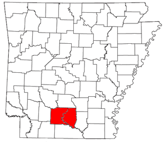
The Camden Micropolitan Statistical Area, as defined by the United States Census Bureau, is an area consisting of two counties in the U.S. state of Arkansas, anchored by the city of Camden.

Salina, Kansas micropolitan area

The Salina Micropolitan Statistical Area, as defined by the United States Census Bureau, is an area consisting of two counties in Kansas, anchored by the city of Salina.

Emporia, Kansas micropolitan area

The Emporia Micropolitan Statistical Area, as defined by the United States Census Bureau, is an area consisting of two counties in Kansas, anchored by the city of Emporia.

Safford, Arizona micropolitan area

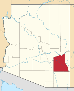
The Safford Micropolitan Statistical Area, as defined by the United States Census Bureau, is an area consisting of one county in eastern Arizona, anchored by the city of Safford.

Alexander City micropolitan area

The Alexander City Micropolitan Statistical Area is a former micropolitan statistical area that consisted of two counties in Alabama, anchored by the city of Alexander City, as defined by the United States Census Bureau. As of the 2010 census, the μSA had a population of 53,155.

Brainerd micropolitan area

The Brainerd Micropolitan Statistical Area, as defined by the United States Census Bureau, is an area consisting of Cass County and Crow Wing County in central Minnesota, anchored by the city of Brainerd. As of February 4, 2011 estimate placed the population at 91,067.

Dickinson, North Dakota micropolitan area

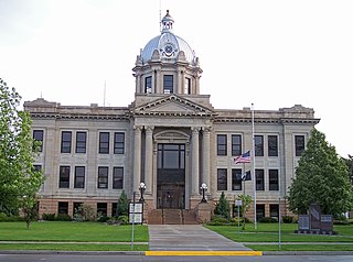
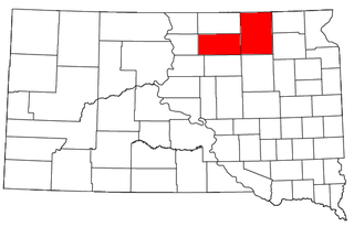
The Dickinson Micropolitan Statistical Area, as defined by the United States Census Bureau, is an area consisting of two counties in North Dakota, anchored by the city of Dickinson. As of the 2010 census, the μSA had a population of 24,982.

References