Treece, Kansas

Last updated

Treece, Kansas
Treece KS.jpg
Treece (2016)
Cherokee County Kansas Incorporated and Unincorporated areas Treece Highlighted.svg
Location within Cherokee County and Kansas
Map of Cherokee Co, Ks, USA.png
Coordinates: 37°0′3″N94°50′36″W / 37.00083°N 94.84333°W / 37.00083; -94.84333 [1]
Country United States
State Kansas
County Cherokee
Founded1910s
Disincorporated2012 [2]
Area
  Total0.1 sq mi (0.2 km2)
  Land0.1 sq mi (0.2 km2)
  Water0 sq mi (0.0 km2)
Elevation
[1]
840 ft (260 m)
Population
 (2010) [3]
  Total138
  Estimate 
(2016) [4] [5]
1
  Density1,400/sq mi (690/km2)
Time zone UTC-6 (CST)
  Summer (DST) UTC-5 (CDT)
ZIP code
66778 [6]
Area code 620
FIPS code 20-71350 [1]
GNIS ID 469375 [1]

Treece is a ghost town in Cherokee County, Kansas, United States, [1] and part of the historic Tri-State Mining District. As of the 2010 census, the city population was 138. [3] As of May 2012 the city was abandoned and most buildings and other facilities demolished due to pervasive problems with lead pollution resulting from past mining. Two people who had refused an Environmental Protection Agency (EPA) buyout remained in 2012, [4] then one died in 2016. [5]

Contents

History

Treece and neighboring former cities Picher, Cardin and Douthat were formed as a result of mining operations in the early 20th century. Realtor J. O. Treece lent the town his name. [7] The first post office in Treece was established in 1917. [8] Treece was a major supplier of lead, zinc, and iron ore. During its maximum production, Treece and Picher combined had a population of over 20,000 and produced $20 billion worth of ore mainly during World War I and World War II. After the 1970s, ore production declined rapidly as did the city's population. [9] In 1981 the Environmental Protection Agency deemed the Tri-State Mining District as contaminated and promised to take actions to clean up the area. [10]

The cleanup of Tri-State Mining District lands was divided for EPA purposes into a total of four National Priority List (NPL) Superfund Sites: the Cherokee County Site, Cherokee County, Kansas; the Orongo-Duenweg Site, Jasper County, Missouri; the Newton County Mine Tailings Site, Newton County, Missouri; and the Tar Creek Site, Ottawa County, Oklahoma. [11] The Cherokee County Superfund Site was in turn divided into seven subsites that were grouped and divided into nine operable units (OUs). The area around Treece was designated OU4. [12] Thus, while Treece is located less than a mile north of Picher, Oklahoma, a town which was closed due to lead pollution, Treece was located at a different Superfund site. Picher's residents' property was bought out by the Environmental Protection Agency. Residents of Treece also demanded a buy-out, but at first were not certain of receiving one. [13] As of September 2009, it was reported that the U.S. Environmental Protection Agency wanted to clean up the soil in Treece, instead of moving its residents away. [14] Congress, however, passed an environmental appropriations bill on October 29, 2009, that authorized the EPA to buy out the town. [15] Residents had until August 31, 2010 to apply for a Federal buyout [16] and offers were to be made to the 80 residents who applied in December. [17] As of May 2, 2012 only one couple had rejected the buyout offer and remained in Treece living in a double-wide trailer. Other than their location all other facilities in the former city have been sold, moved, or demolished. [4]

Despite all the money spent by the EPA to relocate the people of Treece and tear down the buildings left behind, there has not been much clean up of the mine waste done.[ citation needed ]

In 2012, the State of Kansas officially disincorporated the city of Treece. [2]

Contamination

Treece, Kansas was deemed as uninhabitable and contaminated by the Environmental Protection Agency because of the large chat piles and leftover mine tailings that still exist in the abandoned town today. Wes Enzinna, a writer for The New York Times, visited Treece in 2010 and interviewed some of the remaining residents; they claimed that years before Treece, Kansas was ever ruled contaminated by the EPA, children who swam in the local Tar Creek Superfund site would end up with chemical burns (superficially resembling sunburn) all over their bodies. [4]

The reason that the chat piles and mine tailings are so dangerous is because of the high amount of lead that is still left in the rock. While short-term exposure to lead will not necessarily harm a person, if one is exposed for long periods of time, which the people living in Treece were, it can result in high blood pressure, heart disease, kidney disease, and reduced fertility. [18] No studies have been done to determine the effects that the toxic environment left on the health of former residents of Treece, Kansas.

Some of the chat piles in Treece are up to 200 ft (61 m) tall and the dust that is blown off from these piles “still contains enough metal to make blood-lead levels among young children here three times higher than the national average”, [4] indicating that the residents of Treece had been dealing and living with dangerous amounts of toxic waste in their backyards for 50–60 years before anything was done to clean up the area.

When the mining companies stopped mining, they shut off the water pumps that kept the mines from flooding. When the floodwater traveled through the mining tunnels, it picked up all the leftover traces of minerals that were left behind. The water then found its way into the local Tar Creek and other streams, contaminating the water and ruining the habitat of the local wildlife. [4]

It is important to add that Tar Creek runs through Treece and many other towns in the area that faced the same issues as Treece.

Geography

Treece is located in southeast Kansas adjacent to the Kansas-Oklahoma border just west of U.S. Route 69. Picher, Oklahoma lies one mile to the south. [19]

According to the United States Census Bureau, the city had a total area of 0.1 square miles (0.26 km2), all land.

Demographics

Historical population
CensusPop.Note
1930 749
1940 568−24.2%
1950 378−33.5%
1960 280−25.9%
1970 225−19.6%
1980 194−13.8%
1990 172−11.3%
2000 149−13.4%
2010 138−7.4%
2016 (est.)1−99.3%
U.S. Decennial Census, Census 2000

2000 census

As of the census of 2000, [20] there were 149 people, 59 households, and 37 families residing in the city. The population density was 2,134.9 inhabitants per square mile (824.3/km2). There were 66 housing units at an average density of 945.6 per square mile (365.1/km2). The racial makeup of the city was 85.91% White, 7.38% Native American, 2.01% African American, and 4.70% from two or more races. Hispanic or Latino of any race were 0.67% of the population.

There were 59 households, out of which 33.9% had children under the age of 18 living with them, 47.5% were married couples living together, 10.2% had a female householder with no husband present, and 35.6% were non-families. 33.9% of all households were made up of individuals, and 18.6% had someone living alone who was 65 years of age or older. The average household size was 2.53 and the average family size was 3.26.

In the city the population was spread out, with 30.9% under the age of 18, 7.4% from 18 to 24, 25.5% from 25 to 44, 19.5% from 45 to 64, and 16.8% who were 65 years of age or older. The median age was 37 years. For every 100 females, there were 96.1 males. For every 100 females age 18 and over, there were 106.0 males.

The median income for a household in the city was $22,500, and the median income for a family was $28,125. Males had a median income of $26,250 versus $33,125 for females. The per capita income for the city was $10,122. There were 20.0% of families and 26.4% of the population living below the poverty line, including 40.5% of under eighteens and 19.0% of those over 64.

2010s

As of May 2012, one couple who had rejected an EPA buyout offer remained in Treece. [4]

On August 30, 2016, Timothy Busby, one of the two remaining Treece residents, died at the age of 54. He is survived by his wife, Della Busby, who lived with him in Treece until his death, as well as their three grown children and other relatives.

See also

Next door communities that were also closed down and razed:

Related Research Articles

<span class="mw-page-title-main">Ottawa County, Oklahoma</span> County in Oklahoma, United States

Ottawa County is a county located in the northeastern corner of the U.S. state of Oklahoma. As of the 2020 census, the population was 30,285. Its county seat is Miami. The county was named for the Ottawa Tribe of Oklahoma. It is also the location of the federally recognized Modoc Nation and the Quapaw Nation, which is based in Quapaw.

<span class="mw-page-title-main">Galena, Kansas</span> City in Cherokee County, Kansas

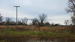
Galena is a city in Cherokee County, Kansas, United States. As of the 2020 census, the population of the city was 2,761.

<span class="mw-page-title-main">Bonne Terre, Missouri</span> City in Missouri, United States

Bonne Terre is a city in St. Francois County, Missouri, United States with a population of 6,864 at the 2010 census. Situated in the Southeast Missouri Lead District, lead mining shaped the history and character of the area from the earliest French settlers in the 1720s until today, even though Bonne Terre Mine established by St. Joseph lead mining company in 1864 closed in 1962. Mine tailing piles eroded, and contaminated the area as dust, posing residential hazards or were washed into the Big River. Only in 1992, the Bonne Terre Mine Tailings Site was listed as a Superfund Site; as of 2022 remediation is still ongoing.

<span class="mw-page-title-main">Cardin, Oklahoma</span> Ghost Town in Oklahoma, United States

Cardin is a ghost town in Ottawa County, Oklahoma, United States. The population was 150 at the 2000 census, but plummeted to 3 at the 2010 census in April 2010.

<span class="mw-page-title-main">Picher, Oklahoma</span> Ghost town in Oklahoma, United States

Picher is a ghost town and former city in Ottawa County, northeastern Oklahoma, United States. It was a major national center of lead and zinc mining for more than 100 years in the heart of the Tri-State Mining District.

<span class="mw-page-title-main">ASARCO</span> American integrated energy company

ASARCO is a mining, smelting, and refining company based in Tucson, Arizona, which mines and processes primarily copper. The company has been a subsidiary of Grupo México since 1999.

<span class="mw-page-title-main">Burke Canyon</span> Human settlement in Idaho, United States

Burke Canyon is the canyon of the Burke-Canyon Creek, which runs through the northernmost part of Shoshone County, Idaho, U.S., within the northeastern Silver Valley. A hotbed for mining in the late-nineteenth and twentieth centuries, Burke Canyon now contains several ghost towns and remnants of former communities along Idaho State Highway 4, which runs northeast through the narrow canyon to the Montana border.

<span class="mw-page-title-main">Midnite Mine</span>

The Midnite Mine is an inactive uranium mine in the Selkirk Mountains of the state of Washington that operated from 1955 to 1965 and again from 1968 to 1981. Located within the reservation of the Spokane Tribe of Indians, it is approximately 8 miles (13 km) from Wellpinit, Stevens County. The mine was listed as a Superfund site under the Comprehensive Environmental Response, Compensation, and Liability Act of 1980 (CERCLA) on May 11, 2000. In addition to elevated levels of radioactivity, heavy metals mobilized in uranium acid mine drainage pose a potential threat to human health and the environment.

<span class="mw-page-title-main">Tar Creek Superfund site</span>

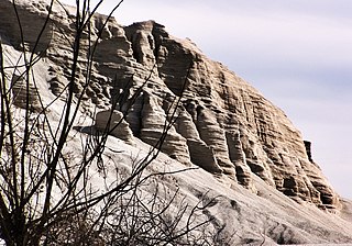
Tar Creek Superfund site is a United States Superfund site, declared in 1983, located in the cities of Picher, Douthat and Cardin, Ottawa County, in northeastern Oklahoma. From 1900 to the 1960s lead mining and zinc mining companies left behind huge open chat piles that were heavily contaminated by these metals, cadmium, and others. Metals from the mining waste leached into the soil, and seeped into groundwater, ponds, and lakes. Because of the contamination, Picher children have suffered elevated lead, zinc and manganese levels, resulting in learning disabilities and a variety of other health problems. The EPA declared Picher to be one of the most toxic areas in the United States.

<span class="mw-page-title-main">Uranium mining and the Navajo people</span> Effects of uranium mining on Navajo

Uranium mining and the Navajo people began in 1944 in northeastern Arizona, northwestern New Mexico, and southeastern Utah.

<span class="mw-page-title-main">Tri-State district</span> Historic U.S. lead-zinc mines

The Tri-State district was a historic lead-zinc mining district located in present-day southwest Missouri, southeast Kansas and northeast Oklahoma. The district produced lead and zinc for over 100 years. Production began in the 1850s and 1860s in the Joplin - Granby area of Jasper and Newton counties of southwest Missouri. Production was particularly high during the World War I era and continued after World War II, but with declining activity. As jobs left the area, the communities declined in population.

Rimini is a ghost town in Lewis and Clark County, Montana, United States. It is one of the oldest mining districts in the state. It was established when silver lodes were discovered in 1864. Other names for the town were Lewis and Clark, Tenmile, Vaughn, Colorado, and Bear Gulch. It was the site of Camp Rimini.

The Atlas Asbestos Mine Superfund Site is located within the Clear Creek Management Area near Fresno County, eighteen miles northwest of Coalinga, California. The mine started operating in 1963, covering 435 acres of a large naturally occurring asbestos deposit. The mine closed in 1979 and was placed in the EPA's National Priorities List (NPL) in 1983 due to the pollution of asbestos in the surrounding soil, air and water creating potential health hazards for local populations and environment.

<span class="mw-page-title-main">New Idria Mercury Mine</span> Quicksilver Mine in California, United States

The New Idria Mercury Mine encompasses 8,000 acres of land in the Diablo Mountain range, incorporating the town of Idria in San Benito County, California. Idria, initially named New Idria, is situated at 36°25′01″N120°40′24″W and 2440 feet (680m) above mean sea level. The area was, in the past, recorded in the US Census Bureau as a rural community; however, Idria has become a ghost town since the closing of once lucrative mining operations in the early 1970s.

<span class="mw-page-title-main">California Gulch</span>

The California Gulch site consists of approximately 18 square miles in Lake County, Colorado. The area includes the city of Leadville, parts of the Leadville Historic Mining District and a section of the Arkansas River from the confluence of California Gulch downstream to the confluence of Two-Bit Gulch. The site was listed as a Superfund site in 1983.

The Burnt Fly Bog Superfund Site is located in Marlboro Township in Monmouth County, New Jersey. Contamination began in the 1950s and 1960s. It was used as a dumping ground for hazardous chemicals and oils. This site was used to reprocess or recycle oil, and it was also used as a landfill during the 1950s. The contamination affected the surface water and soil. The EPA got involved in the 1980s and addressed the situation. Human health concerns were a main part of the EPA getting involved because residents lived only about 1,000 to 2,000 feet around the site. Major components of the remedy included excavation and off-site disposal of contaminated soil from Northerly Wetlands, Tar Patch Area. The back filling of the areas addressed, monitoring of the surface water and sediments, and biological sampling in the Westerly Wetlands. The current status of the site is complete. The remedial stages were completed in the late 1990s and a five-year monitoring of the surface water was completed around 2004.

<span class="mw-page-title-main">Hockerville, Oklahoma</span> Ghost town in Oklahoma, United States

Hockerville is a ghost town in northern Ottawa County, Oklahoma, United States. The community was located just south of the Kansas-Oklahoma border between Picher to the west and Baxter Springs, Kansas, to the northeast.

References

  1. 1 2 3 4 5 "Treece, Kansas", Geographic Names Information System , United States Geological Survey, United States Department of the Interior
  2. 1 2 "Former residents say goodbye to contaminated town of Treece". The Wichita Eagle. September 27, 2012. Archived from the original on September 30, 2012.
  3. 1 2 "2010 City Population and Housing Occupancy Status". U.S. Census Bureau. Retrieved June 19, 2011.[ dead link ]
  4. 1 2 3 4 5 6 7 Wes Enzinna (May 16, 2012). "Last Ones Left in a Toxic Town". The New York Times. Retrieved May 16, 2012.
  5. 1 2 Timothy Busby Obituary, 2016.
  6. "Treece ZIP Code". zipdatamaps.com. 2022. Retrieved November 30, 2022.
  7. "Profile for Treece, Kansas". ePodunk. Archived from the original on July 14, 2014. Retrieved June 6, 2014.
  8. "Kansas Post Offices, 1828-1961, page 2". Kansas Historical Society. Retrieved August 2, 2014.
  9. Saulny, Susan (September 14, 2009). "Welcome to Our Town. Wish We Weren't Here". The New York Times. Retrieved May 26, 2010.
  10. Kirby, Bob (July 2006). "Scared for life: Treece, Kan. seeks buyout, closing of town" (PDF). The Kansas Lifeline: 33.
  11. "Superfund Site: Tar Creek (Ottawa County), Ottawa County, OK, Cleanup Activities". United States Environmental Protection Agency. Retrieved July 25, 2020.
  12. "Superfund Site: Cherokee County, Galena, KS, Cleanup Activities". United States Environmental Protection Agency. Retrieved July 25, 2020.
  13. "Polluted Kansas Town Seeks Federal Buyout". All things considered . National Public Radio. August 25, 2009. Retrieved August 25, 2009.
  14. Treece Journal: Welcome to Our Town. Wish We Weren’t Here. SUSAN SAULNY, The New York Times, September 13, 2009
  15. Lefler, Dion (October 30, 2009). "Congress approves buyouts for Treece". The Wichita Eagle . Archived from the original on November 2, 2009. Retrieved October 30, 2009.
  16. "Aug. 31 buyout application deadline set for residents". The Lawrence Journal-World . August 3, 2010. Retrieved November 17, 2010.
  17. Treece buyout offers to start next month. Staff reports, The Joplin Globe, November 5, 2010
  18. "Lead: Health Problems Caused by Lead | NIOSH | CDC". www.cdc.gov. December 9, 2021. Retrieved December 9, 2022.
  19. Picher, OK, 7.5 Minute Topographic Quadrangle, USGS, 1961 (1982 rev.)
  20. "U.S. Census website". United States Census Bureau . Retrieved January 31, 2008.

Further reading