
Fell's Point is a historic waterfront neighborhood in southeastern Baltimore, Maryland. It was established around 1763 along the north shore of the Baltimore Harbor and the Northwest Branch of the Patapsco River. The area has many antique, music, and other stores, restaurants, coffee bars, a municipal markethouse with individual stalls, and over 120 pubs. Located 1.5 miles east of Baltimore's downtown central business district and the Jones Falls stream, Fells Point has a maritime past and the air of a seafaring town.

Little Italy is a neighborhood located in southeastern Baltimore, Maryland. The neighborhood is known for its strong Italian-American heritage and identity. The neighborhood is still mostly populated by the descendants of Italian-American immigrants and remains a closely knit ethnic enclave.

Canton is a historic waterfront neighborhood in Baltimore, Maryland, United States. The neighborhood is along Baltimore's outer harbor in the southeastern section of the city, roughly 2 miles (3 km) east of Baltimore's downtown district and next to or near the neighborhoods of Patterson Park, Fell's Point, Highlandtown, and Brewers Hill.

Butchers Hill is a neighborhood in Southeast Baltimore, Maryland, United States. It is north of Fells Point, east of Washington Hill, and northwest of Patterson Park. It is south of Fayette Street, west of Patterson Park Avenue, north of Pratt Street, and east of Washington Street. It is in the 21231 zip code.

McElderry Park is a neighborhood in the northern part of the southeastern district of the City of Baltimore. Its boundaries are marked by East Fayette Street, East Monument Street, Linwood Avenue, and Patterson Park Avenue. South of McElderry Park is the neighborhood of Patterson Park; Butchers Hill is to the southwest. Ellwood Park is located to the east, and the campus of The Johns Hopkins Hospital to the west. To its north is the neighborhood of Madison-East End.

Highlandtown is a neighborhood of Baltimore, Maryland, United States.
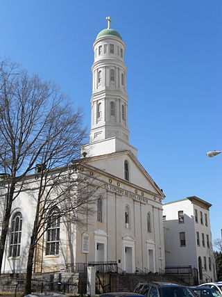
St. Vincent de Paul Church is a historic Roman Catholic church located within the Archdiocese of Baltimore at 120 N. Front Street, Baltimore, Maryland, United States.

Cedarcroft is a distinctive residential neighborhood in the North district of Baltimore, bordered by Gittings, East Lake and Bellona Avenue avenues and York Road. According to Baltimore City's Commission for Historical and Architectural Preservation (CHAP), the houses in Cedarcroft are in the Dutch Colonial Revival, Federal Revival, Tudor Revival, Georgian Revival, Cape Cod Revival, Bungalow, and Italianate styles of architecture.
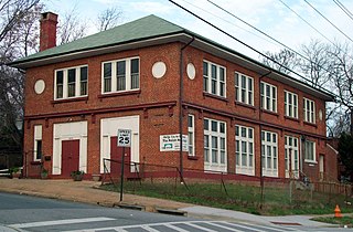
Polish Home Hall is a historic building located in the waterfront industrial/commercial/residential and heavily ethnic community of Curtis Bay in southern Baltimore, Maryland,. Built on the southwest corner of Fairhaven Avenue and Filbert Street near the top of the commanding heights overlooking to the east the sloping streets of the neighborhood of Curtis Bay, about four city blocks wide and 15 blocks length.

Patterson Park is a neighborhood in Baltimore, Maryland, United States. Named for the 137-acre park that abuts its north and east sides, the neighborhood is in the southeast section of Baltimore city, roughly two miles east of Baltimore's downtown district.
Baltimore National Heritage Area is a federally designated National Heritage Area encompassing portions of Baltimore, Maryland, in the United States. The designated area includes the central portion of the city, waterfront, inner neighborhoods and portions of the city's park system. The district includes Fort McHenry and the Inner Harbor, as well as portions of the Charles Street, Falls Road, National Historic Seaport and Star Spangled Banner Maryland Scenic Byways. The Baltimore National Heritage Area was established on March 30, 2009, by the Omnibus Public Land Management Act of 2009. The designation recognizes the area's unique historic and cultural character, and is intended to stimulate economic development, tourism and historic preservation.

East Monument Historic District or Little Bohemia, is a national historic district in Baltimore, Maryland. It is a large residential area with a commercial strip along East Monument Street. It comprises approximately 88 whole and partial blocks. The residential area is composed primarily of rowhouses that were developed, beginning in the 1870s, as housing for Baltimore's growing Bohemian (Czech) immigrant community. During the late 19th and early 20th centuries the neighborhood was the heart of the Bohemian community in Baltimore. The Bohemian National Parish of the Roman Catholic Church, St. Wenceslaus, is located in the neighborhood. The historic district includes all of McElderry Park and Milton-Montford, most of Middle East and Madison-Eastend, and parts of Ellwood Park.
The history of Czechs in Baltimore dates back to the mid-19th century. Thousands of Czechs immigrated to East Baltimore during the late 19th and early 20th centuries, becoming an important component of Baltimore's ethnic and cultural heritage. The Czech community has founded a number of cultural institutions to preserve the city's Czech heritage, including a Roman Catholic church, a heritage association, a gymnastics association, an annual festival, a language school, and a cemetery. During the height of the Czech community in the late 19th century and early 20th century, Baltimore was home to 12,000 to 15,000 people of Czech birth or heritage. The population began to decline during the mid-to-late 20th century, as the community assimilated and aged, while many Czech Americans moved to the suburbs of Baltimore. By the 1980s and early 1990s, the former Czech community in East Baltimore had been almost entirely dispersed, though a few remnants of the city's Czech cultural legacy still remain.
The history of Poles in Baltimore dates back to the late 19th century. The Polish community is largely centered in the neighborhoods of Canton, Fell's Point, Locust Point, and Highlandtown. Poles are the largest Slavic ethnic group in the city and one of the largest European ethnic groups.

Hollins–Roundhouse Historic District is a national historic district in Baltimore, Maryland, United States. It is a primarily residential area characterized by 19th century rowhouses. The neighborhood is historically significant due to its association with the development of rail transportation in Maryland. Additional historical significance comes from the neighborhood's association with ethnic immigration to Baltimore. During the 1840s and 1850s the area was a center of settlement for Baltimore's German and Irish communities, many of whom immigrated to the United States to work in the rail industry. Later, from the 1880s to the 1920s, the neighborhood became established as the center of Baltimore's Lithuanian immigrant community. Because of the large Lithuanian population in the area north of Hollins Street, the area became known as Little Lithuania. A few remnants of the neighborhood's Lithuanian heritage still remain, such as Lithuanian Hall located on Hollins Street.

There have been a variety of ethnic groups in Baltimore, Maryland and its surrounding area for 12,000 years. Prior to European colonization, various Native American nations have lived in the Baltimore area for nearly 3 millennia, with the earliest known Native inhabitants dating to the 10th millennium BCE. Following Baltimore's foundation as a subdivision of the Province of Maryland by British colonial authorities in 1661, the city became home to numerous European settlers and immigrants and their African slaves. Since the first English settlers arrived, substantial immigration from all over Europe, the presence of a deeply rooted community of free black people that was the largest in the pre-Civil War United States, out-migration of African-Americans from the Deep South, out-migration of White Southerners from Appalachia, out-migration of Native Americans from the Southeast such as the Lumbee and the Cherokee, and new waves of more recent immigrants from Latin America, the Caribbean, Asia and Africa have added layers of complexity to the workforce and culture of Baltimore, as well as the religious and ethnic fabric of the city. Baltimore's culture has been described as "the blending of Southern culture and [African-American] migration, Northern industry, and the influx of European immigrants—first mixing at the port and its neighborhoods...Baltimore’s character, it’s uniqueness, the dialect, all of it, is a kind of amalgamation of these very different things coming together—with a little Appalachia thrown in...It’s all threaded through these neighborhoods", according to the American studies academic Mary Rizzo.
The history of Hispanics and Latinos in Baltimore dates back to the mid-20th century. The Hispanic and Latino community of Baltimore is the fastest growing ethnic group in the city. There is a significant Hispanic/Latino presence in many Southeast Baltimore neighborhoods, particularly Highlandtown, Upper Fell's Point, and Greektown. Overall Baltimore has a small but growing Hispanic population, primarily in the Southeast portion of the area from Fells Point to Dundalk.
The Berea–Biddle Street Historic District is a national historic district in Baltimore, Maryland, United States. It is located in the far eastern part of the historic city bounds, and is roughly bounded by the Edison Highway, Federal Street, North Rose Street, and the railroad tracks of the Penn Central Railroad. This area was one of the last to be developed within the city's 1851 boundaries, and consists mainly of two-story rowhouses built between about 1890 and 1925. The centerpiece of the district is the St. Katherine of Sienna Roman Catholic church and school complex.
Madison-Eastend is a neighborhood in the heart of East Baltimore, Maryland. Madison-Eastend occupies 66.7 acres of land north of Patterson Park and south of Amtrak's Northeast Corridor. The neighborhood is bounded by the neighborhoods of Ellwood Park and McElderry Park to the south, Milton-Montford to the west, Biddle Street to the north, and Orangeville to the east. The swath of land between Johns Hopkins Hospital and Frank C Bocek Park, which includes Madison-Eastend, is often referred to as the "Down the Hill" neighborhood by local residents.
The history of White Americans in Baltimore dates back to the 17th century when the first white European colonists came to what is now Maryland and established the Province of Maryland on what was then Native American land. White Americans in Baltimore are Baltimoreans "having origins in any of the original peoples of Europe, the Middle East or North Africa." Majority white for most of its history, Baltimore no longer had a white majority by the 1970s. As of the 2010 census, white Americans are a minority population of Baltimore at 29.6% of the population. White Americans have played a substantial impact on the culture, dialect, ethnic heritage, history, politics, and music of the city. Since the earliest English settlers arrived on the shores of the Chesapeake Bay, Baltimore's white population has been sustained by substantial immigration from all over Europe, particularly Central Europe, Eastern Europe, and Southern Europe, as well as a large out-migration of White Southerners from Appalachia. Numerous white immigrants from Europe and the European diaspora have immigrated to Baltimore from the United Kingdom, Germany, Ireland, Poland, Italy, the Czech Republic, Slovakia, Lithuania, Russia, Ukraine, Spain, France, Canada, and other countries, particularly during the late 19th century and early 20th century. Smaller numbers of white people have immigrated from Latin America, the Caribbean, the Middle East, North Africa, and other non-European regions. Baltimore also has a prominent population of white Jews of European descent, mostly with roots in Central and Eastern Europe. There is a smaller population of white Middle Easterners and white North Africans, most of whom are Arab, Persian, Israeli, or Turkish. The distribution of White Americans in Central and Southeast Baltimore is sometimes called "The White L", while the distribution of African Americans in East and West Baltimore is called "The Black Butterfly."


