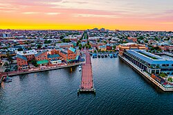
Fell's Point is a historic waterfront neighborhood in southeastern Baltimore, Maryland, established around 1763 along the north shore of the Baltimore Harbor and the Northwest Branch of the Patapsco River. Located 1.5 miles east of Baltimore's downtown central business district, Fells Point is known for its maritime history and character.
The neighborhood has numerous antique, music, and other stores, restaurants, coffee bars, a municipal markethouse with individual stalls, and over 120 pubs.
Across its 250 year history, Fells Point has hosted large large immigrant communities, including Irish, Germans, Jews, Poles, Ukrainians, Russians, Czechs, and Slovaks. Since the 1970s, middle- to upper-middle-income residents have increasingly adopted the area, restoring and preserving historic homes and businesses. Sometimes now called "Spanish Town," Upper Fell's Point to the north along Broadway has gained a sizable Latino community, primarily Mexican and Central American immigrants, mostly since the 1980s
This Fells Point waterfront is an upscale residential area and tourist destination featuring first rate hotels and restaurants. A short walk from the Inner Harbor, the neighborhood can be reached by foot, water taxi barges, bus or car. It is one of several areas in and around Baltimore listed on the National Register of Historic Places, (maintained by the National Park Service), the first designated from Maryland, and is one of the first registered historic districts in the United States to combine two separate waterfront communities (along with Federal Hill to the southwest across the Patapsco River and the Harbor on the "Old South Baltimore" peninsula of "Whetstone Point" at Fort McHenry).[2][3]
History
The waterfront of the Northwest Branch of the Patapsco River, the old Basin, at Fells PointEat Bertha's Mussels tavern and restaurant in Fells Point
First described by a European seafarer as "Long Island Point" in 1670, the area later to be known as Fells Point was a thin little peninsula jutting out southwestward between the streams of Jones Falls and Harford Run (later covered over by Central Avenue) to the west and Harris Creek to the east (now culverted beneath the community of Canton) and further east to Colgate Creek (now surrounded by the Dundalk and Sea Girt Marine Terminals). Later land was patented with the title of "Copus Harbor". Nearby Baltimore Town to the west at the headwater of the Patapsco River's Northwest Branch was land patented under the name of "Cole's Harbor" and "Todd's Range" to William Cole and later sold to Charles and Daniel Carroll. This area was later established as a "port of entry" by the General Assembly of the Province of Maryland in 1706. After several local farmers and plantation owners originally planning to establish a town on the northeastern shores of the Middle Branch of the Patapsco (also known as "Ridgeley's Cove") were stymied by the objections of local owner William Moale, who thought the land was too valuable as a site of iron ore deposits. So the new town site was moved further to the northeast to the head of the Northwest Branch. Established as a town by the authority of the Colonial Assembly on July 30, 1729, (and signed by Governor Benedict Leonard Calvert on August 8), several streets were laid out in the "Original Survey" of January 12, 1730, with the main one going east-to-west called "Long Street" (later by the 1760s as "Market Street", then renamed East and West Baltimore Streets) and several others intersecting from north-to-south such as Forrest (later Charles), Calvert, running north from "The Basin" (today's Inner Harbor) in 1730.
Joined in 1732, to the northeast along the banks of the stream "Jones Falls" (which originates in northern Baltimore County near the Pennsylvania border) by the laying out of several streets on a northwest to southeast angle by David Jones and named "Jones's Town" with streets such as Front, High, and Low. Founded by William Fell, who was attracted by its deep water and proximity to agriculture and thick forests,[citation needed] Fell's Point became a shipbuilding and commercial center. About 1763, William's son Edward Fell laid out streets and began selling plots for homes. The waterfront village port grew quickly, and eventually incorporated with nearby Baltimore Town to the west and Jones Town to the northwest (which had merged in 1745) in 1773 to form a new Town of Baltimore and later beginning in 1796 and taking effect in January 1797, becoming incorporated by the State of Maryland's act of the General Assembly to become the City of Baltimore (under the title of "the Mayor and City Council of Baltimore").
In 1784, the combined town's market house system was expanded from the original first Centre Market (later known as "Marsh Market") on Market Place (between East Pratt Street to the south and Long Street (later called Market Street, then East Baltimore Street) to the north from 1767. Two additional market areas were established shortly after the end of the American Revolutionary War in 1784. Known first as the "Western Precincts Market" and renamed later as the Lexington Market (by future West Lexington and North Eutaw Streets) on land donated by Continental Army Col. John Eager Howard (1752-1827), an influential Baltimore citizen with a large estate named "Belvidere" surrounding the town to the west and north). To the east borders of the town in that same year was the new "Eastern Precincts Market", also later renamed Fells Point Market or Broadway Market which was located for several blocks length between Fleet Street and Thames Street at the harborside. Later the municipal market system extended to include 12 markets spread throughout the center city by the early 20th century. All became focal point and gathering places for their neighborhoods and attracted customers from the entire city and metropolitan area. The area grew wealthy on the tobacco, flour, and coffee trades overseas through the 18th and 19th centuries.[4]
Fell's Point shipyards became best known for producing topsail schooners, sometimes called "Baltimore clippers", renowned for their great speed and handling. They were excellent blockade runners, and were frequently used as armed privateers. The schooner "Pride of Baltimore II" is based on the "Chasseur", built by Thomas Kemp, which was one of the most successful privateers built in Fell's Point during the War of 1812.[5]
During the War of 1812 (1812-1815), Fells Point's yards built and supported dozens of privateers which preyed on British shipping vessels. Between 1810 and 1815, the yards produced over 150 schooners.[6] Consequently, Baltimore became a principal target of the British during the war, which eventually led to the attack on the city and the bombardment of Fort McHenry in September 1814. Because of this, many people have claimed the British referred to Baltimore as a "nest of pirates", citing Hezekiah Niles' "Niles' Weekly Register", the famous nationally circulated newspaper. However, no such reference has ever been found to support that claim.
It has been an immigrant neighborhood since the 19th century, in part because it was a major point of entry into the United States,[7] but mainly because jobs were available in Baltimore's industries and on the waterfront. In the era before mass transportation, immigrants crowded into the cheap housing near the shipbuilding yards, warehouses and factories of Fells Point. This added to the multicultural fabric of the area, but also caused the more affluent to move into other parts of the city.
In 1835, the later famous abolitionist, writer/author, public speaker/orator, agitator and minister/ambassador Frederick Douglass (1818-1895), while still enslaved, was hired out to the shipbuilder John A. Robb as a caulker at the Fells Point shipyard.[8][9] In his autobiography, Douglass recounts that, years earlier, the first time he had been sent to Baltimore, the Fells Point neighborhood was where he taught himself to read and write, copying the letters with which the men in the shipyard labeled boards and "making friends of all the little white boys whom I met in the street. As many of these as I could, I converted into teachers."[10]
Fells Point remained a shipbuilding center until the Civil War, when it could no longer handle the larger ships (also now built with steam power and paddle wheels/screw propellers) then coming into use. Likewise, the shipping industry slowly moved away to larger facilities, some of the newer shipyards further downriver with deeper waters close to shore on the outer Patapsco River, and the Fells Point area became a manufacturing center, with innovations in canning, along with nearby Canton to the east, which was an early commercial/industrial and residential development by the Canton Company of the O'Donnell family and Pattersons in the early 1800s.[11] and packing. The neighborhood escaped serious damage[12] during the Great Baltimore Fire of February 1904, which destroyed the downtown financial area further west. Eventually, much of the manufacturing left the city by the 1980s, resulting in urban decay until preservationists in the 1960s, 1970s and late 20th century organized to save the area's historic buildings and neighborhood waterfront fabric along with Federal Hill on the other western side of the newly renamed with proposed redevelopment of the Inner Harbor (formerly called "The Basin") from a proposed East-West Highway of Interstate 95 which was to run north to south down the East Coast states, begun in the mid-1960s.
In 1965, city, state and some federal transit planners proposed to link Interstate 83 (Jones Falls Expressway going north from downtown since 1962), with Interstate 70 (a cross-country highway stretching west to east - from Baltimore to Sacramento, California, but would be designated here as I-70 West) and Interstate 95, (the main East Coast, Maine to Florida super-highway) by building an elevated highway along the north shore of the Baltimore Harbor and Port. This project would have entailed extensive demolition within Fells Point, and across the river in Federal Hill/South Baltimore and the highway would have cut off the remainder of the neighborhood from the waterfront. An "expressway revolt" against the proposals was raised by local residents and derailed the project. Another proposal had I-83 going under the harbor in an alignment that completely avoided Fells Point, but that was scrapped as well. Fells Point's addition to the National Register of Historic Places (supervised by the National Park Service of the United States Department of the Interior) prevented the use of federal funds for the road project, and contributed to the project's cancellation.[14] One of the leaders of the revolt was social worker Barbara Mikulski, who was later elected a City Council member and later a U.S. Representative followed by as a U.S. Senator from Maryland, one of the first women elected to that upper chamber of the United States Congress and by 2014, one of the longest serving when she retired.
Fells Point, located to the east of the Inner Harbor, suffered extensive flooding during Hurricane Isabel in September 2003,[15] with water as high as 10 feet.[16]
Architecture
Fells Point includes a diversity of historic architecture. Flemish bond brick is used in some of the earliest homes, while row housing is prominent of nineteenth and early twentieth century construction. Gabled roof buildings and Victorian homes are also interspersed with other housing and use types.[17][18]
Historic buildings include:
The Robert Long House, at 812 South Ann Street, built in 1765, is the oldest surviving home in Baltimore.[19]
The Saint Patrick Catholic Church (founded in 1792, current building on Broadway, completed in 1898) one of the first parishes in the Roman Catholic Archdiocese of Baltimore, was unfortunately damaged in the 2011 Virginia earthquake. While the building was condemned and the steeple sustained significant damage, the building reopened for Mass on Ash Wednesday in 2012.[20][21]
Awards
In 2012, Fells Point was selected by the American Planning Association as one of the Great Places in America (neighborhood category),[19] which "celebrates places of exemplary character, quality, and planning".[22]
Fell's Point Fun Festival started in 1966 in response to the proposed I-95 freeway that was to run through the neighborhood. The original purpose of the festival was to raise money to help save Fell's Point and to raise awareness of the historical significance of the neighborhood and its plight. The weekend-long Fun Festival, celebrated in October, has an estimated attendance of over 700,000. The event includes entertainment, arts and crafts vendors, and cultural and culinary offerings.[23]
Fell's Point Privateer Festival is an annual weekend-long festival in April celebrating the privateer and maritime history of Fell's Point. Activities include educational demonstrations, a pub crawl, pet costume contest, and pyrate's ball.[24]
Halloween in Fell's Point occurs annually on October 31 celebrating Halloween. The informal gathering takes place in and around Broadway Square and Thames Street. As the evening goes on, hundreds of individuals come dressed in costume and participate in taking photos, trick-or-treating, and pub crawling.[25]
Fell's Point Olde Tyme Christmas Festival is held during the first weekend in December and includes a traditional Christmas market, pet costume contest, and a Reindeer Run pub crawl.[26]
Demographics
At the census[27] of 2010, 3,168 people resided in the neighborhood, 61% white, 24.9% Hispanic, 7.4% African American, and 6.7% other. 37.0% of occupied housing units were owner-occupied, and 17.4% vacant.
83.7% of the working-age population were employed, 4.0% were unemployed, and 13.1% were not in the labor force.[28] 7.5% of families and 12.6% of the population were below the poverty line. The median household income was US$46,167.
In popular culture
Several films and television shows have been filmed in Fell's Point.
The 1993 film Sleepless in Seattle had several scenes of 'Annie's house' filmed in Fells Point.
Some fictional works make reference to Fell's Point.
The Doctor Who character Peri Brown portrayed by English actress Nicola Bryant is from Fell's Point, according to some novels. This detail was never stated on-screen during the character's original run on the program (1984-1986), though it was confirmed in Tales of the Tardis, a spin off marking the 60th anniversary of the program (2023).[29]
The Inner Harbor is a historic seaport, tourist attraction, and landmark in Baltimore, Maryland. It was described by the Urban Land Institute in 2009 as "the model for post-industrial waterfront redevelopment around the world". The Inner Harbor is located at the mouth of Jones Falls, creating the wide and short northwest branch of the Patapsco River. The district includes any water west of a line drawn between the foot of President Street and the American Visionary Art Museum.
Locust Point is a peninsular neighborhood in Baltimore, Maryland. Located in South Baltimore, the neighborhood is entirely surrounded by the Locust Point Industrial Area; the traditional boundaries are Lawrence street to the west and the Patapsco River to the north, south, and east. It once served as a center of Baltimore's Polish-American, Irish-American and Italian-American communities; in more recent years Locust Point has seen gradual gentrification with the rehabilitation of Tide Point and Silo Point. The neighborhood is also noted as being the home of Fort McHenry and the western end of its namesake tunnel that carries eight lanes of Interstate 95 under the river.
Federal Hill is a neighborhood in Baltimore, Maryland, that lies just to the south of the city's central business district. Many of the structures are included in the Federal Hill Historic District, listed on the National Register of Historic Places in 1970. Other structures are included in the Federal Hill South Historic District, listed in 2003.
Canton is a historic waterfront neighborhood in Baltimore, Maryland, United States. The neighborhood is along Baltimore's outer harbor in the southeastern section of the city, roughly 2 miles (3 km) east of Baltimore's downtown district and next to or near the neighborhoods of Patterson Park, Fell's Point, Highlandtown, and Brewers Hill.
The Pride of Baltimore was a reproduction of a typical early 19th-century "Baltimore clipper" topsail schooner, commissioned to represent Baltimore, Maryland. This was a style of vessel made famous by its success as a privateer commerce raider, a small warship in the War of 1812 (1812–1815) against British merchant shipping and the world-wide British Royal Navy. After the end of the war, Baltimore Clippers did not have sufficient cargo capacity for normal merchant trade, so some were used in the illegal opium trade into China and vessels of the same type were used in the transatlantic slave trade from Africa.
Power Plant Live! is a collection of bars, restaurants and other businesses in the Inner Harbor section of downtown Baltimore, Maryland. It was developed by The Cordish Companies and opened in phases during 2001, 2002, and 2003. The entertainment complex gets its name from the nearby "Power Plant" building, three blocks south on municipal Pier 4 on East Pratt Street facing the Inner Harbor, which was also later re-developed by Cordish.
Curtis Bay is a residential / commercial / industrial neighborhood in the southern portion of the City of Baltimore, Maryland, United States.
Union Square is a neighborhood located in the Sowebo area of Baltimore. It dates to the 1830s and includes a historic district of houses and commerce buildings.
Westport is a neighborhood in south Baltimore, Maryland. Westport is a majority African-American neighborhood that has struggled with crime, housing abandonment, and unemployment in the past decade. The neighborhood is bordered by the Middle Branch of the Patapsco River on the east, the city neighborhoods of Cherry Hill, Brooklyn and the southwestern Baltimore County community of Lansdowne to the southwest, Hollins Ferry Road and the Mount Winans and Lakeland neighborhoods to the west, and Interstate 95 to the north, along with the South Baltimore communities of Federal Hill and Otterbein. The Baltimore–Washington Parkway runs through the middle of Westport and intersects with Interstate 95, the main East Coast super-highway, north to south, Maine to Florida.
St. Paul Street and Calvert Street are a one-way pair of streets in Downtown Baltimore and areas north. The streets, which are part of Maryland Route 2, are two of Baltimore's best-known streets in the downtown area.
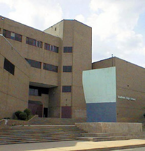
Southern High School was a former public secondary school on Warren Avenue between William Street to the west and Riverside Avenue to the east, in the Federal Hill neighborhood of the northern side of the larger old South Baltimore community on the Whetstone Point peninsula. With historic Fort McHenry from the War of 1812 (1812-1815), to the southeast at the point itself and additional residential areas surrounding the high school in tightly packed rowhouses and streets known as Locust Point and Riverside to the south and southeast along with the restored Otterbein and Sharp-Leadenhall neighborhoods to the west, also just south of the downtown central business district and famed "Inner Harbor" of the City of Baltimore, in Maryland.
Brooklyn is one of the southernmost neighborhoods in Baltimore, Maryland. It is located near Anne Arundel County along Governor Ritchie Highway which is also Maryland Route 2. Its main roads are South Hanover Street,, Potee Street, and East Patapsco Avenue, Sixth Street, Tenth Street, and West Bay Avenue which borders the neighboring Curtis Bay community to the east, running through Bay Brook Park, which separates the two. South Hanover Street also serves as the dividing line between east–west streets in Brooklyn, as Charles Street does not exist here.
Upper Fells Point, also known as "Fells Prospect," is a neighborhood of Baltimore, Maryland, United States. Located north of Fells Point, originally the neighborhood was home to Baltimore's dock workers. By the 1880s canneries and factories provided employment to new immigrants, including Irish, Italians and Poles. In the early 1900s these new Americans were joined by Jews, Lithuanians and Greeks. Today its tidy brick rowhouses and tree-lined streets are home to both old-timers and young urban professionals. It is also the heart of Baltimore's growing Latino community and is sometimes called "Spanish Town". Although most Hispanics in the neighborhood are Mexicans, there are significant populations of Salvadorans, Puerto Ricans, Hondurans, Dominicans, Guatemalans, Colombians, and Cubans, as well as many others.
St. Paul's Protestant Episcopal Church, more commonly called Old St. Paul's Church today, is a historic Episcopal church located at 233 North Charles Street at the southeast corner with East Saratoga Street, in Baltimore, Maryland, near "Cathedral Hill" on the northern edge of the downtown central business district to the south and the Mount Vernon-Belevedere cultural/historic neighborhood to the north. It was founded in 1692 as the parish church for the "Patapsco Parish", one of the "original 30 parishes" of the old Church of England in colonial Maryland.
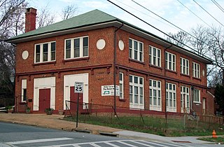
Polish Home Hall is a historic building located in the waterfront industrial/commercial/residential and heavily ethnic community of Curtis Bay in southern Baltimore, Maryland,. Built on the southwest corner of Fairhaven Avenue and Filbert Street near the top of the commanding heights overlooking to the east the sloping streets of the neighborhood of Curtis Bay, about four city blocks wide and 15 blocks length.
Hendler Creamery is a historic industrial complex in Jonestown, Baltimore, Maryland. Since it spans an entire block it has addresses at 1100 E. Baltimore St. and 1107 E. Fayette St. "The Hendler Creamery is historically significant for its contribution to the broad patterns of history in three areas of significance: transportation, performing arts, and industry."
Charles Center is a large-scale urban redevelopment project in central Baltimore's downtown business district of the late 1950s and early 1960s. Beginning in 1954, a group called the "Committee for Downtown" promoted a master plan for arresting the commercial decline of central Baltimore. In 1955, the "Greater Baltimore Committee", headed by banker and developer James W. Rouse, joined the effort. A plan was developed by noted American urban planner and architect David A. Wallace, (1917−2004), strongly supported by Mayors Thomas L. J. D'Alesandro, Jr. (1947−1959) and Theodore R. McKeldin, and many in their administrations, which formed the basis of a $25 million bond issue voted on by the citizens of Baltimore City during the municipal elections in November 1958. The architects' view of the overall Charles Center Redevelopment Plan with the conceptions of possible buildings, lay-out and plan that was publicized to the voters that spring and summer before, only slightly resembles the actual buildings and designs that later were really constructed by the mid-1970s.
"Mount Winans" is a mixed-use residential, commercial and industrial neighborhood in the southwestern area of the City of Baltimore in Maryland. Its north, south and east boundaries are marked by the various lines of track of the CSX Railroad. In addition, Hollins Ferry Road running to the south towards suburban Baltimore County in the southwest and further connecting with adjacent Anne Arundel County to the southeast, draws its western boundary.
Baltimore is the most populous city in the U.S. state of Maryland. With a population of 585,708 at the 2020 census, it is the 30th-most populous city in the United States. Baltimore was designated an independent city by the Constitution of Maryland in 1851, and is currently the most populous independent city in the nation. As of the 2020 census, the population of the Baltimore metropolitan area was estimated to be 2,838,327, making it the 20th-largest metropolitan area in the country. When combined with the larger Washington metropolitan area, the Washington–Baltimore combined statistical area (CSA) has a 2020 U.S. census population of 9,973,383, the third-largest in the country.
Federal Hill Park is a 10.3 acres park located in Baltimore, Maryland on the south shore of the Inner Harbor. The park is a signature Baltimore landmark and offers visitors some of the most noted views in the city often photographed looking north to the downtown skyline of skyscrapers across the Inner Harbor of the Northwest Branch of the Patapsco River / Baltimore Harbor. The Federal Hill surrounding neighborhood to the west and south is named for the prominent hill and is also known as old South Baltimore. The now graded grass lawn hill and park, was originally a jagged cliffs and bluffs of red clay which was mined in the 18th and 19th centuries after being first sighted and described by Captain John Smith of England on his voyages of exploration of the Chesapeake Bay from the first English colony at Jamestown, Virginia in 1608. The noted famous site today is bounded by Francis Scott Key Highway along the waterfront to the north, Battery Avenue to the west, Warren Avenue to the south, and Covington Street to the east. Baltimore city acquired the hill as public property in 1880 after it was used and fortified as a fort with heavy artillery by the Union Army during the American Civil War (1861-1865). It was established then as a city park operated and maintained by the city Department of Recreation and Parks.
This page is based on this Wikipedia article Text is available under the CC BY-SA 4.0 license; additional terms may apply. Images, videos and audio are available under their respective licenses.


