Queen Anne's County, Maryland

Last updated

Queen Anne's County
1Queen Anne's Co. courthouse.jpg
Queen Anne's County Courthouse in Centreville, Maryland
Flag of Queen Anne's County, Maryland.gif
Seal of Queen Anne's County, Maryland.png
Map of Maryland highlighting Queen Anne's County.svg
Location within the U.S. state of Maryland
Maryland in United States.svg
Maryland's location within the U.S.
Coordinates: 39°02′N76°05′W / 39.03°N 76.08°W / 39.03; -76.08
CountryFlag of the United States.svg United States
StateFlag of Maryland.svg  Maryland
Founded1706
Named for Queen Anne
Seat Centreville
Largest community Stevensville
Area
  Total511 sq mi (1,320 km2)
  Land372 sq mi (960 km2)
  Water139 sq mi (360 km2)  27%
Population
 (2020)
  Total49,874
  Density98/sq mi (38/km2)
Time zone UTC−5 (Eastern)
  Summer (DST) UTC−4 (EDT)
Congressional district 1st
Website www.qac.org

Queen Anne's County is located on the Eastern Shore of the U.S. state of Maryland. As of the 2020 census, the population was 49,874. [1] Its county seat and most populous municipality is Centreville. [2] The census-designated place of Stevensville is the county's most populous place with population of 7,442 as of 2020. The county is named for Queen Anne of Great Britain, who reigned when the county was established in 1706 during the colonial period.

Contents

Queen Anne's County is included in the Baltimore-Columbia-Towson, MD Metropolitan Statistical Area, which is also included in the Washington-Baltimore-Arlington, DC-MD-VA-WV-PA Combined Statistical Area, and is the easternmost in both.

Chesapeake Bay Bridge connects Kent Island in Queen Anne's County across Chesapeake Bay to Anne Arundel County. The American Discovery Trail runs through the county.

History

Queen Anne's County has 265 miles of waterfront, much of that being the shores of Kent Island, which stands out from the eastern shore of the Chesapeake Bay. From the waters of this county, watermen have harvested oysters, crabs, and terrapin. Migrating waterfowl overwinter here, and hunting for geese and ducks has been an important part of the county's history. The first Anglo-European settlement in Maryland was on Kent Island on August 21, 1631, and included twenty-five settlers in a manor house, a fort, and other buildings. The settlement was referred to as Winston's Island. The first houses were built similar to log cabins. The county has a number of properties on the National Register of Historic Places, [3] but nothing remains of this original settlement. Stevensville, earlier known as Broad Creek, is one of the oldest towns still existing.

Queen Anne's County was organized under a sheriff in 1706, bounded by Talbot, Kent, and Dorchester counties. In 1713, Queen Anne's County became an English postal district; the sheriff was also appointed as the postmaster and would travel to Annapolis, Maryland by boat across the Chesapeake Bay to obtain mail. In 1773 a part of Queen Anne's County, together with a portion of Dorchester County, was taken to form Caroline County. The county now is enclosed by Talbot, Caroline, and Kent counties, as well as the Chesapeake Bay.

By the time of Independence, the county had several churches, a government, school, and a postal system. It was developed for agriculture, and enslaved African Americans worked the fields of plantations. Tobacco was an early commodity crop but it exhausted the soil. By the Revolution, some planters were converting to mixed agriculture, which was less labor-intensive. They sold excess slaves in the domestic trade to the developing cotton plantations of the Deep South.

In 1876, Queen Anne's County had the first printed independent paper called the Maryland Citizen. A bank was located in Centreville; the Centreville National Bank is still operating. A railway was constructed here in 1868; it operated from Baltimore, passing around the top of the Chesapeake Bay down to Queenstown, and connected with other railroads that continued east into [4] Delaware as far as Rehoboth, and southward to the Eastern Shore of Virginia.

In the 20th century, Queen Anne's County was the home of Jimmie Foxx, who was elected to the Baseball Hall of Fame. A statue and small park commemorate him in Sudlersville, where Foxx grew up.

Politics and government

Queen Anne's was historically the most strongly secessionist county in Maryland, dominated by the Democratic Party of the planters. Following the American Civil War, the predominately conservative white voters voted for the Democratic presidential nominee in every election from 1868 to 1948, though Herbert Hoover came within a point of defeating Al Smith in 1928 amidst great Southern resentment to Smith's Catholicism and opposition to Prohibition. [5] Former general Dwight D. Eisenhower became the first Republican to carry the county in 1952.

Since the late 20th century, Queen Anne's white voters have largely shifted to the Republican Party, in a realignment that has taken place among conservative whites across the South following the tumultuous 1960s and passage of national civil rights legislation. No Democratic presidential candidate has carried Queen Anne's County since Texan Lyndon Johnson’s 1964 landslide. [6] Democrat Jimmy Carter in 1980 remains the last Democrat to obtain even forty percent of the county’s vote, and he in 1976 was the last to come within ten points of winning the county.

Voter registration and party enrollment as of March 2024 [7]
Republican 20,046
Democratic 11,031
Unaffiliated8,867
Libertarian 233
Other parties 393
Total40,570
United States presidential election results for Queen Anne's County, Maryland [8]
Year Republican  /  Whig Democratic Third party
No.%No.%No.%
2020 18,74161.87%10,70935.35%8402.77%
2016 16,99364.07%7,97330.06%1,5575.87%
2012 15,82363.58%8,55634.38%5092.05%
2008 15,08762.74%8,57535.66%3831.59%
2004 14,48966.48%7,07032.44%2351.08%
2000 9,97059.48%6,25737.33%5343.19%
1996 7,14752.40%5,05437.06%1,43810.54%
1992 6,82947.05%4,66832.16%3,01720.79%
1988 7,80366.68%3,85732.96%430.37%
1984 6,78469.49%2,93830.09%410.42%
1980 4,74952.12%3,82041.92%5435.96%
1976 3,47950.16%3,45749.84%00.00%
1972 4,38070.45%1,71227.54%1252.01%
1968 2,88846.92%1,96931.99%1,29821.09%
1964 1,95532.55%4,05267.45%00.00%
1960 2,90648.18%3,12651.82%00.00%
1956 3,32155.70%2,64144.30%00.00%
1952 3,17050.60%3,05848.81%370.59%
1948 2,03842.98%2,66056.09%440.93%
1944 2,11941.18%3,02758.82%00.00%
1940 2,50840.94%3,58158.46%370.60%
1936 1,94635.36%3,54864.47%90.16%
1932 1,58329.90%3,68369.57%280.53%
1928 2,66649.47%2,70050.10%230.43%
1924 1,65633.74%3,15564.28%971.98%
1920 2,15737.43%3,51961.07%861.49%
1916 1,24235.50%2,20663.05%511.46%
1912 1,31138.27%1,90255.52%2136.22%
1908 1,13534.04%2,08662.57%1133.39%
1904 1,48738.28%2,25858.12%1403.60%
1900 1,87341.27%2,54456.06%1212.67%
1896 1,91741.53%2,51654.51%1833.96%
1892 1,57939.25%2,28156.70%1634.05%
1888 1,73843.19%2,28656.81%00.00%
1884 1,71042.18%2,34457.82%00.00%
1880 1,66641.93%2,30758.07%00.00%
1876 1,47640.72%2,14959.28%00.00%
1872 1,65447.83%1,80452.17%00.00%
1868 27515.05%1,55284.95%00.00%
1864 38420.58%1,48279.42%00.00%
1860 00.00%874.64%1,78795.36%
1856 00.00%74145.05%90454.95%
1852 72349.59%73550.41%00.00%
1848 72554.23%61245.77%00.00%
1844 74950.92%72249.08%00.00%
1840 77854.07%66145.93%00.00%
1836 63755.20%51744.80%00.00%

Queen Anne's County was granted home rule in 1990 under a state code.

The county has a commission form of government. The commission consists of five commissioners: one at-large and four of whom must reside in the district they represent. All of the commissioners are elected by the general population. The at-large commissioner serves as president the first year following election. County code allows for rotation of the president position thereafter.

The current Board of Commissioners was elected in the 2018 election, and serves a four-year term. The current County Commissioners are Stephen Wilson (District 2), Christopher M. Corchiarino (District 4), Philip L. Dumenil (District 3), James J. Moran (at-large), and Jack N. Wilson, Jr. (District 1). [9] The current form of five commissioners elected at large started in 2002. Prior to the 2002 election, Queen Anne's County was run by three commissioners.

Geography

According to the U.S. Census Bureau, the county has a total area of 511 square miles (1,320 km2), of which 372 square miles (960 km2) is land and 139 square miles (360 km2) (27%) is water. [10]

Adjacent counties

US 50 and US 301 in Queen Anne's County 2022-06-29 09 48 23 View west along U.S. Route 50 and south along U.S. Route 301 (Blue Star Memorial Highway) from the overpass for Nesbit Road in Grasonville, Queen Anne's County, Maryland.jpg
US 50 and US 301 in Queen Anne's County

Major roads and highways

Demographics

Historical population
CensusPop.Note
1790 15,463
1800 14,857−3.9%
1810 16,64812.1%
1820 14,952−10.2%
1830 14,397−3.7%
1840 12,633−12.3%
1850 14,48414.7%
1860 15,96110.2%
1870 16,1711.3%
1880 19,25719.1%
1890 18,461−4.1%
1900 18,364−0.5%
1910 16,839−8.3%
1920 16,001−5.0%
1930 14,571−8.9%
1940 14,476−0.7%
1950 14,5790.7%
1960 16,56913.6%
1970 18,42211.2%
1980 25,50838.5%
1990 33,95333.1%
2000 40,56319.5%
2010 47,79817.8%
2020 49,8744.3%
2023 (est.)52,508 [11] 5.3%
U.S. Decennial Census [12]
1790-1960 [13] 1900-1990 [14]
1990-2000 [15] 2010–2018 [1]

2000 census

As of the census [16] of 2000, there were 40,563 people, 15,315 households, and 11,547 families living in the county. The population density was 109 people per square mile (42 people/km2). There were 16,674 housing units at an average density of 45 per square mile (17/km2). The racial makeup of the county was 89.05% White, 8.78% Black or African American, 0.22% Native American, 0.57% Asian, 0.02% Pacific Islander, 0.43% from other races, and 0.93% from two or more races. 1.09% of the population were Hispanic or Latino of any race. 16.9% were of German, 15.1% American, 14.6% English, 14.2% Irish and 5.3% Italian ancestry.

There were 15,315 households, out of which 33.30% had children under the age of 18 living with them, 62.20% were married couples living together, 9.50% had a female householder with no husband present, and 24.60% were non-families. 19.60% of all households were made up of individuals, and 7.90% had someone living alone who was 65 years of age or older. The average household size was 2.62 and the average family size was 2.99.

In the county, the population was spread out, with 25.40% under the age of 18, 5.80% from 18 to 24, 30.10% from 25 to 44, 25.90% from 45 to 64, and 12.90% who were 65 years of age or older. The median age was 39 years. For every 100 females, there were 99.20 males. For every 100 females age 18 and over, there were 96.80 males.

The median income for a household in the county was $57,037, and the median income for a family was $63,713. Males had a median income of $44,644 versus $30,144 for females. The per capita income for the county was $26,364. About 4.40% of families and 6.30% of the population were below the poverty line, including 7.20% of those under age 18 and 7.30% of those age 65 or over.

2010 census

As of the 2010 United States Census, there were 47,798 people, 18,016 households, and 13,314 families living in the county. [17] The population density was 128.5 inhabitants per square mile (49.6/km2). There were 20,140 housing units at an average density of 54.2 per square mile (20.9/km2). [18] The racial makeup of the county was 88.7% white, 6.9% black or African American, 1.0% Asian, 0.3% American Indian, 1.4% from other races, and 1.7% from two or more races. Those of Hispanic or Latino origin made up 3.0% of the population. [17] In terms of ancestry, 25.9% were German, 22.4% were Irish, 15.8% were English, 6.2% were Italian, and 6.1% were American. [19]

Of the 18,016 households, 34.4% had children under the age of 18 living with them, 60.3% were married couples living together, 9.2% had a female householder with no husband present, 26.1% were non-families, and 20.6% of all households were made up of individuals. The average household size was 2.63 and the average family size was 3.04. The median age was 42.6 years. [17]

The median income for a household in the county was $81,096 and the median income for a family was $89,188. Males had a median income of $57,218 versus $43,371 for females. The per capita income for the county was $35,964. About 3.8% of families and 5.5% of the population were below the poverty line, including 7.0% of those under age 18 and 6.1% of those age 65 or over. [20]

Education

Public schools

  • Kent Island High School
  • Queen Anne's County High School
  • Centreville Middle School
  • Matapeake Middle School
  • Stevensville Middle School
  • Sudlersville Middle School
  • Bayside Elementary School
  • Centreville Elementary School
  • Church Hill Elementary School
  • Grasonville Elementary School
  • Kennard Elementary School
  • Kent Island Elementary School
  • Matapeake Elementary School
  • Sudlersville Elementary School
  • Gunston Day School
  • Wye River Upper School

Colleges and universities

Communities

Towns

Census-designated places

The Census Bureau recognizes the following census-designated places in the county:

Unincorporated communities

See also

Related Research Articles

<span class="mw-page-title-main">Calvert County, Maryland</span> County in Maryland, United States

Calvert County is a county located in the U.S. state of Maryland. As of the 2020 census, the population was 92,783. Its county seat is Prince Frederick. The county's name is derived from the family name of the Barons of Baltimore, the proprietors of the English Colony of Maryland. Calvert County is included in the Washington–Arlington–Alexandria, DC–VA–MD–WV Metropolitan Statistical Area. It occupies the Calvert Peninsula, which is bordered on the east by Chesapeake Bay and on the west by the Patuxent River. Calvert County is part of the Southern Maryland region. The county has one of the highest median household incomes in the United States. It is one of the older counties in Maryland, after St. Mary's, Kent County and Anne Arundel counties.

<span class="mw-page-title-main">Caroline County, Maryland</span> County in Maryland, United States

Caroline County is a rural county located in the U.S. state of Maryland on its Eastern Shore. As of the 2020 census, the population was 33,293. Its county seat is Denton.

<span class="mw-page-title-main">Dorchester County, Maryland</span> County in Maryland, United States

Dorchester County is a county located in the U.S. state of Maryland. At the 2020 census, the population was 32,531. Its county seat is Cambridge. The county was formed in 1669 and named for the Earl of Dorset, a family friend of the Calverts.

<span class="mw-page-title-main">Kent County, Maryland</span> County in Maryland, United States

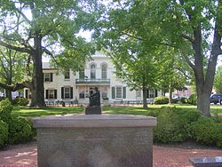
Kent County is a county located in the U.S. state of Maryland. As of the 2020 census, its population was 19,198, making it the least populous county in Maryland. Its county seat is Chestertown. The county was named for the county of Kent in England.

<span class="mw-page-title-main">Talbot County, Maryland</span> County in Maryland, United States

Talbot County is located in the heart of the Eastern Shore of Maryland in the U.S. state of Maryland. As of the 2020 census, the population was 37,526. Its county seat is Easton. The county was named for Lady Grace Talbot, the wife of Sir Robert Talbot, an Anglo-Irish statesman, and the sister of Lord Baltimore.

<span class="mw-page-title-main">Lake Shore, Maryland</span> Census-designated place in Maryland, United States

Lake Shore is a census-designated place and unincorporated community in Anne Arundel County, Maryland, United States, located east of Pasadena. The population of Lake Shore was 19,477 at the 2010 census.

<span class="mw-page-title-main">Parole, Maryland</span> Census-designated place in Maryland, United States

Parole, a suburb of Annapolis, is a census-designated place (CDP) in Anne Arundel County, Maryland, United States. The population was 15,922 at the 2010 census. It has several major roads intersect at the western edge of the state capital, Annapolis, and it contains the Annapolis Mall, a number of other large shopping centers, and the Anne Arundel Medical Center. It is generally considered to be part of Annapolis, rather than a separate town. The neighborhood was named because it was a parole camp, where Union and Confederate prisoners of war were brought for mutual exchange and eventual return to their respective homes.

<span class="mw-page-title-main">Pasadena, Maryland</span> Census-designated place in Maryland, United States

Pasadena is a census-designated place (CDP) in Anne Arundel County, Maryland, United States. The population was 24,287 at the 2010 census.

<span class="mw-page-title-main">Owings, Maryland</span> Census-designated place in Maryland, United States

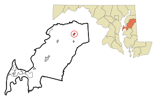
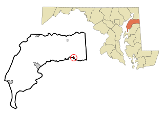
Owings is a town center and census-designated place (CDP) in northern Calvert County, Maryland, United States. The population was 2,149 at the 2010 census, up from 1,325 in 2000.

<span class="mw-page-title-main">Betterton, Maryland</span> Historic district in Maryland, United States

Betterton is a town in Kent County, Maryland, United States. The population was 345 at the 2010 census.

<span class="mw-page-title-main">Galena, Maryland</span> Town in Maryland, United States

Galena is a town in Kent County, Maryland, United States. The population was 612 at the 2010 census.

<span class="mw-page-title-main">Rock Hall, Maryland</span> Town in Maryland, United States

Rock Hall, is a waterfront town located directly on the National Chesapeake Scenic Byway in Kent County, Maryland, United States. The population was 1,310 at the 2010 census.

<span class="mw-page-title-main">Barnesville, Maryland</span> Town in Maryland, United States

Barnesville is a town in Montgomery County, Maryland, United States. It was incorporated in 1888. The population was 144 at the 2020 census.

<span class="mw-page-title-main">Centreville, Maryland</span> Incorporated town in Queen Annes County, Maryland, United States

Centreville is an incorporated town in Queen Anne's County, Maryland, United States on the Delmarva Peninsula. Incorporated in 1794, it is the county seat of Queen Anne's County. The population was 4,285 at the 2010 census. The ZIP code is 21617 and the area codes are 410 and 443. The primary local telephone exchange is 758. It hosts the Queen Anne's County Fair each summer and was home to three franchises during the existence of the Eastern Shore Baseball League—the Colts, Red Sox, and Orioles.

<span class="mw-page-title-main">Stevensville, Maryland</span> CDP in Maryland, United States

Stevensville is a census-designated place (CDP) in Queen Anne's County, Maryland, United States, and is the county's most populous place among both CDPs and municipalities. The community is the eastern terminus of the Chesapeake Bay Bridge. The Stevensville Historic District is one of two registered historic districts in the county, the other being the Centreville Historic District.

<span class="mw-page-title-main">Sudlersville, Maryland</span> Town in Maryland, United States

Sudlersville is a town in the far northeastern corner of Queen Anne's County, Maryland, United States. The ZIP code is 21668 and the area code is 410. The population was 497 at the 2010 census. It is perhaps best known as the hometown of Baseball Hall Of Fame slugger Jimmie Foxx. Other famous residents include astronomer and mathematician Simon Newcomb.

<span class="mw-page-title-main">Millington, Maryland</span> Town in Maryland, United States

Millington is a town in Kent and Queen Anne's counties in the U.S. state of Maryland. The population was 642 at the 2010 census. Millington is the head of navigation for the Chester River.

<span class="mw-page-title-main">Kent Island (Maryland)</span> Largest Island and historic place in the Chesapeake Bay, United States

Kent Island is the largest island in the Chesapeake Bay and a historic place in Maryland. To the east, a narrow channel known as the Kent Narrows barely separates the island from the Delmarva Peninsula, and on the other side, the island is separated from Sandy Point, an area near Annapolis, by roughly four miles (6.4 km) of water. At only four miles wide, the main waterway of the bay is at its narrowest at this point and is spanned here by the Chesapeake Bay Bridge. The Chester River runs to the north of the island and empties into the Chesapeake Bay at Kent Island's Love Point. To the south of the island lies Eastern Bay. The United States Census Bureau reports that the island has 31.62 square miles (81.90 km2) of land area.

Matapeake is an unincorporated community located south of Stevensville on Kent Island, Maryland, United States.

Queen Anne's County Public Schools is a school district on the Eastern Shore of Maryland. All schools are accredited by the Middle States Association of Colleges and Schools.

References

  1. 1 2 "State & County QuickFacts". United States Census Bureau. Archived from the original on September 5, 2015. Retrieved August 24, 2013.
  2. "Find a County". National Association of Counties. Archived from the original on May 31, 2011. Retrieved June 7, 2011.
  3. "National Register Information System". National Register of Historic Places . National Park Service. April 15, 2008.
  4. Clark, Charles B. (1950). The Eastern Shore of Maryland and Virginia. New York: Lewis Historical Publishing Co., Inc. pp. 1053–1070.
  5. Levine, Mark V.; ‘Standing Political Decisions and Critical Realignment: The Pattern of Maryland Politics, 1872-1948’; The Journal of Politics , volume 38, no. 2 (May 1976), pp. 292-325
  6. Sullivan, Robert David; ‘How the Red and Blue Map Evolved Over the Past Century’; America Magazine in The National Catholic Review; June 29, 2016
  7. "Maryland Board of Elections Voter Registration Activity Report March 2024" (PDF). Maryland Board of Elections. Retrieved April 9, 2024.
  8. Leip, David. "Dave Leip's Atlas of U.S. Presidential Elections". uselectionatlas.org. Retrieved June 12, 2018.
  9. "Board of County Commissioners | Queen Anne's County, MD - Official Website". www.qac.org. Retrieved May 30, 2021.
  10. "2010 Census Gazetteer Files". United States Census Bureau. August 22, 2012. Archived from the original on September 13, 2014. Retrieved September 14, 2014.
  11. "Annual Estimates of the Resident Population for Counties: April 1, 2020 to July 1, 2023". United States Census Bureau. Retrieved April 3, 2024.
  12. "U.S. Decennial Census". United States Census Bureau. Retrieved September 14, 2014.
  13. "Historical Census Browser". University of Virginia Library. Retrieved September 14, 2014.
  14. "Population of Counties by Decennial Census: 1900 to 1990". United States Census Bureau. Retrieved September 14, 2014.
  15. "Census 2000 PHC-T-4. Ranking Tables for Counties: 1990 and 2000" (PDF). United States Census Bureau. Retrieved September 14, 2014.
  16. "U.S. Census website". United States Census Bureau . Retrieved January 31, 2008.
  17. 1 2 3 "DP-1 Profile of General Population and Housing Characteristics: 2010 Demographic Profile Data". United States Census Bureau. Archived from the original on February 13, 2020. Retrieved January 22, 2016.
  18. "Population, Housing Units, Area, and Density: 2010 - County". United States Census Bureau. Archived from the original on February 13, 2020. Retrieved January 22, 2016.
  19. "DP02 SELECTED SOCIAL CHARACTERISTICS IN THE UNITED STATES – 2006-2010 American Community Survey 5-Year Estimates". United States Census Bureau. Archived from the original on February 13, 2020. Retrieved January 22, 2016.
  20. "DP03 SELECTED ECONOMIC CHARACTERISTICS – 2006-2010 American Community Survey 5-Year Estimates". United States Census Bureau. Archived from the original on February 13, 2020. Retrieved January 22, 2016.

39°02′N76°05′W / 39.03°N 76.08°W / 39.03; -76.08